
| FIREBAUGH FIREBAUGH CA |
| |
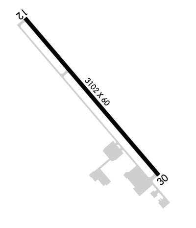
| Lat: N 3651.6 Long: W 12027.9 Elev: 157 Var: -16 Longest Runway: 3102 | ||
| CTAF: 122.9 | ||
| ||||||||||||||||||||||||||||||||
| ||||||||||||||||||||||||||||||||
| Rwy | Rwy | |||||||
| 3102x60 | 3102' | 3102x60 | 3102' | |||||
| Runway ID | Single Wheel | Double Wheel | Double Tandem Wheel | Dual Double Wheel |
| 12/30 | 12,000 | N/A | N/A | N/A |
| These numbers are Advisory and are not limits. The Airport Manager should have more accurate Weight Limits | ||||
 Airport Diagram might not be current. | |
| Facility Name: | FIREBAUGH |
| City Name: | FIREBAUGH |
| County: | FRESNO |
| State abbrev: | CA |
| State Name: | CALIFORNIA |
| Ownership: | PUBLICLY OWNED |
| Use: | OPEN TO THE PUBLIC |
| Owner's Name: | CITY OF FIREBAUGH |
| Address: | 1133 P STREET |
| FIREBAUGH, CA 93622 | |
| Owner's Phone: | 559-659-2043 |
| Manager's Name: | BEN GALLEGOS; CITY MGR. MAINTENANCE CONTACT PUBLIC WORKS, BEN GALLEGOS 559-659-2043 |
| Address: | 1133 P STREET |
| FIREBAUGH, CA 93622 | |
| Phone: | 559-659-2043 |
| FAA Region: | WESTERN-PACIFIC |
| FAA Field Office: | SFO |
| Date | Sunrise | Sunset |
|---|---|---|
| 09/24/21 Friday | 6:51 | 18:56 |
| 09/25/21 Saturday | 6:52 | 18:54 |
| 09/26/21 Sunday | 6:53 | 18:53 |
| 09/27/21 Monday | 6:54 | 18:51 |
| 09/28/21 Tuesday | 6:55 | 18:50 |
| 09/29/21 Wednesday | 6:55 | 18:48 |
| 09/30/21 Thursday | 6:56 | 18:47 |
| 10/01/21 Friday | 6:57 | 18:45 |
| 10/02/21 Saturday | 6:58 | 18:44 |
| 10/03/21 Sunday | 6:59 | 18:42 |
| 10/04/21 Monday | 7:00 | 18:41 |
| 10/05/21 Tuesday | 7:00 | 18:40 |
| 10/06/21 Wednesday | 7:01 | 18:38 |
| 10/07/21 Thursday | 7:02 | 18:37 |
| Airport Attendance Schedule | UNATTENDED |
| Airport Status | OPERATIONAL (This Status can change at any time - please check NOTAMS) |
| Airport Lighting Schedule | ACTVT MIRL RY 12/30 AND VASI RY 30 - CTAF. |
| Airport Storage Available | Tie Downs |
| Extra Services Available | Crop Dusting |
| Wind Indicator | YES - (lighted) |
| Control Tower | NO |
| CTAF Frequency | 122.900 |
| Unicom Frequency | |
| Rotating Beacon Color | CLEAR-GREEN (Light Land Airport) |
| Segmented Circle | YES |
| Landing Fee | NO |
| Airport Inspected | STATE - performed by STATE AERONAUTICAL PERSONNEL |
| Inspection Date | 02/24/2020 |
| Type of Fuel Available | None |
| Airframe Repair Service | NONE |
| Power Plant Repair Service | NONE |
| Latitude | N3651.6 |
| Longitude | W12027.9 (ESTIMATED) |
| Arpt Elevation | 157ft (SURVEYED) |
| Magnetic Variation | 16E |
| 1 miles W | of FIREBAUGH |
| Traffic Pattern Altitude | 850 |
| Sectional Chart | SAN FRANCISCO |
| Operations (Reported) | Yearly | Avg. Daily |
|---|---|---|
| General Aviation Transient | 4000 | 11 |
| General Aviation Local | 6000 | 16 |
| Air Taxi | 0 | 0 |
| Commerical | 0 | 0 |
| Commuter | 0 | 0 |
| Military | 0 | 0 |
| Aircraft based on Field | |
|---|---|
| General Aviation Singles | 8 |
| General Aviation Multi | 1 |
| Jet Aircraft | 0 |
| General Aviation Helicopters | 0 |
| Military Aircraft | 0 |
| Gliders | 0 |
| Ultralights | 0 |
| FSS on field | NO |
| FSS tie-in | RANCHO MURIETA |
| FSS Phone | 1-800-WX-BRIEF |
| Who issues Notams | RIU |
| Notam D service at airport | YES |
| ARTCC Name | OAKLAND |
| Airport Certification | |
| Aircraft Rescue & Firefighting Index | None |
| Airport of Entry | No |
| Custom Landing Rights | No |
| Joint Civil/Military | No |
| Military Landing rights | No |
| NATIONAL PLAN OF INTEGRATED AIRPORT SYSTEMS (NPIAS) |
| FOR CD CTC NORCAL APCH AT 916-361-6874. |
| RWY SAFETY AREA 140 FT BYD RWY 30 END. |
Airport Communications & Frequencies:
| |||||||||||||||
| Runway: 12 | Runway: 30 | ||
| Mag heading: | 124° | Mag heading: | 304° |
| Rwy Slope: | .00% Up | Rwy Slope: | .00% Down |
| Approach: | Approach: | ||
| Pattern: | Right Traffic | Pattern: | Left Traffic |
| Markings: | BASIC | Markings: | BASIC |
| Marking Condition: | FAIR | Marking Condition: | FAIR |
| Arresting Dev: | Arresting Dev: | ||
| Lat & Long: | N3651.8 W12028.1 | Lat. & Long.: | N3651.4 W12027.7 |
| Elev: | 156.9 ft. MSL | Elev: | 157.0 ft. MSL |
| TCH: | TCH: | 29 ft. AGL | |
| Visual Glide Path: | Visual Glide Path: | 3.00 degrees | |
| Displaced Threshold: | No | Displaced Threshold: | No |
| Touchdown Zone: | YES | Touchdown Zone: | YES |
| Touchdown Elev.: | 157.1 feet | Touchdown Elev.: | 157.2 feet |
| Visual Glide Slope: | Visual Glide Slope: | 2-Box VASI on LEFT side of Runway | |
| RVR Equipment: | RVR Equipment: | ||
| RVV Equipment: | NO | RVV Equipment: | NO |
| Approach Lights: | Approach Lights: | ||
| REIL: | NO | REIL: | NO |
| Centerline Lights: | NO | Centerline Lights: | NO |
| Touchdown lights: | NO | Touchdown lights: | NO |
| Runway Category: | Runway with a Visual Approach | Runway Category: | Runway with a Visual Approach |
| Declared Distances: | Declared Distances: | ||
| Obstructions: | ROAD | Obstructions: | ROAD |
| Marked: | NOT Marked/Lighted | Marked: | NOT Marked/Lighted |
| Clearance slope: | 20:1 | Clearance slope: | 33:1 |
| Obstruction height: | 10 feet AGL | Obstruction height: | 15 feet AGL |
| Dist. from runway: | 400 feet | Dist. from runway: | 700 feet |
| Centerline offset: | Centerline offset: | ||
| Comments: | RWY 12 +2' BERM, 6' FENCE & 5' DITCH 80'-140' FM RWY END 125'L TO 125'R. | Comments: |
Thanks for using FltPlan.com
all rights reserved © 1999-2021 by Flight Plan LLC
