
| LAKE TEXOMA (CLOSED) KINGSTON OK |
| |
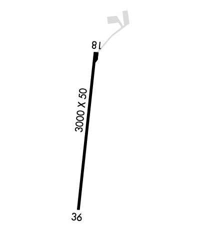
| Lat: N 3359.5 Long: W 09638.6 Elev: 693 Var: -06 Longest Runway: 3000 | ||
| CTAF: 122.8 | ||
| ||
| Rwy | Rwy | |||||||
| 3000x50 | 3000' | 3000x50 | 3000' | |||||
| Runway ID | Single Wheel | Double Wheel | Double Tandem Wheel | Dual Double Wheel |
| 18/36 | 4,000 | N/A | N/A | N/A |
| These numbers are Advisory and are not limits. The Airport Manager should have more accurate Weight Limits | ||||
| FltPlan does not have IFR approach charts available for KF31. |
 Airport Diagram might not be current. | |
| Facility Name: | LAKE TEXOMA STATE PARK |
| City Name: | KINGSTON |
| County: | MARSHALL |
| State abbrev: | OK |
| State Name: | OKLAHOMA |
| Ownership: | PUBLICLY OWNED |
| Use: | OPEN TO THE PUBLIC |
| Owner's Name: | CORP OF ENGINEERS |
| Address: | OK DEP OF TOURISM & REC, LESSEE, PO BOX 52002 |
| OKLAHOMA CITY, OK 73105 | |
| Owner's Phone: | (580) 564-2566 |
| Manager's Name: | KEVIN NUNNELEE |
| Address: | 11500 PARK OFFICE RD, 1988 STATE PARK RD. |
| KINGSTON, OK 73439 | |
| Phone: | 580-564-2566; AFT HR - 580-564-5515. |
| FAA Region: | SOUTHWEST |
| FAA Field Office: | AOK |
| Date | Sunrise | Sunset |
|---|---|---|
| 02/10/26 Tuesday | 7:16 | 18:06 |
| 02/11/26 Wednesday | 7:15 | 18:07 |
| 02/12/26 Thursday | 7:15 | 18:08 |
| 02/13/26 Friday | 7:14 | 18:09 |
| 02/14/26 Saturday | 7:13 | 18:10 |
| 02/15/26 Sunday | 7:12 | 18:11 |
| 02/16/26 Monday | 7:11 | 18:11 |
| 02/17/26 Tuesday | 7:09 | 18:12 |
| 02/18/26 Wednesday | 7:08 | 18:13 |
| 02/19/26 Thursday | 7:07 | 18:14 |
| 02/20/26 Friday | 7:06 | 18:15 |
| 02/21/26 Saturday | 7:05 | 18:16 |
| 02/22/26 Sunday | 7:04 | 18:17 |
| 02/23/26 Monday | 7:03 | 18:18 |
| Airport Attendance Schedule | UNATTENDED |
| Airport Status | OPERATIONAL (This Status can change at any time - please check NOTAMS) |
| Airport Lighting Schedule | ACTVT MIRL RWY 18/36 - CTAF. MIRL RWY 18/36 PRESET LOW INTST; INCR INTST - CTAF. |
| Airport Storage Available | Tie Downs |
| Extra Services Available | NONE |
| Wind Indicator | YES - (lighted) |
| Control Tower | NO |
| CTAF Frequency | 122.800 |
| Unicom Frequency | 122.800 |
| Rotating Beacon Color | WG; ROTG BCN OTS INDEFLY. |
| Segmented Circle | NO |
| Landing Fee | NO |
| Airport Inspected | STATE - performed by STATE AERONAUTICAL PERSONNEL |
| Inspection Date | 02/29/2024 |
| Type of Fuel Available | None |
| Airframe Repair Service | None |
| Power Plant Repair Service | None |
| Latitude | N3359.5 |
| Longitude | W09638.6 (ESTIMATED) |
| Arpt Elevation | 693ft (ESTIMATED) |
| Magnetic Variation | 06E |
| 4 miles E | of KINGSTON |
| Traffic Pattern Altitude | |
| Sectional Chart | DALLAS-FT WORTH |
| Operations (Reported) | Yearly | Avg. Daily |
|---|---|---|
| General Aviation Transient | 0 | 0 |
| General Aviation Local | 0 | 0 |
| Air Taxi | 0 | 0 |
| Commerical | 0 | 0 |
| Commuter | 0 | 0 |
| Military | 0 | 0 |
| Aircraft based on Field | |
|---|---|
| General Aviation Singles | 0 |
| General Aviation Multi | 0 |
| Jet Aircraft | 0 |
| General Aviation Helicopters | 0 |
| Military Aircraft | 0 |
| Gliders | 0 |
| Ultralights | 0 |
| FSS on field | NO |
| FSS tie-in | MC ALESTER |
| FSS Phone | 1-800-WX-BRIEF |
| Who issues Notams | MLC |
| Notam D service at airport | YES |
| ARTCC Name | FORT WORTH |
| Airport Certification | |
| Aircraft Rescue & Firefighting Index | None |
| Airport of Entry | No |
| Custom Landing Rights | No |
| Joint Civil/Military | No |
| Military Landing rights | YES |
| ASSURANCES PURSUANT TO TITLE VI, CIVIL RIGHTS ACT OF 1964 |
| GRANT AGREEMENT HAS EXPIRED; HOWEVER, AGREEMENT REMAINS IN EFFECT FOR THIS FACILITY AS LONG AS IT IS PUBLIC USE. |
| DEER & GEESE ON & INVOF RWY. |
| FOR CD CTC FORT WORTH ARTCC AT 817-858-7584. |
| Runway: 18 | Runway: 36 | ||
| Mag heading: | 180° | Mag heading: | 0° |
| Approach: | Approach: | ||
| Pattern: | Left Traffic | Pattern: | Left Traffic |
| Markings: | BASIC | Markings: | BASIC |
| Marking Condition: | FAIR | Marking Condition: | FAIR |
| Arresting Dev: | Arresting Dev: | ||
| Lat & Long: | N3359.7 W09638.5 | Lat. & Long.: | N3359.2 W09638.6 |
| Elev: | N/A | Elev: | N/A |
| TCH: | TCH: | ||
| Visual Glide Path: | Visual Glide Path: | ||
| Displaced Threshold: | No | Displaced Threshold: | No |
| Touchdown Zone: | NO | Touchdown Zone: | NO |
| Touchdown Elev.: | Touchdown Elev.: | ||
| Visual Glide Slope: | Visual Glide Slope: | ||
| RVR Equipment: | RVR Equipment: | ||
| RVV Equipment: | NO | RVV Equipment: | NO |
| Approach Lights: | Approach Lights: | ||
| REIL: | NO | REIL: | NO |
| Centerline Lights: | NO | Centerline Lights: | NO |
| Touchdown lights: | NO | Touchdown lights: | NO |
| Runway Category: | Runway with a Visual Approach | Runway Category: | Runway with a Visual Approach |
| Declared Distances: | Declared Distances: | ||
| Obstructions: | Obstructions: | TREES | |
| Marked: | Marked: | NOT Marked/Lighted | |
| Clearance slope: | 20:1 | Clearance slope: | 2:1 |
| Obstruction height: | Obstruction height: | 36 feet AGL | |
| Dist. from runway: | Dist. from runway: | 272 feet | |
| Centerline offset: | Centerline offset: | 19 feet left of centerline | |
| Comments: | Comments: | RISING TRRN 90 FT FM THR. |
Thanks for using FltPlan.com
all rights reserved © 1999-2026 by Flight Plan LLC
