
| WICHITA VALLEY WICHITA FALLS TX |
| |
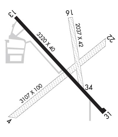
| Lat: N 3356.9 Long: W 09837.0 Elev: 1005 Var: -10 Longest Runway: 3320 | ||
| CTAF: 122.8 | ||
| ||||||
|
| Rwy | Rwy | |||||||
| 3107x100 | 3107' | 3107x100 | 3107' | |||||
| 3320x40 | 3320' | 3320x40 | 3320' | |||||
| 2037x42 | 2037' | 2037x42 | 2037' | |||||
| Runway ID | Single Wheel | Double Wheel | Double Tandem Wheel | Dual Double Wheel |
| 04/22 | N/A | N/A | N/A | N/A |
| 13/31 | 8,000 | 12,500 | N/A | N/A |
| 16/34 | N/A | N/A | N/A | N/A |
| These numbers are Advisory and are not limits. The Airport Manager should have more accurate Weight Limits | ||||
 Airport Diagram might not be current. | |
| Facility Name: | WICHITA VALLEY |
| City Name: | WICHITA FALLS |
| County: | WICHITA |
| State abbrev: | TX |
| State Name: | TEXAS |
| Ownership: | PRIVATELY OWNED |
| Use: | OPEN TO THE PUBLIC |
| Owner's Name: | JOHN HOOKER |
| Address: | 2926 HAWS ROAD |
| IOWA PARK, TX 76367 | |
| Owner's Phone: | 940-781-7246 |
| Manager's Name: | JOHN HOOKER |
| Address: | 2926 HAWS ROAD |
| IOWA PARK, TX 76367 | |
| Phone: | 940-781-7246 |
| FAA Region: | SOUTHWEST |
| FAA Field Office: | TEX |
| Date | Sunrise | Sunset |
|---|---|---|
| 09/24/21 Friday | 7:24 | 19:29 |
| 09/25/21 Saturday | 7:24 | 19:27 |
| 09/26/21 Sunday | 7:25 | 19:26 |
| 09/27/21 Monday | 7:26 | 19:25 |
| 09/28/21 Tuesday | 7:27 | 19:23 |
| 09/29/21 Wednesday | 7:27 | 19:22 |
| 09/30/21 Thursday | 7:28 | 19:20 |
| 10/01/21 Friday | 7:29 | 19:19 |
| 10/02/21 Saturday | 7:29 | 19:18 |
| 10/03/21 Sunday | 7:30 | 19:16 |
| 10/04/21 Monday | 7:31 | 19:15 |
| 10/05/21 Tuesday | 7:32 | 19:14 |
| 10/06/21 Wednesday | 7:32 | 19:12 |
| 10/07/21 Thursday | 7:33 | 19:11 |
| Airport Attendance Schedule | UNATTENDED |
| Airport Status | OPERATIONAL (This Status can change at any time - please check NOTAMS) |
| Airport Lighting Schedule | SS-SR |
| Airport Storage Available | Tie Downs, Hanger |
| Extra Services Available | Crop Dusting |
| Wind Indicator | YES - (unlit) |
| Control Tower | NO |
| CTAF Frequency | 122.800 |
| Unicom Frequency | 122.800 |
| Rotating Beacon Color | |
| Segmented Circle | NO |
| Landing Fee | NO |
| Airport Inspected | STATE - performed by STATE AERONAUTICAL PERSONNEL |
| Inspection Date | 12/20/2017 |
| Type of Fuel Available | Grade 100LL; -10SELF SVC FUEL AVBL 24 HRS WITH MAJOR CREDIT CARD. |
| Airframe Repair Service | None |
| Power Plant Repair Service | None |
| Latitude | N3356.9 |
| Longitude | W09837.0 (ESTIMATED) |
| Arpt Elevation | 1005ft (SURVEYED) |
| Magnetic Variation | 10E |
| 8 miles NW | of WICHITA FALLS |
| Traffic Pattern Altitude | |
| Sectional Chart | DALLAS-FT WORTH |
| Operations (Reported) | Yearly | Avg. Daily |
|---|---|---|
| General Aviation Transient | 1460 | 4 |
| General Aviation Local | 4380 | 12 |
| Air Taxi | 0 | 0 |
| Commerical | 0 | 0 |
| Commuter | 0 | 0 |
| Military | 0 | 0 |
| Aircraft based on Field | |
|---|---|
| General Aviation Singles | 60 |
| General Aviation Multi | 5 |
| Jet Aircraft | 0 |
| General Aviation Helicopters | 3 |
| Military Aircraft | 0 |
| Gliders | 0 |
| Ultralights | 2 |
| FSS on field | NO |
| FSS tie-in | FORT WORTH |
| FSS Phone | 1-800-WX-BRIEF |
| Who issues Notams | FTW |
| Notam D service at airport | YES |
| ARTCC Name | FORT WORTH |
| Airport Certification | |
| Aircraft Rescue & Firefighting Index | None |
| Airport of Entry | No |
| Custom Landing Rights | No |
| Joint Civil/Military | No |
| Military Landing rights | No |
| THIS AIRPORT HAS BEEN SURVEYED BY THE NATIONAL GEODETIC SURVEY. |
| INTENSIVE JET TRAINER TFC 2800-4500 FT MSL VICINITY OF ARPT & SHEPPARD AFB 6 MILES NE. CTC APCH CTL FOR TFC ADVISORIES. |
| FOR CD CTC FORT WORTH ARTCC AT 817-858-7584. |
| RWY 13/3 1 RY 13/31 NSTD LIRL. RY 13 THLD LGTS ARE 2 GREEN/RED; RY 31 THLD LGTS ARE 2 GREEN/RED OBSTN LGTS ON BANK ACROSS RY END. |
Airport Communications & Frequencies:
| |||||||||||||||||
| Runway: 04 | Runway: 22 | ||
| Mag heading: | 39° | Mag heading: | 219° |
| Rwy Slope: | .00% | Rwy Slope: | .00% |
| Approach: | Approach: | ||
| Pattern: | Left Traffic | Pattern: | Left Traffic |
| Markings: | Markings: | ||
| Marking Condition: | Marking Condition: | ||
| Arresting Dev: | Arresting Dev: | ||
| Lat & Long: | N3356.6 W09837.2 | Lat. & Long.: | N3357.0 W09836.7 |
| Elev: | 984.0 ft. MSL | Elev: | 984.0 ft. MSL |
| TCH: | TCH: | ||
| Visual Glide Path: | Visual Glide Path: | ||
| Displaced Threshold: | No | Displaced Threshold: | No |
| Touchdown Zone: | NO | Touchdown Zone: | NO |
| Touchdown Elev.: | Touchdown Elev.: | ||
| Visual Glide Slope: | Visual Glide Slope: | ||
| RVR Equipment: | RVR Equipment: | ||
| RVV Equipment: | NO | RVV Equipment: | NO |
| Approach Lights: | Approach Lights: | ||
| REIL: | NO | REIL: | NO |
| Centerline Lights: | NO | Centerline Lights: | NO |
| Touchdown lights: | NO | Touchdown lights: | NO |
| Runway Category: | Runway with a Visual Approach | Runway Category: | Runway with a Visual Approach |
| Declared Distances: | Declared Distances: | ||
| Obstructions: | PLINE | Obstructions: | TREES |
| Marked: | MARKED | Marked: | NOT Marked/Lighted |
| Clearance slope: | 1:1 | Clearance slope: | 2:1 |
| Obstruction height: | 34 feet AGL | Obstruction height: | 36 feet AGL |
| Dist. from runway: | 50 feet | Dist. from runway: | 90 feet |
| Centerline offset: | Centerline offset: | 155 feet left of centerline | |
| Comments: | Comments: |
| Runway: 13 | Runway: 31 | ||
| Mag heading: | 131° | Mag heading: | 311° |
| Rwy Slope: | -.69% Down | Rwy Slope: | .69% Up |
| Approach: | Approach: | ||
| Pattern: | Left Traffic | Pattern: | Left Traffic |
| Markings: | BASIC | Markings: | BASIC |
| Marking Condition: | GOOD; MARKINGS NSTD; NRS & CNTRLN SMALL. | Marking Condition: | GOOD; MARKINGS NSTD; NRS & CNTRLN SMALL. |
| Arresting Dev: | Arresting Dev: | ||
| Lat & Long: | N3357.1 W09837.2 | Lat. & Long.: | N3356.7 W09836.8 |
| Elev: | 1004.4 ft. MSL | Elev: | 981.5 ft. MSL |
| TCH: | TCH: | ||
| Visual Glide Path: | Visual Glide Path: | ||
| Displaced Threshold: | No | Displaced Threshold: | No |
| Touchdown Zone: | YES | Touchdown Zone: | YES |
| Touchdown Elev.: | 1005.1 feet | Touchdown Elev.: | 1004.6 feet |
| Visual Glide Slope: | Visual Glide Slope: | ||
| RVR Equipment: | RVR Equipment: | ||
| RVV Equipment: | NO | RVV Equipment: | NO |
| Approach Lights: | Approach Lights: | ||
| REIL: | NO | REIL: | NO |
| Centerline Lights: | NO | Centerline Lights: | NO |
| Touchdown lights: | NO | Touchdown lights: | NO |
| Runway Category: | Runway with a Visual Approach | Runway Category: | Runway with a Visual Approach |
| Declared Distances: | Declared Distances: | ||
| Obstructions: | ROAD | Obstructions: | TREE |
| Marked: | NOT Marked/Lighted | Marked: | NOT Marked/Lighted |
| Clearance slope: | Clearance slope: | 6:1 | |
| Obstruction height: | 15 feet AGL | Obstruction height: | 18 feet AGL |
| Dist. from runway: | 200 feet | Dist. from runway: | 319 feet |
| Centerline offset: | 80 right of centerline | Centerline offset: | 33 feet left of centerline |
| Comments: | 4 FT FENCE POSTS 60 FT FM THLD ACROSS APCH. 12 FT TREE 108 FT FM THLD 30 FT R. | Comments: | 6 FT BANK 50 FT FM THLD ACROSS APCH. 3 FT ISOLATED BRUSH ON BERM. |
| Runway: 16 | Runway: 34 | ||
| Mag heading: | 163° | Mag heading: | 343° |
| Rwy Slope: | .59% Up | Rwy Slope: | -.59% Down |
| Approach: | Approach: | ||
| Pattern: | Left Traffic | Pattern: | Left Traffic |
| Markings: | Markings: | ||
| Marking Condition: | Marking Condition: | ||
| Arresting Dev: | Arresting Dev: | ||
| Lat & Long: | N3357.1 W09836.9 | Lat. & Long.: | N3356.8 W09836.9 |
| Elev: | 983.0 ft. MSL | Elev: | 995.0 ft. MSL |
| TCH: | TCH: | ||
| Visual Glide Path: | Visual Glide Path: | ||
| Displaced Threshold: | No | Displaced Threshold: | No |
| Touchdown Zone: | NO | Touchdown Zone: | NO |
| Touchdown Elev.: | Touchdown Elev.: | ||
| Visual Glide Slope: | Visual Glide Slope: | ||
| RVR Equipment: | RVR Equipment: | ||
| RVV Equipment: | NO | RVV Equipment: | NO |
| Approach Lights: | Approach Lights: | ||
| REIL: | NO | REIL: | NO |
| Centerline Lights: | NO | Centerline Lights: | NO |
| Touchdown lights: | NO | Touchdown lights: | NO |
| Runway Category: | Runway with a Visual Approach | Runway Category: | Runway with a Visual Approach |
| Declared Distances: | Declared Distances: | ||
| Obstructions: | FENCE | Obstructions: | PLINE |
| Marked: | NOT Marked/Lighted | Marked: | LIGHTED |
| Clearance slope: | 20:1 | Clearance slope: | 33:1 |
| Obstruction height: | 4 feet AGL | Obstruction height: | 30 feet AGL |
| Dist. from runway: | 80 feet | Dist. from runway: | 1000 feet |
| Centerline offset: | Centerline offset: | ||
| Comments: | Comments: |
Thanks for using FltPlan.com
all rights reserved © 1999-2021 by Flight Plan LLC
