
| WILBARGER COUNTY VERNON TX |
| |
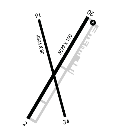
| Lat: N 3413.5 Long: W 09917.0 Elev: 1265 Var: -08 Longest Runway: 5099 | ||
| AWOS: 118.52 CTAF: 122.8 | ||
| ||||||||||||||||||||||||||||||||||||||||||||
| ||||||||||||||||||||||||||||||||||||||||||||
| ||||||||||||||||||||||||||||||||||||||||||||
| Rwy | Rwy | |||||||
| 5099x100 | 5099' | 5099x100 | 5099' | |||||
| 4304x80 | 4304' | 4304x80 | 4304' | |||||
| Runway ID | Single Wheel | Double Wheel | Double Tandem Wheel | Dual Double Wheel |
| 02/20 | 30,000 | 40,000 | 60,000 | N/A |
| 16/34 | 10,000 | N/A | N/A | N/A |
| These numbers are Advisory and are not limits. The Airport Manager should have more accurate Weight Limits | ||||
 Airport Diagram might not be current. | |
| Facility Name: | WILBARGER COUNTY |
| City Name: | VERNON |
| County: | WILBARGER |
| State abbrev: | TX |
| State Name: | TEXAS |
| Ownership: | PUBLICLY OWNED |
| Use: | OPEN TO THE PUBLIC |
| Owner's Name: | WILBARGER COUNTY |
| Address: | COUNTY COURTHOUSE, 1700 WILBARGER ST |
| VERNON, TX 76384 | |
| Owner's Phone: | 940-553-2300 |
| Manager's Name: | KYLE MILLER |
| Address: | 12557 HAMP NAYLOR DRIVE |
| VERNON, TX 76384 | |
| Phone: | 940-552-2182 |
| FAA Region: | SOUTHWEST |
| FAA Field Office: | TEX |
| Date | Sunrise | Sunset |
|---|---|---|
| 06/08/26 Monday | 6:25 | 20:48 |
| 06/09/26 Tuesday | 6:25 | 20:48 |
| 06/10/26 Wednesday | 6:25 | 20:48 |
| 06/11/26 Thursday | 6:25 | 20:49 |
| 06/12/26 Friday | 6:25 | 20:49 |
| 06/13/26 Saturday | 6:25 | 20:50 |
| 06/14/26 Sunday | 6:25 | 20:50 |
| 06/15/26 Monday | 6:25 | 20:50 |
| 06/16/26 Tuesday | 6:25 | 20:51 |
| 06/17/26 Wednesday | 6:25 | 20:51 |
| 06/18/26 Thursday | 6:25 | 20:51 |
| 06/19/26 Friday | 6:25 | 20:52 |
| 06/20/26 Saturday | 6:25 | 20:52 |
| 06/21/26 Sunday | 6:26 | 20:52 |
| Airport Attendance Schedule | MON-SAT 0800-1700 |
| Airport Status | OPERATIONAL (This Status can change at any time - please check NOTAMS) |
| Airport Lighting Schedule | MIRLS DUSK-DAWN. |
| Airport Storage Available | Tie Downs, Hanger |
| Extra Services Available | Crop Dusting, Flight Instruction |
| Wind Indicator | YES - (lighted) |
| Control Tower | NO |
| CTAF Frequency | 122.800 |
| Unicom Frequency | 122.800 |
| Rotating Beacon Color | WG |
| Segmented Circle | YES |
| Landing Fee | NO |
| Airport Inspected | STATE - performed by PRIVATE CONTRACT PERSONNEL |
| Inspection Date | 11/16/2023 |
| Type of Fuel Available | Grade 100LL, JET A; -10100 LL SELF-SERVE. 100LL, JET A+ FULL SERVE; AFT HRS SVC CALL 940-839-6365. |
| Airframe Repair Service | None |
| Power Plant Repair Service | None |
| Latitude | N3413.5 |
| Longitude | W09917.0 (ESTIMATED) |
| Arpt Elevation | 1264ft (SURVEYED) |
| Magnetic Variation | 08E |
| 4 miles N | of VERNON |
| Traffic Pattern Altitude | |
| Sectional Chart | DALLAS-FT WORTH |
| Operations (Reported) | Yearly | Avg. Daily |
|---|---|---|
| General Aviation Transient | 0 | 0 |
| General Aviation Local | 0 | 0 |
| Air Taxi | 0 | 0 |
| Commerical | 0 | 0 |
| Commuter | 0 | 0 |
| Military | 0 | 0 |
| Aircraft based on Field | |
|---|---|
| General Aviation Singles | 0 |
| General Aviation Multi | 0 |
| Jet Aircraft | 0 |
| General Aviation Helicopters | 0 |
| Military Aircraft | 0 |
| Gliders | 0 |
| Ultralights | 0 |
| FSS on field | NO |
| FSS tie-in | FORT WORTH |
| FSS Phone | 1-800-WX-BRIEF |
| Who issues Notams | F05 |
| Notam D service at airport | YES |
| ARTCC Name | FORT WORTH |
| Airport Certification | |
| Aircraft Rescue & Firefighting Index | None |
| Airport of Entry | No |
| Custom Landing Rights | No |
| Joint Civil/Military | No |
| Military Landing rights | YES |
| NATIONAL PLAN OF INTEGRATED AIRPORT SYSTEMS (NPIAS) |
| GRANT AGREEMENTS UNDER FAAP/ADAP/AIP |
| ASSURANCES PURSUANT TO TITLE VI, CIVIL RIGHTS ACT OF 1964 |
| AGREEMENT UNDER DLAND OR DCLA HAS EXPIRED. |
| THIS AIRPORT HAS BEEN SURVEYED BY THE NATIONAL GEODETIC SURVEY. |
| SEASONAL EXTSV AERIAL AG OPS. |
| FOR CD CTC FORT WORTH ARTCC AT 817-858-7584. |
| RWY 2/20 GRASS ENCROACHING 13 FT EACH SIDE |
Airport Communications & Frequencies:
| |||||||||||||||||
| Runway: 02 | Runway: 20 | ||
| Mag heading: | 24° | Mag heading: | 204° |
| Rwy Slope: | -.18% Down | Rwy Slope: | .18% Up |
| Approach: | Approach: | ||
| Pattern: | Left Traffic | Pattern: | Left Traffic |
| Markings: | NONPRECISION INSTRUMENT | Markings: | NONPRECISION INSTRUMENT |
| Marking Condition: | GOOD | Marking Condition: | GOOD |
| Arresting Dev: | Arresting Dev: | ||
| Lat & Long: | N3413.2 W09917.3 | Lat. & Long.: | N3413.9 W09916.7 |
| Elev: | 1264.4 ft. MSL | Elev: | 1255.3 ft. MSL |
| TCH: | TCH: | 25 ft. AGL | |
| Visual Glide Path: | Visual Glide Path: | 3.00 degrees | |
| Displaced Threshold: | No | Displaced Threshold: | No |
| Touchdown Zone: | YES | Touchdown Zone: | YES |
| Touchdown Elev.: | 1264.7 feet | Touchdown Elev.: | 1259.1 feet |
| Visual Glide Slope: | Visual Glide Slope: | 4-BOX VASI ON LEFT SIDE OF RUNWAY | |
| RVR Equipment: | RVR Equipment: | ||
| RVV Equipment: | NO | RVV Equipment: | NO |
| Approach Lights: | Approach Lights: | ||
| REIL: | NO | REIL: | NO |
| Centerline Lights: | NO | Centerline Lights: | NO |
| Touchdown lights: | NO | Touchdown lights: | NO |
| Runway Category: | Runway with a Non-precision Approach having visibility minimums greater than 3/4 mile | Runway Category: | Runway with a Non-precision Approach having visibility minimums greater than 3/4 mile |
| Declared Distances: | Declared Distances: | ||
| Obstructions: | ROAD | Obstructions: | ROAD |
| Marked: | NOT Marked/Lighted | Marked: | NOT Marked/Lighted |
| Clearance slope: | 34:1 | Clearance slope: | 41:1 |
| Obstruction height: | 15 feet AGL | Obstruction height: | 10 feet AGL |
| Dist. from runway: | 710 feet | Dist. from runway: | 617 feet |
| Centerline offset: | 295 right of centerline | Centerline offset: | 317 feet left of centerline |
| Comments: | Comments: |
| Runway: 16 | Runway: 34 | ||
| Mag heading: | 158° | Mag heading: | 338° |
| Rwy Slope: | .02% Up | Rwy Slope: | -.02% Down |
| Approach: | Approach: | ||
| Pattern: | Left Traffic | Pattern: | Left Traffic |
| Markings: | NONPRECISION INSTRUMENT | Markings: | NONPRECISION INSTRUMENT |
| Marking Condition: | GOOD | Marking Condition: | GOOD |
| Arresting Dev: | Arresting Dev: | ||
| Lat & Long: | N3413.9 W09917.2 | Lat. & Long.: | N3413.2 W09916.9 |
| Elev: | 1258.3 ft. MSL | Elev: | 1259.2 ft. MSL |
| TCH: | TCH: | ||
| Visual Glide Path: | Visual Glide Path: | ||
| Displaced Threshold: | No | Displaced Threshold: | No |
| Touchdown Zone: | YES | Touchdown Zone: | YES |
| Touchdown Elev.: | 1260.6 feet | Touchdown Elev.: | 1260.6 feet |
| Visual Glide Slope: | Visual Glide Slope: | ||
| RVR Equipment: | RVR Equipment: | ||
| RVV Equipment: | NO | RVV Equipment: | NO |
| Approach Lights: | Approach Lights: | ||
| REIL: | NO | REIL: | NO |
| Centerline Lights: | NO | Centerline Lights: | NO |
| Touchdown lights: | NO | Touchdown lights: | NO |
| Runway Category: | Runway with a Visual Approach | Runway Category: | Runway with a Visual Approach |
| Declared Distances: | Declared Distances: | ||
| Obstructions: | ROAD | Obstructions: | |
| Marked: | NOT Marked/Lighted | Marked: | |
| Clearance slope: | 19:1 | Clearance slope: | 50:1 |
| Obstruction height: | 12 feet AGL | Obstruction height: | |
| Dist. from runway: | 432 feet | Dist. from runway: | |
| Centerline offset: | Centerline offset: | ||
| Comments: | Comments: |
Thanks for using FltPlan.com
all rights reserved © 1999-2026 by Flight Plan LLC
