
| JONES FIELD BONHAM TX |
| |
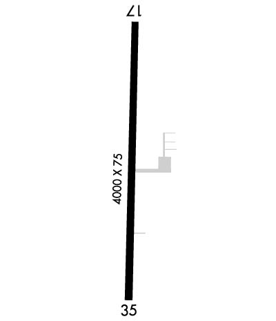
| Lat: N 3336.8 Long: W 09610.8 Elev: 618 Var: -06 Longest Runway: 4000 | ||
| CTAF: 122.8 | ||
| ||||||
|
| Rwy | Rwy | |||||||
| 4000x75 | 4000' | 4000x75 | 4000' | |||||
| Runway ID | Single Wheel | Double Wheel | Double Tandem Wheel | Dual Double Wheel |
| 17/35 | 12,500 | N/A | N/A | N/A |
| These numbers are Advisory and are not limits. The Airport Manager should have more accurate Weight Limits | ||||
 Airport Diagram might not be current. | |
| Facility Name: | JONES FLD |
| City Name: | BONHAM |
| County: | FANNIN |
| State abbrev: | TX |
| State Name: | TEXAS |
| Ownership: | PUBLICLY OWNED |
| Use: | OPEN TO THE PUBLIC |
| Owner's Name: | CITY OF BONHAM |
| Address: | 514 CHESTNUT |
| BONHAM, TX 75418 | |
| Owner's Phone: | 903-583-7555 |
| Manager's Name: | ZACK WHITLOCK; DIRECTOR OF PUBLIC WORKS. |
| Address: | 514 CHESTNUT |
| BONHAM, TX 75418 | |
| Phone: | 903-583-8623 |
| FAA Region: | SOUTHWEST |
| FAA Field Office: | TEX |
| Date | Sunrise | Sunset |
|---|---|---|
| 06/07/26 Sunday | 6:14 | 20:33 |
| 06/08/26 Monday | 6:14 | 20:34 |
| 06/09/26 Tuesday | 6:14 | 20:34 |
| 06/10/26 Wednesday | 6:14 | 20:34 |
| 06/11/26 Thursday | 6:14 | 20:35 |
| 06/12/26 Friday | 6:14 | 20:35 |
| 06/13/26 Saturday | 6:14 | 20:36 |
| 06/14/26 Sunday | 6:14 | 20:36 |
| 06/15/26 Monday | 6:14 | 20:36 |
| 06/16/26 Tuesday | 6:14 | 20:37 |
| 06/17/26 Wednesday | 6:14 | 20:37 |
| 06/18/26 Thursday | 6:14 | 20:37 |
| 06/19/26 Friday | 6:14 | 20:38 |
| 06/20/26 Saturday | 6:15 | 20:38 |
| Airport Attendance Schedule | UNATTENDED; FOR ARPT ATTENDANT CALL 903-583-7555 M-F 8:00-5:00. AFT HRS CALL BONHAM POLICE DEPT 903-583-2141. |
| Airport Status | OPERATIONAL (This Status can change at any time - please check NOTAMS) |
| Airport Lighting Schedule | MIRL RWY 17 & 35 SS-SR PRESET LOW; TO ACTVT OR INCR INTST - CTAF. PAPI RWY 17 & PAPI RWY 35 OPR CONSLY. |
| Airport Storage Available | Tie Downs |
| Extra Services Available | Crop Dusting |
| Wind Indicator | YES - (lighted) |
| Control Tower | NO |
| CTAF Frequency | 122.800 |
| Unicom Frequency | 122.800; UNICOM UNMONITORED. |
| Rotating Beacon Color | WG |
| Segmented Circle | YES |
| Landing Fee | NO |
| Airport Inspected | STATE - performed by PRIVATE CONTRACT PERSONNEL |
| Inspection Date | 05/10/2024 |
| Type of Fuel Available | Grade 100LL, JET A; -10100 LL SELF-SERV.; -A+JET A FULL SERV. CALL 903-227-5199. |
| Airframe Repair Service | MAJOR; FOR AIRFRAME REPAIRS CALL 903-640-0233 OR 903-583-5119. |
| Power Plant Repair Service | MAJOR |
| Latitude | N3336.8 |
| Longitude | W09610.8 (ESTIMATED) |
| Arpt Elevation | 618ft (SURVEYED) |
| Magnetic Variation | 06E |
| 2 miles N | of BONHAM |
| Traffic Pattern Altitude | |
| Sectional Chart | DALLAS-FT WORTH |
| Operations (Reported) | Yearly | Avg. Daily |
|---|---|---|
| General Aviation Transient | 0 | 0 |
| General Aviation Local | 0 | 0 |
| Air Taxi | 0 | 0 |
| Commerical | 0 | 0 |
| Commuter | 0 | 0 |
| Military | 0 | 0 |
| Aircraft based on Field | |
|---|---|
| General Aviation Singles | 0 |
| General Aviation Multi | 0 |
| Jet Aircraft | 0 |
| General Aviation Helicopters | 0 |
| Military Aircraft | 0 |
| Gliders | 0 |
| Ultralights | 0 |
| FSS on field | NO |
| FSS tie-in | FORT WORTH |
| FSS Phone | 1-800-WX-BRIEF |
| Who issues Notams | FTW |
| Notam D service at airport | YES |
| ARTCC Name | FORT WORTH |
| Airport Certification | |
| Aircraft Rescue & Firefighting Index | None |
| Airport of Entry | No |
| Custom Landing Rights | No |
| Joint Civil/Military | No |
| Military Landing rights | YES |
| NATIONAL PLAN OF INTEGRATED AIRPORT SYSTEMS (NPIAS) |
| GRANT AGREEMENTS UNDER FAAP/ADAP/AIP |
| SURPLUS PROPERTY AGREEMENT UNDER REGULATION 16-WAA |
| ASSURANCES PURSUANT TO TITLE VI, CIVIL RIGHTS ACT OF 1964 |
| FOR CD CTC FORT WORTH ARTCC AT 817-858-7584. |
| EXTSV AERIAL AG OPS APR-AUG. OTR TIMES IREG. |
Airport Communications & Frequencies:
| |||||||||
| Runway: 17 | Runway: 35 | ||
| Mag heading: | 176° | Mag heading: | 356° |
| Rwy Slope: | -.14% Down | Rwy Slope: | .14% Up |
| Approach: | Approach: | ||
| Pattern: | Left Traffic | Pattern: | Left Traffic |
| Markings: | NONPRECISION INSTRUMENT | Markings: | NONPRECISION INSTRUMENT |
| Marking Condition: | GOOD | Marking Condition: | GOOD |
| Arresting Dev: | Arresting Dev: | ||
| Lat & Long: | N3337.1 W09610.7 | Lat. & Long.: | N3336.5 W09610.8 |
| Elev: | 617.9 ft. MSL | Elev: | 612.3 ft. MSL |
| TCH: | 37 ft. AGL | TCH: | 37 ft. AGL |
| Visual Glide Path: | 3.00 degrees | Visual Glide Path: | 3.00 degrees |
| Displaced Threshold: | No | Displaced Threshold: | No |
| Touchdown Zone: | YES | Touchdown Zone: | YES |
| Touchdown Elev.: | 618.2 feet | Touchdown Elev.: | 618.2 feet |
| Visual Glide Slope: | 2-Light PAPI on LEFT side of Runway | Visual Glide Slope: | 2-Light PAPI on LEFT side of Runway |
| RVR Equipment: | RVR Equipment: | ||
| RVV Equipment: | NO | RVV Equipment: | NO |
| Approach Lights: | Approach Lights: | ||
| REIL: | NO | REIL: | NO |
| Centerline Lights: | NO | Centerline Lights: | NO |
| Touchdown lights: | NO | Touchdown lights: | NO |
| Runway Category: | Runway with a Non-precision Approach | Runway Category: | Runway with a Non-precision Approach |
| Declared Distances: | Declared Distances: | ||
| Obstructions: | TREES; ALSO 43 FT PLINE, 1315 FT DSTC, 225 L/R, 25:1. | Obstructions: | ANT |
| Marked: | NOT Marked/Lighted | Marked: | NOT Marked/Lighted |
| Clearance slope: | 15:1 | Clearance slope: | 12:1 |
| Obstruction height: | 22 feet AGL | Obstruction height: | 18 feet AGL |
| Dist. from runway: | 540 feet | Dist. from runway: | 425 feet |
| Centerline offset: | 260 right of centerline | Centerline offset: | 175 feet left of centerline |
| Comments: | Comments: | 33 FT TREES, 0-50 FT DSTC, 239 FT L; 4 FT FENCE, 0-100 FT DSTC, 190 FT L. |
Thanks for using FltPlan.com
all rights reserved © 1999-2026 by Flight Plan LLC
