| CAMERON MEMORIAL CAMERON MO |
| |
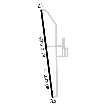
| Lat: N 3943.7 Long: W 09416.6 Elev: 1040 Var: -03 Longest Runway: 4000 | ||
| Clr Del: 121.6 CTAF: 122.8 | ||
| ||||||||||||||||||||||||||||||
| ||||||||||||||||||||||||||||||
| Rwy | Rwy | |||||||
| 4000x75 | 4000' | 4000x75 | 4000' | |||||
| Runway ID | Single Wheel | Double Wheel | Double Tandem Wheel | Dual Double Wheel |
| 17/35 | 30,000 | N/A | N/A | N/A |
| These numbers are Advisory and are not limits. The Airport Manager should have more accurate Weight Limits | ||||
 Airport Diagram might not be current. | |
| Facility Name: | CAMERON MEML |
| City Name: | CAMERON |
| County: | CLINTON |
| State abbrev: | MO |
| State Name: | MISSOURI |
| Ownership: | PUBLICLY OWNED |
| Use: | OPEN TO THE PUBLIC |
| Owner's Name: | CITY OF CAMERON |
| Address: | 205 NORTH MAIN |
| CAMERON, MO 64429 | |
| Owner's Phone: | 816-632-2177 |
| Manager's Name: | ERIC EVANS |
| Address: | 11766 NORTHEAST A HWY |
| CAMERON, MO 64429 | |
| Phone: | 816-632-2423 |
| FAA Region: | CENTRAL |
| FAA Field Office: | NONE |
| Date | Sunrise | Sunset |
|---|---|---|
| 06/08/26 Monday | 5:49 | 20:43 |
| 06/09/26 Tuesday | 5:49 | 20:44 |
| 06/10/26 Wednesday | 5:49 | 20:44 |
| 06/11/26 Thursday | 5:49 | 20:45 |
| 06/12/26 Friday | 5:49 | 20:45 |
| 06/13/26 Saturday | 5:48 | 20:46 |
| 06/14/26 Sunday | 5:48 | 20:46 |
| 06/15/26 Monday | 5:48 | 20:47 |
| 06/16/26 Tuesday | 5:49 | 20:47 |
| 06/17/26 Wednesday | 5:49 | 20:47 |
| 06/18/26 Thursday | 5:49 | 20:48 |
| 06/19/26 Friday | 5:49 | 20:48 |
| 06/20/26 Saturday | 5:49 | 20:48 |
| 06/21/26 Sunday | 5:49 | 20:48 |
| Airport Attendance Schedule | MON-FRI 0900-1700, SAT IREG |
| Airport Status | OPERATIONAL (This Status can change at any time - please check NOTAMS) |
| Airport Lighting Schedule | MIRL RY 17/35, PAPI RYS 17 & 35, REIL RYS 17 & 35 OPER DUSK-2400; AFT 2400 ACTVT & INCR INTS - CTAF. |
| Airport Storage Available | Tie Downs, Hanger |
| Extra Services Available | Flight Instruction, Aircraft Rental, Aircraft Sales |
| Wind Indicator | YES - (lighted) |
| Control Tower | NO |
| CTAF Frequency | 122.800 |
| Unicom Frequency | 122.800 |
| Rotating Beacon Color | WG |
| Segmented Circle | YES |
| Landing Fee | NO |
| Airport Inspected | STATE - performed by STATE AERONAUTICAL PERSONNEL |
| Inspection Date | 06/24/2024 |
| Type of Fuel Available | Grade 100LL; -10AUTOMATED SELF FUEL AVBL 24 HRS. |
| Airframe Repair Service | None |
| Power Plant Repair Service | None |
| Latitude | N3943.7 |
| Longitude | W09416.6 (ESTIMATED) |
| Arpt Elevation | 1040ft (SURVEYED) |
| Magnetic Variation | 03E |
| 2 miles SW | of CAMERON |
| Traffic Pattern Altitude | |
| Sectional Chart | KANSAS CITY |
| Operations (Reported) | Yearly | Avg. Daily |
|---|---|---|
| General Aviation Transient | 0 | 0 |
| General Aviation Local | 0 | 0 |
| Air Taxi | 0 | 0 |
| Commerical | 0 | 0 |
| Commuter | 0 | 0 |
| Military | 0 | 0 |
| Aircraft based on Field | |
|---|---|
| General Aviation Singles | 0 |
| General Aviation Multi | 0 |
| Jet Aircraft | 0 |
| General Aviation Helicopters | 0 |
| Military Aircraft | 0 |
| Gliders | 0 |
| Ultralights | 0; ULTRALIGHT ACTVTY ON & INVOF ARPT. |
| FSS on field | NO |
| FSS tie-in | COLUMBIA |
| FSS Phone | 1-800-WX-BRIEF |
| Who issues Notams | COU |
| Notam D service at airport | YES |
| ARTCC Name | KANSAS CITY |
| Airport Certification | |
| Aircraft Rescue & Firefighting Index | None |
| Airport of Entry | No |
| Custom Landing Rights | No |
| Joint Civil/Military | No |
| Military Landing rights | No |
| NATIONAL PLAN OF INTEGRATED AIRPORT SYSTEMS (NPIAS) |
| GRANT AGREEMENTS UNDER FAAP/ADAP/AIP |
| ASSURANCES PURSUANT TO TITLE VI, CIVIL RIGHTS ACT OF 1964 |
| FOR CD CTC KANSAS CITY APCH AT 816-329-2710. |
Airport Communications & Frequencies:
| ||||||||||||||||
| Runway: 17 | Runway: 35 | ||
| Mag heading: | 172° | Mag heading: | 352° |
| Rwy Slope: | -.42% Down | Rwy Slope: | .42% Up |
| Approach: | Approach: | ||
| Pattern: | Left Traffic | Pattern: | Left Traffic |
| Markings: | NONPRECISION INSTRUMENT | Markings: | NONPRECISION INSTRUMENT |
| Marking Condition: | GOOD | Marking Condition: | GOOD |
| Arresting Dev: | Arresting Dev: | ||
| Lat & Long: | N3944.0 W09416.6 | Lat. & Long.: | N3943.3 W09416.5 |
| Elev: | 1040.1 ft. MSL | Elev: | 1023.1 ft. MSL |
| TCH: | 21 ft. AGL | TCH: | 22 ft. AGL |
| Visual Glide Path: | 3.00 degrees | Visual Glide Path: | 3.00 degrees |
| Displaced Threshold: | No | Displaced Threshold: | No |
| Touchdown Zone: | YES | Touchdown Zone: | YES |
| Touchdown Elev.: | 1040.1 feet | Touchdown Elev.: | 1034.6 feet |
| Visual Glide Slope: | 4-Light PAPI on LEFT side of Runway | Visual Glide Slope: | 4-Light PAPI on LEFT side of Runway |
| RVR Equipment: | RVR Equipment: | ||
| RVV Equipment: | NO | RVV Equipment: | NO |
| Approach Lights: | Approach Lights: | ||
| REIL: | YES | REIL: | YES |
| Centerline Lights: | NO | Centerline Lights: | NO |
| Touchdown lights: | NO | Touchdown lights: | NO |
| Runway Category: | Runway with a Non-precision Approach having visibility minimums greater than 3/4 mile | Runway Category: | Runway with a Non-precision Approach having visibility minimums greater than 3/4 mile |
| Declared Distances: | Declared Distances: | ||
| Obstructions: | TREES | Obstructions: | |
| Marked: | NOT Marked/Lighted | Marked: | |
| Clearance slope: | 26:1 | Clearance slope: | 34:1 |
| Obstruction height: | 39 feet AGL | Obstruction height: | |
| Dist. from runway: | 1234 feet | Dist. from runway: | |
| Centerline offset: | 310 left of centerline | Centerline offset: | |
| Comments: | Comments: |
Thanks for using FltPlan.com
all rights reserved © 1999-2026 by Flight Plan LLC