
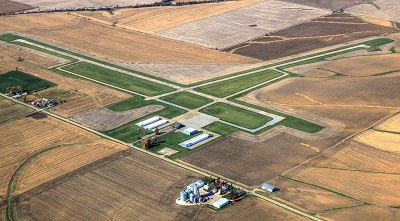
| KEWANEE MUNI KEWANEE IL |
| |
| Lat: N 4112.3 Long: W 08957.8 Elev: 858 Var: +02 Longest Runway: 4500 | ||
| CTAF: 122.8 | ||
| ||||||||||||||||||||||||||||||||
| ||||||||||||||||||||||||||||||||
| ||||||||||||||||||||||||||||||||
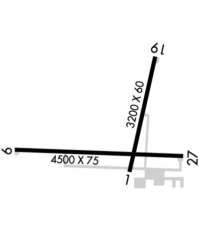
| Rwy | Rwy | |||||||
| 3200x60 | 3200' | 3200x60 | 3200' | |||||
| 4500x75 | 4500' | 4500x75 | 4500' | |||||
| Runway ID | Single Wheel | Double Wheel | Double Tandem Wheel | Dual Double Wheel |
| 01/19 | 20,000 | N/A | N/A | N/A |
| 09/27 | 20,000 | N/A | N/A | N/A |
| These numbers are Advisory and are not limits. The Airport Manager should have more accurate Weight Limits | ||||
 Airport Diagram might not be current. | |
| Facility Name: | KEWANEE MUNI |
| City Name: | KEWANEE |
| County: | HENRY |
| State abbrev: | IL |
| State Name: | ILLINOIS |
| Ownership: | PUBLICLY OWNED |
| Use: | OPEN TO THE PUBLIC |
| Owner's Name: | KEWANEE AIRPORT AUTHORITY |
| Address: | 3769 MIDLAND RD |
| KEWANEE, IL 61443 | |
| Owner's Phone: | 309-853-8671 |
| Manager's Name: | ROSS CARBIENER |
| Address: | 3769 MIDLAND RD. |
| KEWANEE, IL 61443 | |
| Phone: | 309-853-8671 |
| FAA Region: | GREAT LAKES |
| FAA Field Office: | CHI |
| Date | Sunrise | Sunset |
|---|---|---|
| 06/12/26 Friday | 5:26 | 20:33 |
| 06/13/26 Saturday | 5:26 | 20:33 |
| 06/14/26 Sunday | 5:26 | 20:34 |
| 06/15/26 Monday | 5:26 | 20:34 |
| 06/16/26 Tuesday | 5:26 | 20:35 |
| 06/17/26 Wednesday | 5:26 | 20:35 |
| 06/18/26 Thursday | 5:27 | 20:35 |
| 06/19/26 Friday | 5:27 | 20:36 |
| 06/20/26 Saturday | 5:27 | 20:36 |
| 06/21/26 Sunday | 5:27 | 20:36 |
| 06/22/26 Monday | 5:27 | 20:36 |
| 06/23/26 Tuesday | 5:28 | 20:36 |
| 06/24/26 Wednesday | 5:28 | 20:37 |
| 06/25/26 Thursday | 5:28 | 20:37 |
| Airport Attendance Schedule | MON-FRI 0800-1800, SAT 0900-1700, SUN 0900-1700 |
| Airport Status | OPERATIONAL (This Status can change at any time - please check NOTAMS) |
| Airport Lighting Schedule | MIRL RY 09/27 PRESET ON LOW INTST; TO INCR INTST & ACTVT MIRL RY 01/19 & TWY LGTS - CTAF. |
| Airport Storage Available | Tie Downs, Hanger |
| Extra Services Available | NONE |
| Wind Indicator | YES - (lighted) |
| Control Tower | NO |
| CTAF Frequency | 122.800 |
| Unicom Frequency | 122.800 |
| Rotating Beacon Color | WG |
| Segmented Circle | YES |
| Landing Fee | NO |
| Airport Inspected | STATE - performed by STATE AERONAUTICAL PERSONNEL |
| Inspection Date | 07/07/2023 |
| Type of Fuel Available | Grade 100LL; -1024 HR FUEL AVBL WITH CREDIT CARD. |
| Airframe Repair Service | MAJOR |
| Power Plant Repair Service | MAJOR |
| Latitude | N4112.3 |
| Longitude | W08957.8 (ESTIMATED) |
| Arpt Elevation | 858ft (SURVEYED) |
| Magnetic Variation | 02W |
| 3 miles SW | of KEWANEE |
| Traffic Pattern Altitude | 400; TPA: 400 FT AGL ULTRALIGHT. |
| Sectional Chart | CHICAGO |
| Operations (Reported) | Yearly | Avg. Daily |
|---|---|---|
| General Aviation Transient | 0 | 0 |
| General Aviation Local | 0 | 0 |
| Air Taxi | 0 | 0 |
| Commerical | 0 | 0 |
| Commuter | 0 | 0 |
| Military | 0 | 0 |
| Aircraft based on Field | |
|---|---|
| General Aviation Singles | 0 |
| General Aviation Multi | 0 |
| Jet Aircraft | 0 |
| General Aviation Helicopters | 0 |
| Military Aircraft | 0 |
| Gliders | 0 |
| Ultralights | 0 |
| FSS on field | NO |
| FSS tie-in | KANKAKEE |
| FSS Phone | 1-800-WX-BRIEF |
| Who issues Notams | IKK |
| Notam D service at airport | YES |
| ARTCC Name | CHICAGO |
| Airport Certification | |
| Aircraft Rescue & Firefighting Index | None |
| Airport of Entry | No |
| Custom Landing Rights | No |
| Joint Civil/Military | No |
| Military Landing rights | YES |
| NATIONAL PLAN OF INTEGRATED AIRPORT SYSTEMS (NPIAS) |
| GRANT AGREEMENTS UNDER FAAP/ADAP/AIP |
| ASSURANCES PURSUANT TO TITLE VI, CIVIL RIGHTS ACT OF 1964 |
| THIS AIRPORT HAS BEEN SURVEYED BY THE NATIONAL GEODETIC SURVEY. |
| ULTRALIGHT ACTIVITY ON & INVOF ARPT. |
| HOSPITAL HELIPORT 1.2 NM NORTHEAST OF ARPT. |
| FOR CD CTC CHICAGO ARTCC AT 630-906-8921. |
| AUTOMATED WX ADZY AVBL ON CTAF - 4 MIC CLICKS TO ACTVT. 5 CLICKS IS ABBREIATED "WIND ONLY" |
Airport Communications & Frequencies:
| |||||||||||||||||
| Runway: 01 | Runway: 19 | ||
| Mag heading: | 13° | Mag heading: | 193° |
| Rwy Slope: | -.55% Down | Rwy Slope: | .55% Up |
| Approach: | Approach: | ||
| Pattern: | Left Traffic | Pattern: | Left Traffic |
| Markings: | NONPRECISION INSTRUMENT | Markings: | NONPRECISION INSTRUMENT |
| Marking Condition: | GOOD | Marking Condition: | GOOD |
| Arresting Dev: | Arresting Dev: | ||
| Lat & Long: | N4112.2 W08957.8 | Lat. & Long.: | N4112.7 W08957.6 |
| Elev: | 855.1 ft. MSL | Elev: | 837.6 ft. MSL |
| TCH: | TCH: | ||
| Visual Glide Path: | Visual Glide Path: | ||
| Displaced Threshold: | No | Displaced Threshold: | No |
| Touchdown Zone: | YES | Touchdown Zone: | YES |
| Touchdown Elev.: | 856.9 feet | Touchdown Elev.: | 856.9 feet |
| Visual Glide Slope: | Visual Glide Slope: | ||
| RVR Equipment: | RVR Equipment: | ||
| RVV Equipment: | NO | RVV Equipment: | NO |
| Approach Lights: | Approach Lights: | ||
| REIL: | NO | REIL: | NO |
| Centerline Lights: | NO | Centerline Lights: | NO |
| Touchdown lights: | NO | Touchdown lights: | NO |
| Runway Category: | Runway with a Non-precision Approach | Runway Category: | Runway with a Non-precision Approach |
| Declared Distances: | Declared Distances: |
| Runway: 09 | Runway: 27 | ||
| Mag heading: | 93° | Mag heading: | 273° |
| Rwy Slope: | .06% Up | Rwy Slope: | -.06% Down |
| Approach: | Approach: | ||
| Pattern: | Left Traffic | Pattern: | Left Traffic |
| Markings: | NONPRECISION INSTRUMENT | Markings: | NONPRECISION INSTRUMENT |
| Marking Condition: | GOOD | Marking Condition: | GOOD |
| Arresting Dev: | Arresting Dev: | ||
| Lat & Long: | N4112.2 W08958.4 | Lat. & Long.: | N4112.2 W08957.4 |
| Elev: | 853.8 ft. MSL | Elev: | 856.3 ft. MSL |
| TCH: | 27 ft. AGL | TCH: | 23 ft. AGL |
| Visual Glide Path: | 3.50 degrees | Visual Glide Path: | 3.00 degrees |
| Displaced Threshold: | No | Displaced Threshold: | No |
| Touchdown Zone: | YES | Touchdown Zone: | YES |
| Touchdown Elev.: | 855.5 feet | Touchdown Elev.: | 858.0 feet |
| Visual Glide Slope: | PULSATING/STEADY BURNING VASI ON LEFT SIDE OF RUNWAY; RY 09 PVASI UNUSBL BYD 6 DEG LEFT AND RIGHT OF CNTRLN. | Visual Glide Slope: | PULSATING/STEADY BURNING VASI ON LEFT SIDE OF RUNWAY; RY 27 PVASI UNUSBL BYD 6 DEG LEFT AND RIGHT OF CNTRLN. |
| RVR Equipment: | RVR Equipment: | ||
| RVV Equipment: | NO | RVV Equipment: | NO |
| Approach Lights: | Approach Lights: | ||
| REIL: | NO | REIL: | NO |
| Centerline Lights: | NO | Centerline Lights: | NO |
| Touchdown lights: | NO | Touchdown lights: | NO |
| Runway Category: | Runway with a Non-precision Approach having visibility minimums greater than 3/4 mile | Runway Category: | Runway with a Non-precision Approach having visibility minimums greater than 3/4 mile |
| Declared Distances: | Declared Distances: |
Thanks for using FltPlan.com
all rights reserved © 1999-2026 by Flight Plan LLC