
| WEISER AIR PARK HOUSTON TX |
| |
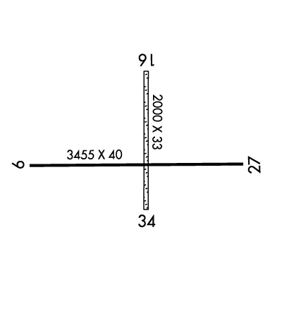
| Lat: N 2956.1 Long: W 09538.4 Elev: 137 Var: -06 Longest Runway: 3455 | ||
| CTAF: 122.8 | ||
| ||||||||||||||||||||||||||||||||||||||||||||
| ||||||||||||||||||||||||||||||||||||||||||||
| Rwy | Rwy | |||||||
| 3455x40 | 3455' | 3455x40 | 3455' | |||||
| 2000x33 | 2000' | 2000x33 | 2000' | |||||
| Runway ID | Single Wheel | Double Wheel | Double Tandem Wheel | Dual Double Wheel |
| 09/27 | 10,000 | N/A | N/A | N/A |
| 16/34 | 4,000 | N/A | N/A | N/A |
| These numbers are Advisory and are not limits. The Airport Manager should have more accurate Weight Limits | ||||
| FltPlan does not have IFR approach charts available for KEYQ. |
 Airport Diagram might not be current. | |
| Facility Name: | WEISER AIR PARK |
| City Name: | HOUSTON |
| County: | HARRIS |
| State abbrev: | TX |
| State Name: | TEXAS |
| Ownership: | PRIVATELY OWNED |
| Use: | OPEN TO THE PUBLIC |
| Owner's Name: | CECIL & ROBERT WEISER |
| Address: | 10818 HUFFMEISTER |
| HOUSTON, TX 77065 | |
| Owner's Phone: | 281-469-8227 |
| Manager's Name: | CECIL & ROBERT WEISER |
| Address: | 21904 HEMPSTEAD HWY |
| CYPRESS, TX 77429 | |
| Phone: | 281-469-8227 |
| FAA Region: | SOUTHWEST |
| FAA Field Office: | TEX |
| Date | Sunrise | Sunset |
|---|---|---|
| 06/06/20 Saturday | 6:21 | 20:22 |
| 06/07/20 Sunday | 6:21 | 20:22 |
| 06/08/20 Monday | 6:21 | 20:23 |
| 06/09/20 Tuesday | 6:21 | 20:23 |
| 06/10/20 Wednesday | 6:21 | 20:23 |
| 06/11/20 Thursday | 6:21 | 20:24 |
| 06/12/20 Friday | 6:21 | 20:24 |
| 06/13/20 Saturday | 6:21 | 20:25 |
| 06/14/20 Sunday | 6:21 | 20:25 |
| 06/15/20 Monday | 6:21 | 20:25 |
| 06/16/20 Tuesday | 6:21 | 20:26 |
| 06/17/20 Wednesday | 6:22 | 20:26 |
| 06/18/20 Thursday | 6:22 | 20:26 |
| 06/19/20 Friday | 6:22 | 20:26 |
| Airport Attendance Schedule | 7 Days A Week 0800-1700 |
| Airport Status | CLOSED INDEFINITELY (This Status can change at any time - please check NOTAMS) |
| Airport Lighting Schedule | SS-SR |
| Airport Storage Available | Tie Downs |
| Extra Services Available | Charter, Flight Instruction, Aircraft Rental |
| Wind Indicator | YES - (unlit) |
| Control Tower | NO |
| CTAF Frequency | 122.800 |
| Unicom Frequency | 122.800 |
| Rotating Beacon Color | CLEAR-GREEN (Light Land Airport) |
| Segmented Circle | NO |
| Landing Fee |
| Airport Inspected | STATE - performed by PRIVATE CONTRACT PERSONNEL |
| Inspection Date | 02/14/2017 |
| Type of Fuel Available | Grade 100LL; 100LL SELF SERVE WITH MAJOR CREDIT CARD. |
| Airframe Repair Service | MAJOR |
| Power Plant Repair Service | MAJOR |
| Latitude | N2956.1 |
| Longitude | W09538.4 (ESTIMATED) |
| Arpt Elevation | 137ft (SURVEYED) |
| Magnetic Variation | 06E |
| 11 miles NW | of HOUSTON |
| Traffic Pattern Altitude | |
| Sectional Chart | HOUSTON |
| Operations (Reported) | Yearly | Avg. Daily |
|---|---|---|
| General Aviation Transient | 2000 | 5 |
| General Aviation Local | 36000 | 99 |
| Air Taxi | 0 | 0 |
| Commerical | 0 | 0 |
| Commuter | 0 | 0 |
| Military | 0 | 0 |
| Aircraft based on Field | |
|---|---|
| General Aviation Singles | 70 |
| General Aviation Multi | 5 |
| Jet Aircraft | 0 |
| General Aviation Helicopters | 3 |
| Military Aircraft | 0 |
| Gliders | 0 |
| Ultralights | 0 |
| FSS on field | NO |
| FSS tie-in | MONTGOMERY COUNTY |
| FSS Phone | 1-800-WX-BRIEF |
| Who issues Notams | CXO |
| Notam D service at airport | YES |
| ARTCC Name | HOUSTON |
| Airport Certification | |
| Aircraft Rescue & Firefighting Index | None |
| Airport of Entry | No |
| Custom Landing Rights | No |
| Joint Civil/Military | No |
| Military Landing rights | No |
| HELICOPTER OPNS RESTRICTED TO AN AREA NW OF THE INTERSECTION OF RYS 09/27 AND 16/34. |
| (A89) FOR FP FILING CALL CXO FSS 1-800-992-7433. |
| RY 09/27 50 FT PLINE PARALLEL TO RY 300 FT NORTH. |
| FOR CD CTC HOUSTON APCH AT 281-443-5844 TO CNL IFR CALL 281-443-5888. |
| (ARPT STATUS) ARPT CLSD INDEFLY. |
| RWY 16/3 4 RY ROUGH WITH HOLES & DIRT MOUNDS. RY SOFT WHEN WET. |
| RWY 09/2 7 NSTD LIRL. NORTH SIDE LGTS 30 FT FM RY EDGE; SOUTH SIDE LGTS 40 FT FM RY EDGE; NSTD COLORS & LAYOUT. NO LIGHTS WEST END, SOUTH SIDE. |
Airport Communications & Frequencies:
| ||||||||||||||
| Runway: 09 | Runway: 27 | ||
| Mag heading: | 84° | Mag heading: | 264° |
| Rwy Slope: | -.10% Down | Rwy Slope: | .10% Up |
| Approach: | Approach: | ||
| Pattern: | Right Traffic | Pattern: | Left Traffic |
| Markings: | NONSTANDARD | Markings: | NONSTANDARD |
| Marking Condition: | FAIR; RY 09/27 NSTD CONFIGURATION: NRS ARE 17 FT TALL & 14 FT WIDE. STRIPES ARE 6 INCH WIDE BY 40 FT LONG WITH 25 FT SPACING. | Marking Condition: | FAIR |
| Arresting Dev: | Arresting Dev: | ||
| Lat & Long: | N2956.1 W09538.7 | Lat. & Long.: | N2956.1 W09538.0 |
| Elev: | 137.1 ft. MSL | Elev: | 133.5 ft. MSL |
| TCH: | TCH: | ||
| Visual Glide Path: | Visual Glide Path: | ||
| Displaced Threshold: | No | Displaced Threshold: | No |
| Touchdown Zone: | YES | Touchdown Zone: | YES |
| Touchdown Elev.: | 137.2 feet | Touchdown Elev.: | 136.6 feet |
| Visual Glide Slope: | Visual Glide Slope: | ||
| RVR Equipment: | RVR Equipment: | ||
| RVV Equipment: | NO | RVV Equipment: | NO |
| Approach Lights: | Approach Lights: | ||
| REIL: | YES | REIL: | YES |
| Centerline Lights: | NO | Centerline Lights: | NO |
| Touchdown lights: | NO | Touchdown lights: | NO |
| Runway Category: | Runway with a Visual Approach | Runway Category: | Runway with a Visual Approach |
| Declared Distances: | Declared Distances: | ||
| Obstructions: | TREE | Obstructions: | PLINE |
| Marked: | NOT Marked/Lighted | Marked: | NOT Marked/Lighted |
| Clearance slope: | 1:1 | Clearance slope: | 29:1 |
| Obstruction height: | 35 feet AGL | Obstruction height: | 38 feet AGL |
| Dist. from runway: | 201 feet | Dist. from runway: | 1302 feet |
| Centerline offset: | 60 right of centerline | Centerline offset: | |
| Comments: | +6 FT FENCE & 15 FT BRUSH 156 FT FM THLD. | Comments: | +4 FT FENCE 135 FT DSTC; 25 FT TREES 96 FT R EXTDD CNTRLN 135 FT DSTC; & 10 FT TREES 135 FT DSTC, BOTH SIDES OF RY CNTRLN. |
| Runway: 16 | Runway: 34 | ||
| Mag heading: | 166° | Mag heading: | 346° |
| Rwy Slope: | .00% | Rwy Slope: | .00% |
| Approach: | Approach: | ||
| Pattern: | Left Traffic | Pattern: | Left Traffic |
| Markings: | NONE | Markings: | NONE |
| Marking Condition: | POOR | Marking Condition: | POOR |
| Arresting Dev: | Arresting Dev: | ||
| Lat & Long: | N2956.3 W09538.4 | Lat. & Long.: | N2956.0 W09538.3 |
| Elev: | 137.2 ft. MSL | Elev: | 137.2 ft. MSL |
| TCH: | TCH: | ||
| Visual Glide Path: | Visual Glide Path: | ||
| Displaced Threshold: | No | Displaced Threshold: | No |
| Touchdown Zone: | YES | Touchdown Zone: | YES |
| Touchdown Elev.: | 137.2 feet | Touchdown Elev.: | 137.2 feet |
| Visual Glide Slope: | Visual Glide Slope: | ||
| RVR Equipment: | RVR Equipment: | ||
| RVV Equipment: | NO | RVV Equipment: | NO |
| Approach Lights: | Approach Lights: | ||
| REIL: | NO | REIL: | NO |
| Centerline Lights: | NO | Centerline Lights: | NO |
| Touchdown lights: | NO | Touchdown lights: | NO |
| Runway Category: | Runway with a Visual Approach | Runway Category: | Runway with a Visual Approach |
| Declared Distances: | Declared Distances: | ||
| Obstructions: | TREES | Obstructions: | TREE |
| Marked: | NOT Marked/Lighted | Marked: | NOT Marked/Lighted |
| Clearance slope: | Clearance slope: | ||
| Obstruction height: | 50 feet AGL | Obstruction height: | 50 feet AGL |
| Dist. from runway: | 0 feet | Dist. from runway: | 75 feet |
| Centerline offset: | Centerline offset: | 15 feet right of centerline | |
| Comments: | Comments: |
Thanks for using FltPlan.com
all rights reserved © 1999-2020 by Flight Plan LLC
