
| EAGLE CREEK AIRPARK INDIANAPOLIS IN |
| |
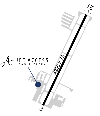
| Lat: N 3949.8 Long: W 08617.7 Elev: 823 Var: +05 Longest Runway: 4200 | ||
| Clr Del: 128.6 AWOS: 121.57 CTAF: 122.8 | ||
| |||||||||||||||||||||||||||||||
| |||||||||||||||||||||||||||||||
| |||||||||||||||||||||||||||||||
| FBOs at nearby airports who want your business: | |||||||||||||||||
| |||||||||||||||||
| Rwy | Rwy | |||||||
| 4200x75 | 4200' | 4200x75 | 4200' | 111.50 - 210° | ||||
| Runway ID | Single Wheel | Double Wheel | Double Tandem Wheel | Dual Double Wheel |
| 03/21 | 12,500 | N/A | N/A | N/A |
| These numbers are Advisory and are not limits. The Airport Manager should have more accurate Weight Limits | ||||
 Airport Diagram might not be current. | |
| Facility Name: | EAGLE CREEK AIRPARK |
| City Name: | INDIANAPOLIS |
| County: | MARION |
| State abbrev: | IN |
| State Name: | INDIANA |
| Ownership: | PUBLICLY OWNED |
| Use: | OPEN TO THE PUBLIC |
| Owner's Name: | INDIANAPOLIS ARPT AUTH |
| Address: | 7800 COL. H. WEIR COOK MEMORIAL DR., SUITE 100 |
| INDIANAPOLIS, IN 46241 | |
| Owner's Phone: | (317) 487-5022 |
| Manager's Name: | KEITH BERLEN |
| Address: | 7800 COL. H. WEIR COOK MEMORIAL DR., SUITE 100 |
| INDIANAPOLIS, IN 46241 | |
| Phone: | (317) 487-5022 |
| FAA Region: | GREAT LAKES |
| FAA Field Office: | CHI |

| Date | Sunrise | Sunset |
|---|---|---|
| 06/08/26 Monday | 6:17 | 21:12 |
| 06/09/26 Tuesday | 6:17 | 21:12 |
| 06/10/26 Wednesday | 6:16 | 21:13 |
| 06/11/26 Thursday | 6:16 | 21:13 |
| 06/12/26 Friday | 6:16 | 21:14 |
| 06/13/26 Saturday | 6:16 | 21:14 |
| 06/14/26 Sunday | 6:16 | 21:15 |
| 06/15/26 Monday | 6:16 | 21:15 |
| 06/16/26 Tuesday | 6:16 | 21:15 |
| 06/17/26 Wednesday | 6:16 | 21:16 |
| 06/18/26 Thursday | 6:16 | 21:16 |
| 06/19/26 Friday | 6:17 | 21:16 |
| 06/20/26 Saturday | 6:17 | 21:17 |
| 06/21/26 Sunday | 6:17 | 21:17 |
| Airport Attendance Schedule | 7 Days A Week 0700-DUSK |
| Airport Status | OPERATIONAL (This Status can change at any time - please check NOTAMS) |
| Airport Lighting Schedule | MIRL RY 03/21 PRESET ON LOW INTST; TO INCR INTST & ACTVT MALS RY 21 & REIL RY 03 - CTAF. |
| Airport Storage Available | Tie Downs, Hanger |
| Extra Services Available | Air Freight, Avionics, Charter, Flight Instruction, Aircraft Rental, Aircraft Sales, Annual Surveying |
| Wind Indicator | YES - (lighted) |
| Control Tower | NO |
| CTAF Frequency | 122.800 |
| Unicom Frequency | 122.800 |
| Rotating Beacon Color | WG |
| Segmented Circle | YES |
| Landing Fee | NO |
| Airport Inspected | STATE - performed by STATE AERONAUTICAL PERSONNEL |
| Inspection Date | 10/04/2022 |
| Type of Fuel Available | Grade 100LL, JET A (freeze point -40C); -10100LL HAS 24 HR SELF SERVICE |
| Airframe Repair Service | MAJOR |
| Power Plant Repair Service | MAJOR |
| Latitude | N3949.8 |
| Longitude | W08617.7 (ESTIMATED) |
| Arpt Elevation | 822ft (SURVEYED) |
| Magnetic Variation | 05W |
| 7 miles W | of INDIANAPOLIS |
| Traffic Pattern Altitude | |
| Sectional Chart | ST LOUIS |
| Operations (Reported) | Yearly | Avg. Daily |
|---|---|---|
| General Aviation Transient | 0 | 0 |
| General Aviation Local | 0 | 0 |
| Air Taxi | 0 | 0 |
| Commerical | 0 | 0 |
| Commuter | 0 | 0 |
| Military | 0 | 0 |
| Aircraft based on Field | |
|---|---|
| General Aviation Singles | 0 |
| General Aviation Multi | 0 |
| Jet Aircraft | 0 |
| General Aviation Helicopters | 0 |
| Military Aircraft | 0 |
| Gliders | 0 |
| Ultralights | 0 |
| FSS on field | NO |
| FSS tie-in | TERRE HAUTE |
| FSS Phone | 1-800-WX-BRIEF |
| Who issues Notams | EYE |
| Notam D service at airport | YES |
| ARTCC Name | INDIANAPOLIS |
| Airport Certification | |
| Aircraft Rescue & Firefighting Index | None |
| Airport of Entry | No |
| Custom Landing Rights | No |
| Joint Civil/Military | No |
| Military Landing rights | YES |
| NATIONAL PLAN OF INTEGRATED AIRPORT SYSTEMS (NPIAS) |
| GRANT AGREEMENTS UNDER FAAP/ADAP/AIP |
| ASSURANCES PURSUANT TO TITLE VI, CIVIL RIGHTS ACT OF 1964 |
| OUTSIDE PHONES AVBL. |
| ACFT TKOF/LNDG FM RY 03 DURING CALM WIND/CROSSWIND CONDS; DURING ANY QUESTIONABLE PERIOD RY 03 SHALL BE PREFERRED RY - CALL AMGR 317-487-9594. |
| ACFT DEPARTING RY 3 MUST MAINTAIN RY HEADING UNTIL 1500 FT MSL BFR TURNING ON CRS. |
| FOR CD CTC INDIANAPOLIS APCH AT 317-227-5743. |
Airport Communications & Frequencies:
| ||||||||||||||||
| Runway: 03 | Runway: 21 | ||
| Mag heading: | 31° | Mag heading: | 211° |
| Rwy Slope: | .13% Up | Rwy Slope: | -.13% Down |
| Approach: | Approach: | LOCALIZER | |
| Pattern: | Left Traffic | Pattern: | Left Traffic |
| Markings: | NONPRECISION INSTRUMENT | Markings: | NONPRECISION INSTRUMENT |
| Marking Condition: | GOOD | Marking Condition: | GOOD |
| Arresting Dev: | Arresting Dev: | ||
| Lat & Long: | N3949.5 W08617.9 | Lat. & Long.: | N3950.2 W08617.5 |
| Elev: | 817.5 ft. MSL | Elev: | 822.9 ft. MSL |
| TCH: | 61 ft. AGL | TCH: | 35 ft. AGL |
| Visual Glide Path: | 3.00 degrees | Visual Glide Path: | 3.00 degrees |
| Displaced Threshold: | No | Displaced Threshold: | No |
| Touchdown Zone: | YES | Touchdown Zone: | YES |
| Touchdown Elev.: | 819.9 feet | Touchdown Elev.: | 822.9 feet |
| Visual Glide Slope: | 2-Light PAPI on LEFT side of Runway | Visual Glide Slope: | 2-Light PAPI on LEFT side of Runway |
| RVR Equipment: | RVR Equipment: | ||
| RVV Equipment: | NO | RVV Equipment: | NO |
| Approach Lights: | Approach Lights: | MALS - 1,400 foot medium intensity approach lighting system | |
| REIL: | YES | REIL: | NO |
| Centerline Lights: | NO | Centerline Lights: | NO |
| Touchdown lights: | NO | Touchdown lights: | NO |
| Runway Category: | Runway with a Visual Approach | Runway Category: | Runway with a Non-precision Approach |
| Declared Distances: | Declared Distances: | ||
| Obstructions: | TREES | Obstructions: | ROAD |
| Marked: | NOT Marked/Lighted | Marked: | NOT Marked/Lighted |
| Clearance slope: | 15:1; RWY 03 APCH RATIO 20:1 TO THLD | Clearance slope: | 31:1 |
| Obstruction height: | 42 feet AGL | Obstruction height: | 13 feet AGL |
| Dist. from runway: | 830 feet | Dist. from runway: | 608 feet |
| Centerline offset: | 130 left of centerline | Centerline offset: | CLOSEST INTCP POINT. |
| Comments: | Comments: |
Thanks for using FltPlan.com
all rights reserved © 1999-2026 by Flight Plan LLC


