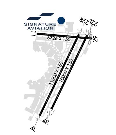
Runway Identification: 04L/22RLength: 11000 ft
Width: 150 ft
Surface: CONCRETE ASPHALT
Edge lights: High IntensityTreatment: GROOVED
Weight: PCN 96 /R/B/X/T
| | Runway: 04L | | Runway: 22R |
| Mag heading: | 39° | Mag heading: | 219° |
| Rwy Slope: | -.01% Down | Rwy Slope: | .01% Up |
| Approach: | ILS/DME | Approach: | ILS/DME |
| Pattern: | Left Traffic | Pattern: | Left Traffic |
| Markings: | PRECISION INSTRUMENT | Markings: | PRECISION INSTRUMENT |
| Marking Condition: | GOOD | Marking Condition: | GOOD |
| Arresting Dev: | | Arresting Dev: | |
| Lat & Long: | N4040.5 W07410.8 | Lat. & Long.: | N4042.2 W07409.7 |
| Elev: | 10.1 ft. MSL | Elev: | 8.9 ft. MSL |
| TCH: | 77 ft. AGL | TCH: | 70 ft. AGL |
| Visual Glide Path: | 3.10 degrees | Visual Glide Path: | 3.10 degrees |
| Displaced Threshold: | 2540 feet | Displaced Threshold: | 1440 feet |
| Touchdown Zone: | YES | Touchdown Zone: | YES |
| Touchdown Elev.: | 10.4 feet | Touchdown Elev.: | 10.4 feet |
| Visual Glide Slope: | 4-Light PAPI on LEFT side of Runway | Visual Glide Slope: | 4-Light PAPI on LEFT side of Runway |
| RVR Equipment: | TOUCHDOWN-MIDFIELD-ROLLOUT | RVR Equipment: | TOUCHDOWN-MIDFIELD-ROLLOUT |
| RVV Equipment: | NO | RVV Equipment: | NO |
| Approach Lights: | MALSR - 1,400 foot medium intensity approach lighting system with runway alignment indicator lights | Approach Lights: | MALSR - 1,400 foot medium intensity approach lighting system with runway alignment indicator lights |
| REIL: | NO | REIL: | YES |
| Centerline Lights: | YES | Centerline Lights: | YES |
| Touchdown lights: | YES | Touchdown lights: | YES |
| Runway Category: | Precision Instrument Runway | Runway Category: | Precision Instrument Runway |
| Declared Distances: | TORA:11000' TODA:11000' ASDA:11000' LDA:8460' | Declared Distances: | TORA:11000' TODA:11000' ASDA:11000' LDA:9560' |
| Obstructions: | TREE | Obstructions: | POLE |
| Marked: | NOT Marked/Lighted | Marked: | NOT Marked/Lighted |
| Clearance slope: | 26:1; APCH RATIO 50:1 TO DTHR. | Clearance slope: | 3:1; APCH RATIO 50:1 TO DTHR. |
| Obstruction height: | 65 feet AGL | Obstruction height: | 28 feet AGL |
| Dist. from runway: | 1926 feet | Dist. from runway: | 295 feet |
| Centerline offset: | 572 left of centerline | Centerline offset: | 477 feet right of centerline |
| Comments: | | Comments: | |
Runway Identification: 04R/22LLength: 10000 ft
Width: 150 ft
Surface: ASPHALT
Edge lights: High IntensityTreatment: GROOVED
Weight: PCN 96 /R/B/W/T
| | Runway: 04R | | Runway: 22L |
| Mag heading: | 39° | Mag heading: | 219° |
| Rwy Slope: | -.02% Down | Rwy Slope: | .02% Up |
| Approach: | ILS/DME | Approach: | ILS/DME |
| Pattern: | Left Traffic | Pattern: | Left Traffic |
| Markings: | PRECISION INSTRUMENT | Markings: | PRECISION INSTRUMENT |
| Marking Condition: | GOOD | Marking Condition: | GOOD |
| Arresting Dev: | | Arresting Dev: | |
| Lat & Long: | N4040.7 W07410.5 | Lat. & Long.: | N4042.1 W07409.5 |
| Elev: | 11.1 ft. MSL | Elev: | 9.4 ft. MSL |
| TCH: | 71 ft. AGL | TCH: | 60 ft. AGL |
| Visual Glide Path: | 2.95 degrees | Visual Glide Path: | 3.00 degrees |
| Displaced Threshold: | 1190 feet | Displaced Threshold: | 1793 feet |
| Touchdown Zone: | YES | Touchdown Zone: | YES |
| Touchdown Elev.: | 11.3 feet | Touchdown Elev.: | 10.7 feet |
| Visual Glide Slope: | 4-Light PAPI on LEFT side of Runway | Visual Glide Slope: | 4-Light PAPI on LEFT side of Runway |
| RVR Equipment: | TOUCHDOWN-MIDFIELD-ROLLOUT | RVR Equipment: | TOUCHDOWN-MIDFIELD-ROLLOUT |
| RVV Equipment: | NO | RVV Equipment: | NO |
| Approach Lights: | ALSF2 - standard 2,400 foot high intensity approach lighting system with sequenced flashers, Category II or III | Approach Lights: | ALSF2 - standard 2,400 foot high intensity approach lighting system with sequenced flashers, Category II or III |
| REIL: | NO | REIL: | NO |
| Centerline Lights: | YES | Centerline Lights: | YES |
| Touchdown lights: | YES | Touchdown lights: | YES |
| Runway Category: | Precision Instrument Runway | Runway Category: | Precision Instrument Runway |
| Declared Distances: | TORA:10000' TODA:10000' ASDA:10000' LDA:8810' | Declared Distances: | TORA:10000' TODA:10000' ASDA:10000' LDA:8207' |
| Obstructions: | POLE | Obstructions: | ANT |
| Marked: | LIGHTED | Marked: | NOT Marked/Lighted |
| Clearance slope: | 26:1; APCH RATIO 50:1 TO DTHR. | Clearance slope: | 11:1; APCH RATIO 50:1 TO DTHR. |
| Obstruction height: | 28 feet AGL | Obstruction height: | 30 feet AGL |
| Dist. from runway: | 953 feet | Dist. from runway: | 540 feet |
| Centerline offset: | 600 right of centerline | Centerline offset: | 534 feet right of centerline |
| Comments: | +5 FT POLE 25 FT FROM RWY END 175 FT RIGHT. | Comments: | |
Runway Identification: 11/29Length: 6726 ft
Width: 150 ft
Surface: ASPHALT
Edge lights: High IntensityTreatment: GROOVED
Weight: PCN 96 /R/B/W/T
| | Runway: 11 | | Runway: 29 |
| Mag heading: | 108° | Mag heading: | 288° |
| Rwy Slope: | -.11% Down | Rwy Slope: | .11% Up |
| Approach: | ILS/DME | Approach: | |
| Pattern: | Left Traffic | Pattern: | Left Traffic |
| Markings: | PRECISION INSTRUMENT | Markings: | NONPRECISION INSTRUMENT |
| Marking Condition: | GOOD | Marking Condition: | GOOD |
| Arresting Dev: | EMAS; ENGINEERED MATERIALS ARRESTING SYSTEM (EMAS) 182 FT IN LENGTH BY 170 FT IN WIDTH LCTD AT THE DER. | Arresting Dev: | EMAS; ENGINEERED MATERIALS ARRESTING SYSTEM (EMAS) 437 FT IN LENGTH BY 178 FT IN WIDTH LCTD AT THE DER. |
| Lat & Long: | N4042.2 W07410.8 | Lat. & Long.: | N4042.1 W07409.4 |
| Elev: | 17.4 ft. MSL | Elev: | 9.7 ft. MSL |
| TCH: | 60 ft. AGL | TCH: | 60 ft. AGL |
| Visual Glide Path: | 3.00 degrees | Visual Glide Path: | 3.00 degrees |
| Displaced Threshold: | No | Displaced Threshold: | 224 feet |
| Touchdown Zone: | YES | Touchdown Zone: | YES |
| Touchdown Elev.: | 17.4 feet | Touchdown Elev.: | 9.8 feet |
| Visual Glide Slope: | 4-Light PAPI on RIGHT side of Runway | Visual Glide Slope: | 4-Light PAPI on RIGHT side of Runway; PAPI UNUSBL 4 DEGS LEFT OF CNTRLN. |
| RVR Equipment: | TOUCHDOWN-MIDFIELD-ROLLOUT | RVR Equipment: | |
| RVV Equipment: | NO | RVV Equipment: | NO |
| Approach Lights: | | Approach Lights: | |
| REIL: | YES | REIL: | YES |
| Centerline Lights: | YES | Centerline Lights: | YES |
| Touchdown lights: | YES | Touchdown lights: | YES |
| Runway Category: | Precision Instrument Runway | Runway Category: | Runway with a Non-precision Approach having visibility minimums greater than 3/4 mile |
| Declared Distances: | TORA:6726' TODA:6726' ASDA:6726' LDA:6726' | Declared Distances: | TORA:6726' TODA:6726' ASDA:6726' LDA:6502' |
| Obstructions: | BLDG | Obstructions: | SIGN |
| Marked: | LIGHTED | Marked: | LIGHTED |
| Clearance slope: | 37:1 | Clearance slope: | 11:1; APCH RATIO 13:1 TO DTHR. |
| Obstruction height: | 158 feet AGL | Obstruction height: | 54 feet AGL |
| Dist. from runway: | 6197 feet | Dist. from runway: | 818 feet |
| Centerline offset: | 1437 left of centerline | Centerline offset: | 514 feet right of centerline |
| Comments: | | Comments: | |
Runway Identification: H1 HELIPADLength: 54 ft
Width: 54 ft
Surface: ASPHALT
Edge lights: PERI
Treatment: NONE