
| NEW BEDFORD RGNL NEW BEDFORD MA |
| |
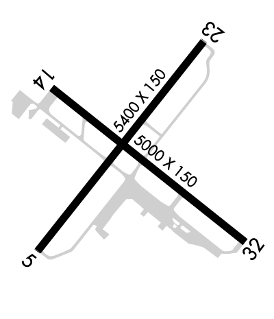
| Lat: N 4140.6 Long: W 07057.5 Elev: 79 Var: +16 Longest Runway: 5400 | ||
| Dept. ATIS: 126.85 Arr. ATIS: 126.85 AWOS: 126.85 Ground: 121.9 Tower: 118.1 | ||
| ||||||||||||||||||||||||||||||||||||||||||||
| ||||||||||||||||||||||||||||||||||||||||||||
| ||||||||||||||||||||||||||||||||||||||||||||
| ||||||||||||||||||||||||||||||||||||||||||||
| ||||||||||||||||||||||||||||||||||||||||||||
| ||||||||||||||||||||||||||||||||||||||||||||
| Rwy | Rwy | |||||||
| 5400x150 | 5400' | 109.70 - 054° | 5400x150 | 5000' | ||||
| 5000x75 | 5000' | 5000x75 | 5000' | |||||
| Runway ID | Single Wheel | Double Wheel | Double Tandem Wheel | Dual Double Wheel |
| 05/23 | 30,000 | 108,000 | 195,000 | N/A |
| 14/32 | 33,000 | 48,000 | 95,000 | N/A |
| These numbers are Advisory and are not limits. The Airport Manager should have more accurate Weight Limits | ||||
 Airport Diagram might not be current. | |
| Facility Name: | NEW BEDFORD RGNL |
| City Name: | NEW BEDFORD |
| County: | BRISTOL |
| State abbrev: | MA |
| State Name: | MASSACHUSETTS |
| Ownership: | PUBLICLY OWNED |
| Use: | OPEN TO THE PUBLIC |
| Owner's Name: | CITY OF NEW BEDFORD |
| Address: | WILLIAMS ST |
| NEW BEDFORD, MA 02740 | |
| Owner's Phone: | 508-979-1410 |
| Manager's Name: | SCOT SERVIS |
| Address: | 1569 AIRPORT ROAD |
| NEW BEDFORD, MA 02746 | |
| Phone: | (508) 991-6161 |
| FAA Region: | NEW ENGLAND |
| FAA Field Office: | NONE |
| Date | Sunrise | Sunset |
|---|---|---|
| 09/24/21 Friday | 6:33 | 18:38 |
| 09/25/21 Saturday | 6:34 | 18:36 |
| 09/26/21 Sunday | 6:35 | 18:35 |
| 09/27/21 Monday | 6:36 | 18:33 |
| 09/28/21 Tuesday | 6:37 | 18:31 |
| 09/29/21 Wednesday | 6:38 | 18:29 |
| 09/30/21 Thursday | 6:39 | 18:28 |
| 10/01/21 Friday | 6:40 | 18:26 |
| 10/02/21 Saturday | 6:41 | 18:24 |
| 10/03/21 Sunday | 6:42 | 18:23 |
| 10/04/21 Monday | 6:44 | 18:21 |
| 10/05/21 Tuesday | 6:45 | 18:19 |
| 10/06/21 Wednesday | 6:46 | 18:18 |
| 10/07/21 Thursday | 6:47 | 18:16 |
| Airport Attendance Schedule | 7 Days A Week 0600-2300 |
| Airport Status | OPERATIONAL (This Status can change at any time - please check NOTAMS) |
| Airport Lighting Schedule | WHEN ATCT CLSD ACTVT MALSR RWYS 05 & 23; REIL RWY 32; HIRL RWY 05/23; MIRL RWY 14/32 - CTAF. PAPI RWYS 14, 23 & 32 OPR 24 HRS. |
| Airport Storage Available | Tie Downs, Hanger |
| Extra Services Available | Air Freight, Charter, Flight Instruction, Aircraft Rental, Aircraft Sales |
| Wind Indicator | YES - (unlit) |
| Control Tower | YES |
| CTAF Frequency | 118.100 |
| Unicom Frequency | 122.950 |
| Rotating Beacon Color | CLEAR-GREEN (Light Land Airport) |
| Segmented Circle | NO |
| Landing Fee | NO |
| Airport Inspected | STATE - performed by FAA AIRPORTS FIELD PERSONNEL |
| Inspection Date | 06/28/2019 |
| Type of Fuel Available | Grade 100LL, JET A (freeze point -40C) |
| Airframe Repair Service | MAJOR |
| Power Plant Repair Service | MAJOR |
| Latitude | N4140.6 |
| Longitude | W07057.5 (ESTIMATED) |
| Arpt Elevation | 79ft (SURVEYED) |
| Magnetic Variation | 16W |
| 2 miles NW | of NEW BEDFORD |
| Traffic Pattern Altitude | |
| Sectional Chart | NEW YORK |
| Operations (Reported) | Yearly | Avg. Daily |
|---|---|---|
| General Aviation Transient | 24494 | 67 |
| General Aviation Local | 19196 | 53 |
| Air Taxi | 5047 | 14 |
| Commerical | 0 | 0 |
| Commuter | 0 | 0 |
| Military | 251 | 1 |
| Aircraft based on Field | |
|---|---|
| General Aviation Singles | 72 |
| General Aviation Multi | 17 |
| Jet Aircraft | 2 |
| General Aviation Helicopters | 1 |
| Military Aircraft | 0 |
| Gliders | 0 |
| Ultralights | 0 |
| FSS on field | NO |
| FSS tie-in | BRIDGEPORT |
| FSS Phone | 1-800-WX-BRIEF |
| Who issues Notams | EWB |
| Notam D service at airport | YES |
| ARTCC Name | BOSTON |
| Airport Certification | |
| Aircraft Rescue & Firefighting Index | AIRPORT HAS A CERTIFICATE UNDER CFR PART 139 |
| Airport of Entry | No |
| Custom Landing Rights | YES |
| Joint Civil/Military | No |
| Military Landing rights | YES |
| NATIONAL PLAN OF INTEGRATED AIRPORT SYSTEMS (NPIAS) |
| GRANT AGREEMENTS UNDER FAAP/ADAP/AIP |
| SURPLUS PROPERTY AGREEMENT UNDER REGULATION 16-WAA |
| ASSURANCES PURSUANT TO TITLE VI, CIVIL RIGHTS ACT OF 1964 |
| AGREEMENT UNDER DLAND OR DCLA HAS EXPIRED. |
| BIRDS & WILDLIFE ON & INVOF ARPT. |
| LDG FEES FOR ACFT OVR 5500 LBS. |
| FOR CD WHEN APCH CLSD CTC BOSTON ARTCC AT 603-879-6859. |
| ARPT CLSD TO NON SKED ACR ACFT WITH MORE THAN 31 PAX EXC 48 HR PPR 508-991-6161. |
Airport Communications & Frequencies:
| |||||||||||||||||||||||||||||
| Runway: 05 | Runway: 23 | ||
| Mag heading: | 54° | Mag heading: | 234° |
| Rwy Slope: | .27% Up | Rwy Slope: | -.27% Down |
| Approach: | ILS/DME | Approach: | |
| Pattern: | Left Traffic | Pattern: | Left Traffic |
| Markings: | PRECISION INSTRUMENT | Markings: | PRECISION INSTRUMENT |
| Marking Condition: | GOOD | Marking Condition: | GOOD |
| Arresting Dev: | Arresting Dev: | ||
| Lat & Long: | N4140.3 W07057.9 | Lat. & Long.: | N4141.0 W07057.2 |
| Elev: | 64.4 ft. MSL | Elev: | 79.1 ft. MSL |
| TCH: | TCH: | 46 ft. AGL | |
| Visual Glide Path: | Visual Glide Path: | 3.00 degrees | |
| Displaced Threshold: | No | Displaced Threshold: | 400 feet |
| Touchdown Zone: | YES | Touchdown Zone: | YES |
| Touchdown Elev.: | 70.4 feet | Touchdown Elev.: | 78.1 feet |
| Visual Glide Slope: | Visual Glide Slope: | 4-Light PAPI on LEFT side of Runway | |
| RVR Equipment: | TOUCHDOWN | RVR Equipment: | ROLLOUT |
| RVV Equipment: | NO | RVV Equipment: | NO |
| Approach Lights: | MALSR - 1,400 foot medium intensity approach lighting system with runway alignment indicator lights | Approach Lights: | MALSR - 1,400 foot medium intensity approach lighting system with runway alignment indicator lights |
| REIL: | NO | REIL: | NO |
| Centerline Lights: | NO | Centerline Lights: | NO |
| Touchdown lights: | NO | Touchdown lights: | NO |
| Runway Category: | Precision Instrument Runway | Runway Category: | Runway with a Non-precision Approach having visibility minimums greater than 3/4 mile |
| Declared Distances: | Declared Distances: | ||
| Obstructions: | TREE | Obstructions: | TREE |
| Marked: | NOT Marked/Lighted | Marked: | NOT Marked/Lighted |
| Clearance slope: | 50:1 | Clearance slope: | 34:1; APCH SLP 50:1 AT DSPLCD THR. |
| Obstruction height: | 20 feet AGL | Obstruction height: | 35 feet AGL |
| Dist. from runway: | 1200 feet | Dist. from runway: | 1400 feet |
| Centerline offset: | B | Centerline offset: | 125B |
| Comments: | Comments: |
| Runway: 14 | Runway: 32 | ||
| Mag heading: | 144° | Mag heading: | 324° |
| Rwy Slope: | -.22% Down | Rwy Slope: | .22% Up |
| Approach: | Approach: | ||
| Pattern: | Left Traffic | Pattern: | Left Traffic |
| Markings: | BASIC | Markings: | BASIC |
| Marking Condition: | GOOD | Marking Condition: | GOOD |
| Arresting Dev: | Arresting Dev: | ||
| Lat & Long: | N4140.8 W07057.8 | Lat. & Long.: | N4140.3 W07057.0 |
| Elev: | 77.5 ft. MSL | Elev: | 66.3 ft. MSL |
| TCH: | 50 ft. AGL | TCH: | 50 ft. AGL |
| Visual Glide Path: | 3.42 degrees | Visual Glide Path: | 3.50 degrees |
| Displaced Threshold: | No | Displaced Threshold: | No |
| Touchdown Zone: | YES | Touchdown Zone: | YES |
| Touchdown Elev.: | 77.5 feet | Touchdown Elev.: | 68.5 feet |
| Visual Glide Slope: | 4-Light PAPI on LEFT side of Runway | Visual Glide Slope: | 4-Light PAPI on LEFT side of Runway |
| RVR Equipment: | RVR Equipment: | ||
| RVV Equipment: | NO | RVV Equipment: | NO |
| Approach Lights: | Approach Lights: | ||
| REIL: | NO | REIL: | YES |
| Centerline Lights: | NO | Centerline Lights: | NO |
| Touchdown lights: | NO | Touchdown lights: | NO |
| Runway Category: | Runway with a Non-precision Approach having visibility minimums greater than 3/4 mile | Runway Category: | Runway with a Non-precision Approach having visibility minimums greater than 3/4 mile |
| Declared Distances: | Declared Distances: | ||
| Obstructions: | TREE | Obstructions: | TREES |
| Marked: | NOT Marked/Lighted | Marked: | NOT Marked/Lighted |
| Clearance slope: | 20:1 | Clearance slope: | 36:1 |
| Obstruction height: | 10 feet AGL | Obstruction height: | 11 feet AGL |
| Dist. from runway: | 400 feet | Dist. from runway: | 600 feet |
| Centerline offset: | Centerline offset: | 130 feet right of centerline | |
| Comments: | Comments: |
Thanks for using FltPlan.com
all rights reserved © 1999-2021 by Flight Plan LLC
