
| EVANSTON-UINTA COUNTY BURNS EVANSTON WY |
| |
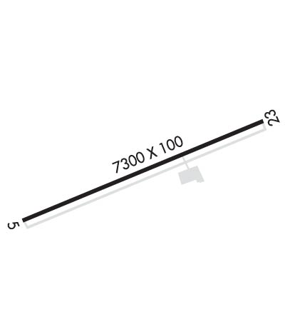
| Lat: N 4116.5 Long: W 11102.1 Elev: 7143 Var: -13 Longest Runway: 7300 | ||
| Clr Del: 121.72 GCO AWOS: 120.0 CTAF: 123.0 | ||
| ||||||||||||||||||||||||||||||||||||||||||||
| ||||||||||||||||||||||||||||||||||||||||||||
| ||||||||||||||||||||||||||||||||||||||||||||
| Rwy | Rwy | |||||||
| 7300x100 | 7300' | 7300x100 | 7300' | 108.90 - 233° | ||||
| Runway ID | Single Wheel | Double Wheel | Double Tandem Wheel | Dual Double Wheel |
| 05/23 | 73,000 | 93,000 | 148,000 | N/A |
| These numbers are Advisory and are not limits. The Airport Manager should have more accurate Weight Limits | ||||
 Airport Diagram might not be current. | |
| Facility Name: | EVANSTON-UINTA COUNTY BURNS FLD |
| City Name: | EVANSTON |
| County: | UINTA |
| State abbrev: | WY |
| State Name: | WYOMING |
| Ownership: | PUBLICLY OWNED |
| Use: | OPEN TO THE PUBLIC |
| Owner's Name: | CITY OF EVANSTON; COUNTY OF UINTA. |
| Address: | 1200 MAIN ST |
| EVANSTON, WY 82930 | |
| Owner's Phone: | (307) 783-0318 |
| Manager's Name: | MIKE LASALLE |
| Address: | PO BOX 756 |
| EVANSTON, WY 82931 | |
| Phone: | 307-789-2256 |
| FAA Region: | NORTHWEST MOUNTAIN |
| FAA Field Office: | DEN |
| Date | Sunrise | Sunset |
|---|---|---|
| 06/08/26 Monday | 5:51 | 20:55 |
| 06/09/26 Tuesday | 5:51 | 20:56 |
| 06/10/26 Wednesday | 5:51 | 20:57 |
| 06/11/26 Thursday | 5:51 | 20:57 |
| 06/12/26 Friday | 5:50 | 20:58 |
| 06/13/26 Saturday | 5:50 | 20:58 |
| 06/14/26 Sunday | 5:50 | 20:58 |
| 06/15/26 Monday | 5:50 | 20:59 |
| 06/16/26 Tuesday | 5:50 | 20:59 |
| 06/17/26 Wednesday | 5:50 | 21:00 |
| 06/18/26 Thursday | 5:51 | 21:00 |
| 06/19/26 Friday | 5:51 | 21:00 |
| 06/20/26 Saturday | 5:51 | 21:00 |
| 06/21/26 Sunday | 5:51 | 21:01 |
| Airport Attendance Schedule | 7 Days A Week 0700-1900; FOR SVC AFT HRS CALL 1-307-789-2256. |
| Airport Status | OPERATIONAL (This Status can change at any time - please check NOTAMS) |
| Airport Lighting Schedule | ACTVT MALSR RWY 23; REIL RWY 05; HIRL RWY 05/23 - CTAF. RWY 05/23 PAPIS ON CONSLY. |
| Airport Storage Available | Tie Downs, Hanger |
| Extra Services Available | NONE |
| Wind Indicator | YES - (lighted) |
| Control Tower | NO |
| CTAF Frequency | 123.000 |
| Unicom Frequency | 123.000 |
| Rotating Beacon Color | WG |
| Segmented Circle | YES |
| Landing Fee | NO |
| Airport Inspected | STATE - performed by STATE AERONAUTICAL PERSONNEL |
| Inspection Date | 05/22/2025 |
| Type of Fuel Available | Grade 100LL, JET A (freeze point -40C) |
| Airframe Repair Service | MAJOR |
| Power Plant Repair Service | MAJOR |
| Latitude | N4116.5 |
| Longitude | W11102.1 (ESTIMATED) |
| Arpt Elevation | 7142ft (SURVEYED) |
| Magnetic Variation | 13E |
| 3 miles W | of EVANSTON |
| Traffic Pattern Altitude | |
| Sectional Chart | SALT LAKE CITY |
| Operations (Reported) | Yearly | Avg. Daily |
|---|---|---|
| General Aviation Transient | 0 | 0 |
| General Aviation Local | 0 | 0 |
| Air Taxi | 0 | 0 |
| Commerical | 0 | 0 |
| Commuter | 0 | 0 |
| Military | 0 | 0 |
| Aircraft based on Field | |
|---|---|
| General Aviation Singles | 0 |
| General Aviation Multi | 0 |
| Jet Aircraft | 0 |
| General Aviation Helicopters | 0 |
| Military Aircraft | 0 |
| Gliders | 0 |
| Ultralights | 0 |
| FSS on field | NO |
| FSS tie-in | CASPER |
| FSS Phone | 1-800-WX-BRIEF |
| Who issues Notams | EVW |
| Notam D service at airport | YES |
| ARTCC Name | SALT LAKE CITY |
| Airport Certification | |
| Aircraft Rescue & Firefighting Index | None |
| Airport of Entry | No |
| Custom Landing Rights | No |
| Joint Civil/Military | No |
| Military Landing rights | No |
| NATIONAL PLAN OF INTEGRATED AIRPORT SYSTEMS (NPIAS) |
| GRANT AGREEMENTS UNDER FAAP/ADAP/AIP |
| ASSURANCES PURSUANT TO TITLE VI, CIVIL RIGHTS ACT OF 1964 |
| GCO AVBL ON FREQ 121.72 THRU SALT LAKE ARTCC CD, CASPER FSS NOT AVBL. |
| FOR CD IF UNA VIA GCO CTC SALT LAKE ARTCC AT 801-320-2568. |
| RWY 05/2 3 PCR VALUE: 295/F/D/X/T |
Airport Communications & Frequencies:
| |||||||||
| Runway: 05 | Runway: 23 | ||
| Mag heading: | 53° | Mag heading: | 233° |
| Rwy Slope: | .02% Up | Rwy Slope: | -.02% Down |
| Approach: | Approach: | ILS/DME | |
| Pattern: | Left Traffic | Pattern: | Left Traffic |
| Markings: | PRECISION INSTRUMENT | Markings: | PRECISION INSTRUMENT |
| Marking Condition: | GOOD | Marking Condition: | GOOD |
| Arresting Dev: | Arresting Dev: | ||
| Lat & Long: | N4116.3 W11102.8 | Lat. & Long.: | N4116.7 W11101.3 |
| Elev: | 7135.1 ft. MSL | Elev: | 7136.4 ft. MSL |
| TCH: | 45 ft. AGL | TCH: | 44 ft. AGL |
| Visual Glide Path: | 3.00 degrees | Visual Glide Path: | 3.00 degrees |
| Displaced Threshold: | No | Displaced Threshold: | No |
| Touchdown Zone: | YES | Touchdown Zone: | YES |
| Touchdown Elev.: | 7141.0 feet | Touchdown Elev.: | 7142.7 feet |
| Visual Glide Slope: | 4-Light PAPI on LEFT side of Runway | Visual Glide Slope: | 4-Light PAPI on LEFT side of Runway |
| RVR Equipment: | RVR Equipment: | ||
| RVV Equipment: | NO | RVV Equipment: | NO |
| Approach Lights: | Approach Lights: | MALSR - 1,400 foot medium intensity approach lighting system with runway alignment indicator lights | |
| REIL: | YES | REIL: | NO |
| Centerline Lights: | NO | Centerline Lights: | NO |
| Touchdown lights: | NO | Touchdown lights: | NO |
| Runway Category: | Runway with a Non-precision Approach having visibility minimums greater than 3/4 mile | Runway Category: | Precision Instrument Runway |
| Declared Distances: | Declared Distances: |
Thanks for using FltPlan.com
all rights reserved © 1999-2026 by Flight Plan LLC
