
| EVELETH-VIRGINIA MUNI EVELETH MN |
| |
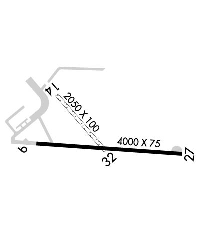
| Lat: N 4725.5 Long: W 09229.8 Elev: 1376 Var: -00 Longest Runway: 4000 | ||
| AWOS: 108.2 CTAF: 122.7 | ||
| ||||||||||||||||||||||||||||||||||||||||||||
| ||||||||||||||||||||||||||||||||||||||||||||
| ||||||||||||||||||||||||||||||||||||||||||||
| Rwy | Rwy | |||||||
| 4000x75 | 4000' | 4000x75 | 4000' | |||||
| 2050x100 | 2050' | 2050x100 | 2050' | |||||
| Runway ID | Single Wheel | Double Wheel | Double Tandem Wheel | Dual Double Wheel |
| 09/27 | 12,000 | N/A | N/A | N/A |
| 14/32 | 10,000 | N/A | N/A | N/A |
| These numbers are Advisory and are not limits. The Airport Manager should have more accurate Weight Limits | ||||
 Airport Diagram might not be current. | |
| Facility Name: | EVELETH-VIRGINIA MUNI |
| City Name: | EVELETH |
| County: | ST LOUIS |
| State abbrev: | MN |
| State Name: | MINNESOTA |
| Ownership: | PUBLICLY OWNED |
| Use: | OPEN TO THE PUBLIC |
| Owner's Name: | EVELETH & VIRGINIA CITIES; CITY OF VIRGINIA, CITY CLERK, 327 FIRST ST. S, VA, MN 55792, PHONE 218-748-7500. |
| Address: | 413 PIERCE ST., BOX 401 |
| EVELETH, MN 55734 | |
| Owner's Phone: | 218-744-2501 |
| Manager's Name: | GARY ULMAN |
| Address: | 4280 MILLER TRUNK RD.; EMAIL ADDRESS: TACONITEAVIATION@GMAIL.COM |
| EVELETH, MN 55734 | |
| Phone: | 218-744-1428 |
| FAA Region: | GREAT LAKES |
| FAA Field Office: | DMA |
| Date | Sunrise | Sunset |
|---|---|---|
| 09/24/21 Friday | 6:59 | 19:04 |
| 09/25/21 Saturday | 7:00 | 19:02 |
| 09/26/21 Sunday | 7:02 | 19:00 |
| 09/27/21 Monday | 7:03 | 18:58 |
| 09/28/21 Tuesday | 7:05 | 18:56 |
| 09/29/21 Wednesday | 7:06 | 18:54 |
| 09/30/21 Thursday | 7:07 | 18:52 |
| 10/01/21 Friday | 7:09 | 18:50 |
| 10/02/21 Saturday | 7:10 | 18:48 |
| 10/03/21 Sunday | 7:11 | 18:46 |
| 10/04/21 Monday | 7:13 | 18:44 |
| 10/05/21 Tuesday | 7:14 | 18:42 |
| 10/06/21 Wednesday | 7:16 | 18:40 |
| 10/07/21 Thursday | 7:17 | 18:38 |
| Airport Attendance Schedule | MON-FRI 0800-1900, SAT 0800-1800, SUN 0900-1700 |
| Airport Status | OPERATIONAL (This Status can change at any time - please check NOTAMS) |
| Airport Lighting Schedule | ACTVT REIL RWY 27; PAPI RWY 09 & 27; MIRL 09/27 & 14/32 - CTAF. MIRL RWY 09/27 & 14/32 PRESET ON LOW INTST; INCR INTST - CTAF. |
| Airport Storage Available | Tie Downs, Hanger |
| Extra Services Available | Charter, Flight Instruction, Aircraft Rental, Annual Surveying |
| Wind Indicator | YES - (lighted) |
| Control Tower | NO |
| CTAF Frequency | 122.700 |
| Unicom Frequency | 122.700 |
| Rotating Beacon Color | CLEAR-GREEN (Light Land Airport) |
| Segmented Circle | NO |
| Landing Fee | NO |
| Airport Inspected | STATE - performed by STATE AERONAUTICAL PERSONNEL |
| Inspection Date | 09/17/2020 |
| Type of Fuel Available | Grade 100LL, JET A (freeze point -40C); -10AFT HR FUEL CALL 218-258-3639. |
| Airframe Repair Service | MINOR |
| Power Plant Repair Service | MINOR |
| Latitude | N4725.5 |
| Longitude | W09229.8 (ESTIMATED) |
| Arpt Elevation | 1376ft (SURVEYED) |
| Magnetic Variation | 00E |
| 3 miles SE | of EVELETH |
| Traffic Pattern Altitude | |
| Sectional Chart | GREEN BAY |
| Operations (Reported) | Yearly | Avg. Daily |
|---|---|---|
| General Aviation Transient | 11000 | 30 |
| General Aviation Local | 5100 | 14 |
| Air Taxi | 1600 | 4 |
| Commerical | 0 | 0 |
| Commuter | 0 | 0 |
| Military | 0 | 0 |
| Aircraft based on Field | |
|---|---|
| General Aviation Singles | 36 |
| General Aviation Multi | 1 |
| Jet Aircraft | 0 |
| General Aviation Helicopters | 0 |
| Military Aircraft | 0 |
| Gliders | 0 |
| Ultralights | 0 |
| FSS on field | NO |
| FSS tie-in | PRINCETON |
| FSS Phone | 1-800-WX-BRIEF |
| Who issues Notams | EVM |
| Notam D service at airport | YES |
| ARTCC Name | MINNEAPOLIS |
| Airport Certification | |
| Aircraft Rescue & Firefighting Index | None |
| Airport of Entry | No |
| Custom Landing Rights | No |
| Joint Civil/Military | No |
| Military Landing rights | YES |
| NATIONAL PLAN OF INTEGRATED AIRPORT SYSTEMS (NPIAS) |
| GRANT AGREEMENTS UNDER FAAP/ADAP/AIP |
| ASSURANCES PURSUANT TO TITLE VI, CIVIL RIGHTS ACT OF 1964 |
| AGREEMENT UNDER DLAND OR DCLA HAS EXPIRED. |
| DEER AND BIRDS ON & INVOF ARPT. |
| PYVMT HEAVING ON RAMP NEAR HANGAR. |
| FOR CD CTC DULUTH APCH AT 218-740-5950. |
| RWY 14/3 2 NOT PLWD WINT MONTHS; USBL WITH SKIS. |
Airport Communications & Frequencies:
| ||||||||||||||
| Runway: 09 | Runway: 27 | ||
| Mag heading: | 94° | Mag heading: | 274° |
| Rwy Slope: | -.11% Down | Rwy Slope: | .11% Up |
| Approach: | Approach: | ||
| Pattern: | Left Traffic | Pattern: | Left Traffic |
| Markings: | NONPRECISION INSTRUMENT | Markings: | NONPRECISION INSTRUMENT |
| Marking Condition: | GOOD | Marking Condition: | GOOD |
| Arresting Dev: | Arresting Dev: | ||
| Lat & Long: | N4725.4 W09230.2 | Lat. & Long.: | N4725.4 W09229.2 |
| Elev: | 1374.3 ft. MSL | Elev: | 1370.0 ft. MSL |
| TCH: | 40 ft. AGL | TCH: | 40 ft. AGL |
| Visual Glide Path: | 3.00 degrees | Visual Glide Path: | 3.00 degrees |
| Displaced Threshold: | No | Displaced Threshold: | No |
| Touchdown Zone: | YES | Touchdown Zone: | YES |
| Touchdown Elev.: | 1374.3 feet | Touchdown Elev.: | 1371.7 feet |
| Visual Glide Slope: | 4-Light PAPI on LEFT side of Runway | Visual Glide Slope: | 4-Light PAPI on LEFT side of Runway |
| RVR Equipment: | RVR Equipment: | ||
| RVV Equipment: | NO | RVV Equipment: | NO |
| Approach Lights: | Approach Lights: | ||
| REIL: | NO | REIL: | YES |
| Centerline Lights: | NO | Centerline Lights: | NO |
| Touchdown lights: | NO | Touchdown lights: | NO |
| Runway Category: | Runway with a Visual Approach | Runway Category: | Runway with a Non-precision Approach |
| Declared Distances: | Declared Distances: | ||
| Obstructions: | TREES | Obstructions: | |
| Marked: | NOT Marked/Lighted | Marked: | |
| Clearance slope: | 18:1 | Clearance slope: | 20:1 |
| Obstruction height: | 68 feet AGL | Obstruction height: | |
| Dist. from runway: | 1463 feet | Dist. from runway: | |
| Centerline offset: | 61 right of centerline | Centerline offset: | |
| Comments: | Comments: |
| Runway: 14 | Runway: 32 | ||
| Mag heading: | 139° | Mag heading: | 319° |
| Rwy Slope: | -.28% Down | Rwy Slope: | .28% Up |
| Approach: | Approach: | ||
| Pattern: | Left Traffic | Pattern: | Left Traffic |
| Markings: | BASIC | Markings: | BASIC |
| Marking Condition: | GOOD | Marking Condition: | GOOD |
| Arresting Dev: | Arresting Dev: | ||
| Lat & Long: | N4725.7 W09230.1 | Lat. & Long.: | N4725.4 W09229.8 |
| Elev: | 1376.0 ft. MSL | Elev: | 1370.3 ft. MSL |
| TCH: | TCH: | ||
| Visual Glide Path: | Visual Glide Path: | ||
| Displaced Threshold: | No | Displaced Threshold: | No |
| Touchdown Zone: | YES | Touchdown Zone: | YES |
| Touchdown Elev.: | 1376.0 feet | Touchdown Elev.: | 1376.0 feet |
| Visual Glide Slope: | Visual Glide Slope: | ||
| RVR Equipment: | RVR Equipment: | ||
| RVV Equipment: | NO | RVV Equipment: | NO |
| Approach Lights: | Approach Lights: | ||
| REIL: | NO | REIL: | NO |
| Centerline Lights: | NO | Centerline Lights: | NO |
| Touchdown lights: | NO | Touchdown lights: | NO |
| Runway Category: | Runway with a Visual Approach | Runway Category: | Runway with a Visual Approach |
| Declared Distances: | Declared Distances: | ||
| Obstructions: | TREES | Obstructions: | |
| Marked: | NOT Marked/Lighted | Marked: | |
| Clearance slope: | 19:1 | Clearance slope: | 20:1 |
| Obstruction height: | 72 feet AGL | Obstruction height: | |
| Dist. from runway: | 1427 feet | Dist. from runway: | |
| Centerline offset: | 257 right of centerline | Centerline offset: | |
| Comments: | Comments: |
Thanks for using FltPlan.com
all rights reserved © 1999-2021 by Flight Plan LLC
