
| MAHLON SWEET FIELD EUGENE OR |
| |
| Lat: N 4407.5 Long: W 12312.7 Elev: 374 Var: -15 Longest Runway: 8009 | ||
| Clr Del: 121.7 Dept. ATIS: 125.22 Arr. ATIS: 125.22 AWOS: 125.2 Ground: 121.7 Tower: 118.9 | ||
| |||||||||||||||||||||||||||||||||||||||||||||||||||||||||||||
| |||||||||||||||||||||||||||||||||||||||||||||||||||||||||||||
| |||||||||||||||||||||||||||||||||||||||||||||||||||||||||||||
| |||||||||||||||||||||||||||||||||||||||||||||||||||||||||||||
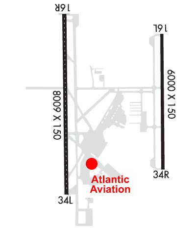
| Rwy | Rwy | |||||||
| 6000x150 | 6000' | 111.75 - 164° | 6000x150 | 6000' | ||||
| 8009x150 | 8009' | 110.10 - 164° | 8009x150 | 8009' | ||||
| Runway ID | Single Wheel | Double Wheel | Double Tandem Wheel | Dual Double Wheel |
| 16L/34R | 120,000 | 211,000 | 342,000 | N/A |
| 16R/34L | 120,000 | 250,000 | 550,000 | N/A |
| These numbers are Advisory and are not limits. The Airport Manager should have more accurate Weight Limits | ||||
 Airport Diagram might not be current. | |
| Facility Name: | MAHLON SWEET FLD |
| City Name: | EUGENE |
| County: | LANE |
| State abbrev: | OR |
| State Name: | OREGON |
| Ownership: | PUBLICLY OWNED |
| Use: | OPEN TO THE PUBLIC |
| Owner's Name: | CITY OF EUGENE |
| Address: | 500 E. 4TH |
| EUGENE, OR 97401 | |
| Owner's Phone: | (541) 682-5010 |
| Manager's Name: | CATHRYN STEPHENS |
| Address: | 28855 LOCKHEED DRIVE |
| EUGENE, OR 97402 | |
| Phone: | 541-682-5430 |
| FAA Region: | NORTHWEST MOUNTAIN |
| FAA Field Office: | SEA |
| Date | Sunrise | Sunset |
|---|---|---|
| 06/08/26 Monday | 5:30 | 20:54 |
| 06/09/26 Tuesday | 5:30 | 20:55 |
| 06/10/26 Wednesday | 5:29 | 20:55 |
| 06/11/26 Thursday | 5:29 | 20:56 |
| 06/12/26 Friday | 5:29 | 20:56 |
| 06/13/26 Saturday | 5:29 | 20:57 |
| 06/14/26 Sunday | 5:29 | 20:57 |
| 06/15/26 Monday | 5:29 | 20:58 |
| 06/16/26 Tuesday | 5:29 | 20:58 |
| 06/17/26 Wednesday | 5:29 | 20:59 |
| 06/18/26 Thursday | 5:29 | 20:59 |
| 06/19/26 Friday | 5:29 | 20:59 |
| 06/20/26 Saturday | 5:29 | 21:00 |
| 06/21/26 Sunday | 5:29 | 21:00 |
| Airport Attendance Schedule | CONTINUOUS |
| Airport Status | OPERATIONAL (This Status can change at any time - please check NOTAMS) |
| Airport Lighting Schedule | WHEN ATCT CLSD ACTVT ALSF2 RWY 16R; MALSR RWY 16L; ODALS RWY 34L; REIL RWY 34R - CTAF. PAPI RWY 16R, 16L & 34R; VASI RWY 34L OPR CONSLY. WHEN ATCT CLSD HIRL RWY 16L/34R & 16R/34L PRESET MED INTST. |
| Airport Storage Available | Tie Downs |
| Extra Services Available | Air Freight, Crop Dusting, Air Ambulance, Avionics, Cargo Handling, Charter, Flight Instruction, Aircraft Rental, Aircraft Sales |
| Wind Indicator | YES - (lighted) |
| Control Tower | YES |
| CTAF Frequency | 118.900 |
| Unicom Frequency | 122.950 |
| Rotating Beacon Color | WG |
| Segmented Circle | YES |
| Landing Fee | YES |
| Airport Inspected | FEDERAL - performed by FAA AIRPORTS FIELD PERSONNEL |
| Inspection Date | 07/17/2024 |
| Type of Fuel Available | Grade 100LL, JET A (freeze point -40C) |
| Airframe Repair Service | MAJOR |
| Power Plant Repair Service | MAJOR |
| Latitude | N4407.5 |
| Longitude | W12312.7 (ESTIMATED) |
| Arpt Elevation | 373ft (SURVEYED) |
| Magnetic Variation | 15E |
| 7 miles NW | of EUGENE |
| Traffic Pattern Altitude | 800 |
| Sectional Chart | KLAMATH FALLS |
| Operations (Reported) | Yearly | Avg. Daily |
|---|---|---|
| General Aviation Transient | 0 | 0 |
| General Aviation Local | 0 | 0 |
| Air Taxi | 0 | 0 |
| Commerical | 0 | 0 |
| Commuter | 0 | 0 |
| Military | 0 | 0 |
| Aircraft based on Field | |
|---|---|
| General Aviation Singles | 0 |
| General Aviation Multi | 0 |
| Jet Aircraft | 0 |
| General Aviation Helicopters | 0 |
| Military Aircraft | 0 |
| Gliders | 0 |
| Ultralights | 0 |
| FSS on field | NO |
| FSS tie-in | MC MINNVILLE |
| FSS Phone | 1-800-WX-BRIEF |
| Who issues Notams | EUG |
| Notam D service at airport | YES |
| ARTCC Name | SEATTLE |
| Airport Certification | AIRPORT RECEIVING SCHEDULED AIR CARRIER SERVICE FROM CARRIERS CERTIFICATED BY THE CIVIL AERONAUTICS BOARD; PPR FOR UNSKED ACR OPS GTR THAN 30 PAX SEATS - 541-682-5430. ARFF AVBL H24. ARFF INDEX D H24; PPR. |
| Aircraft Rescue & Firefighting Index | AIRPORT HAS A CERTIFICATE UNDER CFR PART 139 |
| Airport of Entry | No |
| Custom Landing Rights | No |
| Joint Civil/Military | No |
| Military Landing rights | YES |
| NATIONAL PLAN OF INTEGRATED AIRPORT SYSTEMS (NPIAS) |
| GRANT AGREEMENTS UNDER FAAP/ADAP/AIP |
| ASSURANCES PURSUANT TO TITLE VI, CIVIL RIGHTS ACT OF 1964 |
| AGREEMENT UNDER DLAND OR DCLA HAS EXPIRED. |
| WATERFOWL & BIRDS ON & INVOF ARPT. |
| TWYS H & K UNAVBL TO 21000 LB SW & 40000 LB DW GWT. |
| TRML APRON CLSD; PPR EXC SKED ACR. |
| HEL ARR & DEP AVOID OTFC OF AIRLINE PAX TRML & RAMP E OF RWY 16R/34L. |
| RWY 34L ACES BYD TWY A6 NA. |
| FOR CD IF UNA TO CTC ON FSS FREQ, CTC SEATTLE ARTCC AT 253-351-3694. |
| RWY 16L/ 34RPCR VALUE: 688/F/D/X/T |
| RWY 16R/ 34LPCR VALUE: 2818/F/D/X/T |
Airport Communications & Frequencies:
| |||||||||||||||||||||||||||||||||||||||||||||
| Runway: 16L | Runway: 34R | ||
| Mag heading: | 164° | Mag heading: | 344° |
| Rwy Slope: | .17% Up | Rwy Slope: | -.17% Down |
| Approach: | ILS/DME | Approach: | |
| Pattern: | Left Traffic | Pattern: | Left Traffic |
| Markings: | PRECISION INSTRUMENT | Markings: | PRECISION INSTRUMENT |
| Marking Condition: | GOOD | Marking Condition: | GOOD |
| Arresting Dev: | Arresting Dev: | ||
| Lat & Long: | N4408.0 W12312.2 | Lat. & Long.: | N4407.0 W12312.1 |
| Elev: | 363.5 ft. MSL | Elev: | 373.6 ft. MSL |
| TCH: | 52 ft. AGL | TCH: | 50 ft. AGL |
| Visual Glide Path: | 3.00 degrees | Visual Glide Path: | 3.00 degrees |
| Displaced Threshold: | No | Displaced Threshold: | No |
| Touchdown Zone: | YES | Touchdown Zone: | YES |
| Touchdown Elev.: | 368.6 feet | Touchdown Elev.: | 373.7 feet |
| Visual Glide Slope: | 4-Light PAPI on LEFT side of Runway | Visual Glide Slope: | 4-Light PAPI on LEFT side of Runway |
| RVR Equipment: | RVR Equipment: | ||
| RVV Equipment: | NO | RVV Equipment: | NO |
| Approach Lights: | MALSR - 1,400 foot medium intensity approach lighting system with runway alignment indicator lights | Approach Lights: | |
| REIL: | NO | REIL: | YES |
| Centerline Lights: | NO | Centerline Lights: | NO |
| Touchdown lights: | NO | Touchdown lights: | NO |
| Runway Category: | Precision Instrument Runway | Runway Category: | Runway with a Non-precision Approach having visibility minimums greater than 3/4 mile |
| Declared Distances: | TORA:6000' TODA:6000' ASDA:6000' LDA:6000' | Declared Distances: | TORA:6000' TODA:6000' ASDA:6000' LDA:6000' |
| Runway: 16R | Runway: 34L | ||
| Mag heading: | 164° | Mag heading: | 344° |
| Rwy Slope: | .07% Up | Rwy Slope: | -.07% Down |
| Approach: | ILS/DME | Approach: | |
| Pattern: | Left Traffic | Pattern: | Left Traffic |
| Markings: | PRECISION INSTRUMENT | Markings: | PRECISION INSTRUMENT |
| Marking Condition: | GOOD | Marking Condition: | GOOD |
| Arresting Dev: | Arresting Dev: | ||
| Lat & Long: | N4408.1 W12313.1 | Lat. & Long.: | N4406.8 W12313.1 |
| Elev: | 360.2 ft. MSL | Elev: | 365.5 ft. MSL |
| TCH: | 50 ft. AGL | TCH: | 53 ft. AGL |
| Visual Glide Path: | 3.00 degrees | Visual Glide Path: | 3.00 degrees |
| Displaced Threshold: | No | Displaced Threshold: | No |
| Touchdown Zone: | YES | Touchdown Zone: | YES |
| Touchdown Elev.: | 363.6 feet | Touchdown Elev.: | 368.1 feet |
| Visual Glide Slope: | 4-Light PAPI on LEFT side of Runway | Visual Glide Slope: | 4-BOX VASI ON LEFT SIDE OF RUNWAY |
| RVR Equipment: | TOUCHDOWN-MIDFIELD-ROLLOUT | RVR Equipment: | TOUCHDOWN-MIDFIELD-ROLLOUT |
| RVV Equipment: | NO | RVV Equipment: | NO |
| Approach Lights: | ALSF2 - standard 2,400 foot high intensity approach lighting system with sequenced flashers, Category II or III | Approach Lights: | ODALS - omnidirectional approach lighting system |
| REIL: | NO | REIL: | NO |
| Centerline Lights: | YES | Centerline Lights: | YES |
| Touchdown lights: | YES | Touchdown lights: | NO |
| Runway Category: | Precision Instrument Runway | Runway Category: | Runway with a Non-precision Approach having visibility minimums greater than 3/4 mile |
| Declared Distances: | TORA:8009' TODA:8009' ASDA:8009' LDA:8009' | Declared Distances: | TORA:8009' TODA:8009' ASDA:8009' LDA:8009' |
Thanks for using FltPlan.com
all rights reserved © 1999-2026 by Flight Plan LLC

