| WEST BEND MUNI WEST BEND WI |
| |
| Lat: N 4325.3 Long: W 08807.7 Elev: 888 Var: +01 Longest Runway: 4494 | ||
| Clr Del: 124.75 AWOS: 120.0 CTAF: 123.05 | ||
| |||||||||||||||||||||||||||||||||||||||||||||||||||||||||||||
| |||||||||||||||||||||||||||||||||||||||||||||||||||||||||||||
| |||||||||||||||||||||||||||||||||||||||||||||||||||||||||||||
| Rwy | Rwy | |||||||
| 3898x75 | 3898' | 3898x75 | 3898' | |||||
| 4494x75 | 4494' | 4494x75 | 4494' | 108.90 - 309° | ||||
| Runway ID | Single Wheel | Double Wheel | Double Tandem Wheel | Dual Double Wheel |
| 06/24 | 12,000 | N/A | N/A | N/A |
| 13/31 | 15,000 | N/A | N/A | N/A |
| H1 | N/A | N/A | N/A | N/A |
| These numbers are Advisory and are not limits. The Airport Manager should have more accurate Weight Limits | ||||
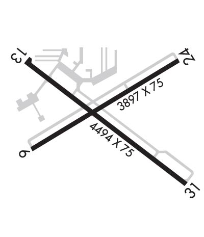 Airport Diagram might not be current. | |
| Facility Name: | WEST BEND MUNI |
| City Name: | WEST BEND |
| County: | WASHINGTON |
| State abbrev: | WI |
| State Name: | WISCONSIN |
| Ownership: | PUBLICLY OWNED |
| Use: | OPEN TO THE PUBLIC |
| Owner's Name: | CITY OF WEST BEND |
| Address: | 1115 S MAIN STREET |
| WEST BEND, WI 53095 | |
| Owner's Phone: | 262-483-7432 |
| Manager's Name: | MIKE SHAW |
| Address: | 1115 SOUTH MAIN; SHAWM@WESTBENDWI.GOV. |
| WEST BEND, WI 53095 | |
| Phone: | 262-483-7432 |
| FAA Region: | GREAT LAKES |
| FAA Field Office: | CHI |
| Date | Sunrise | Sunset |
|---|---|---|
| 06/08/26 Monday | 5:12 | 20:31 |
| 06/09/26 Tuesday | 5:12 | 20:32 |
| 06/10/26 Wednesday | 5:12 | 20:32 |
| 06/11/26 Thursday | 5:11 | 20:33 |
| 06/12/26 Friday | 5:11 | 20:33 |
| 06/13/26 Saturday | 5:11 | 20:34 |
| 06/14/26 Sunday | 5:11 | 20:34 |
| 06/15/26 Monday | 5:11 | 20:35 |
| 06/16/26 Tuesday | 5:11 | 20:35 |
| 06/17/26 Wednesday | 5:11 | 20:36 |
| 06/18/26 Thursday | 5:11 | 20:36 |
| 06/19/26 Friday | 5:11 | 20:36 |
| 06/20/26 Saturday | 5:12 | 20:36 |
| 06/21/26 Sunday | 5:12 | 20:37 |
| Airport Attendance Schedule | SAT-SUN 0800-1700, MON-FRI 0800-1800 |
| Airport Status | OPERATIONAL (This Status can change at any time - please check NOTAMS) |
| Airport Lighting Schedule | ACTVT REIL RWY 13 & 31; PAPI RWY 13 & 31; MIRL RWY 06/24 - CTAF. MIRL RWY 13/31 PRESET TO LOW SS-SR, TO INCR INTST & ACTVT - CTAF. |
| Airport Storage Available | Tie Downs, Hanger |
| Extra Services Available | Air Freight, Charter, Flight Instruction, Aircraft Rental, Aircraft Sales |
| Wind Indicator | YES - (lighted) |
| Control Tower | NO |
| CTAF Frequency | 123.050 |
| Unicom Frequency | 123.050 |
| Rotating Beacon Color | WG |
| Segmented Circle | NO |
| Landing Fee | NO |
| Airport Inspected | STATE - performed by STATE AERONAUTICAL PERSONNEL |
| Inspection Date | 05/14/2025 |
| Type of Fuel Available | Grade 100LL, JET A |
| Airframe Repair Service | MAJOR |
| Power Plant Repair Service | MAJOR |
| Latitude | N4325.3 |
| Longitude | W08807.7 (ESTIMATED) |
| Arpt Elevation | 887ft (SURVEYED) |
| Magnetic Variation | 01W |
| 3 miles E | of WEST BEND |
| Traffic Pattern Altitude | |
| Sectional Chart | CHICAGO |
| Operations (Reported) | Yearly | Avg. Daily |
|---|---|---|
| General Aviation Transient | 0 | 0 |
| General Aviation Local | 0 | 0 |
| Air Taxi | 0 | 0 |
| Commerical | 0 | 0 |
| Commuter | 0 | 0 |
| Military | 0 | 0 |
| Aircraft based on Field | |
|---|---|
| General Aviation Singles | 0 |
| General Aviation Multi | 0 |
| Jet Aircraft | 0 |
| General Aviation Helicopters | 0 |
| Military Aircraft | 0 |
| Gliders | 0 |
| Ultralights | 0 |
| FSS on field | NO |
| FSS tie-in | GREEN BAY |
| FSS Phone | 1-800-WX-BRIEF |
| Who issues Notams | ETB |
| Notam D service at airport | YES |
| ARTCC Name | CHICAGO |
| Airport Certification | |
| Aircraft Rescue & Firefighting Index | None |
| Airport of Entry | No |
| Custom Landing Rights | No |
| Joint Civil/Military | No |
| Military Landing rights | YES |
| NATIONAL PLAN OF INTEGRATED AIRPORT SYSTEMS (NPIAS) |
| GRANT AGREEMENTS UNDER FAAP/ADAP/AIP |
| ASSURANCES PURSUANT TO TITLE VI, CIVIL RIGHTS ACT OF 1964 |
| WHEN USING MIL HELIPAD MIL HELS USE PATTERNS TO THE NORTH OR WEST OF ARPT. |
| WILDLIFE ON & INVOF ARPT. |
| COPTER TRNG IN PROGRESS 0630-2200 BLO 5000 FT. |
| FUEL - J8 (NC-100LL, A). |
| ARNG - OPR 1230-2200Z++ MON-TUE; 1230-0400Z++ WED-FRI. LTD PRK. PPR TRAN SVC DSN 724-7550, C262-334-6712. |
| CAUTION - COPTER TRNG IN PROGRESS 1230-0400Z++ BLW 5000'. MIL COPTER USE PAT TO N OR W OF ARPT. DEER HAZ. |
| ARNG - OPR 1230-2200Z++ MON-TUE; 1230-0400Z++ WED-FRI. LTD PRK. PPR TRAN SVC DSN 724-3417, C262-334-9154. |
| CTC ARNG OPS 40.8/40.9/41.6/138.625/240.3/241.0. |
| FOR CD CTC CHICAGO ARTCC AT 630-906-8921. |
| RWY H1 MIL USE ONLY. |
Airport Communications & Frequencies:
| ||||||||||||||||
| Runway: 06 | Runway: 24 | ||
| Mag heading: | 60° | Mag heading: | 240° |
| Rwy Slope: | -.31% Down | Rwy Slope: | .31% Up |
| Approach: | Approach: | ||
| Pattern: | Left Traffic | Pattern: | Left Traffic |
| Markings: | NONPRECISION INSTRUMENT | Markings: | NONPRECISION INSTRUMENT |
| Marking Condition: | FAIR | Marking Condition: | FAIR |
| Arresting Dev: | Arresting Dev: | ||
| Lat & Long: | N4325.2 W08808.1 | Lat. & Long.: | N4325.5 W08807.3 |
| Elev: | 887.0 ft. MSL | Elev: | 875.0 ft. MSL |
| TCH: | TCH: | ||
| Visual Glide Path: | Visual Glide Path: | ||
| Displaced Threshold: | No | Displaced Threshold: | No |
| Touchdown Zone: | YES | Touchdown Zone: | YES |
| Touchdown Elev.: | 887.9 feet | Touchdown Elev.: | 884.9 feet |
| Visual Glide Slope: | Visual Glide Slope: | ||
| RVR Equipment: | RVR Equipment: | ||
| RVV Equipment: | NO | RVV Equipment: | NO |
| Approach Lights: | Approach Lights: | ||
| REIL: | NO | REIL: | NO |
| Centerline Lights: | NO | Centerline Lights: | NO |
| Touchdown lights: | NO | Touchdown lights: | NO |
| Runway Category: | Runway with a Non-precision Approach | Runway Category: | Runway with a Non-precision Approach |
| Declared Distances: | Declared Distances: | ||
| Obstructions: | TREES | Obstructions: | ROAD |
| Marked: | NOT Marked/Lighted | Marked: | NOT Marked/Lighted |
| Clearance slope: | 16:1 | Clearance slope: | 1:1 |
| Obstruction height: | 50 feet AGL | Obstruction height: | 11 feet AGL |
| Dist. from runway: | 1044 feet | Dist. from runway: | 200 feet |
| Centerline offset: | 300 left of centerline | Centerline offset: | 250 feet right of centerline |
| Comments: | Comments: |
| Runway: 13 | Runway: 31 | ||
| Mag heading: | 127° | Mag heading: | 307° |
| Rwy Slope: | -.32% Down | Rwy Slope: | .32% Up |
| Approach: | Approach: | LOCALIZER | |
| Pattern: | Left Traffic | Pattern: | Left Traffic |
| Markings: | NONPRECISION INSTRUMENT | Markings: | NONPRECISION INSTRUMENT |
| Marking Condition: | FAIR | Marking Condition: | FAIR |
| Arresting Dev: | Arresting Dev: | ||
| Lat & Long: | N4325.5 W08808.1 | Lat. & Long.: | N4325.1 W08807.3 |
| Elev: | 882.2 ft. MSL | Elev: | 867.9 ft. MSL |
| TCH: | 37 ft. AGL | TCH: | 45 ft. AGL |
| Visual Glide Path: | 3.00 degrees | Visual Glide Path: | 3.00 degrees |
| Displaced Threshold: | No | Displaced Threshold: | No |
| Touchdown Zone: | YES | Touchdown Zone: | YES |
| Touchdown Elev.: | 882.2 feet | Touchdown Elev.: | 879.2 feet |
| Visual Glide Slope: | 4-Light PAPI on LEFT side of Runway | Visual Glide Slope: | 2-Light PAPI on LEFT side of Runway |
| RVR Equipment: | RVR Equipment: | ||
| RVV Equipment: | NO | RVV Equipment: | NO |
| Approach Lights: | Approach Lights: | ||
| REIL: | YES | REIL: | YES |
| Centerline Lights: | NO | Centerline Lights: | NO |
| Touchdown lights: | NO | Touchdown lights: | NO |
| Runway Category: | Runway with a Non-precision Approach having visibility minimums greater than 3/4 mile | Runway Category: | Runway with a Non-precision Approach having visibility minimums greater than 3/4 mile |
| Declared Distances: | Declared Distances: | ||
| Obstructions: | ROAD | Obstructions: | TREES |
| Marked: | MARKED and LIGHTED | Marked: | NOT Marked/Lighted |
| Clearance slope: | 14:1 | Clearance slope: | 17:1 |
| Obstruction height: | 12 feet AGL | Obstruction height: | 67 feet AGL |
| Dist. from runway: | 370 feet | Dist. from runway: | 1356 feet |
| Centerline offset: | 270 left of centerline | Centerline offset: | 400 feet left of centerline |
| Comments: | Comments: |
Thanks for using FltPlan.com
all rights reserved © 1999-2026 by Flight Plan LLC