
| ESTHERVILLE MUNI ESTHERVILLE IA |
| |
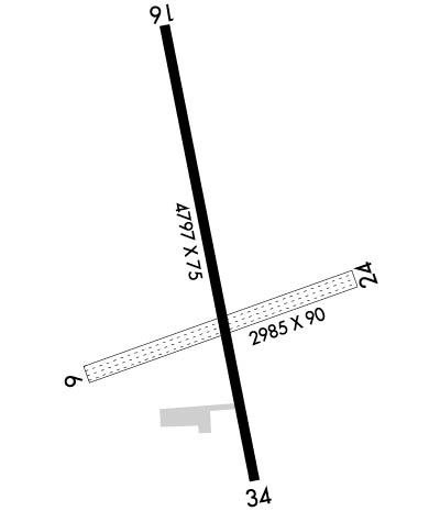
| Lat: N 4324.4 Long: W 09444.8 Elev: 1319 Var: -01 Longest Runway: 4797 | ||
| AWOS: 121.42 CTAF: 122.97 | ||
| ||||||||||||||||||||||||||||||||||||||||||||
| ||||||||||||||||||||||||||||||||||||||||||||
| ||||||||||||||||||||||||||||||||||||||||||||
| Rwy | Rwy | |||||||
| 2989x90 | 2989' | 2989x90 | 2989' | |||||
| 4797x75 | 4797' | 4797x75 | 4797' | |||||
| Runway ID | Single Wheel | Double Wheel | Double Tandem Wheel | Dual Double Wheel |
| 06/24 | N/A | N/A | N/A | N/A |
| 16/34 | 11,000 | N/A | N/A | N/A |
| These numbers are Advisory and are not limits. The Airport Manager should have more accurate Weight Limits | ||||
 Airport Diagram might not be current. | |
| Facility Name: | ESTHERVILLE MUNI |
| City Name: | ESTHERVILLE |
| County: | EMMET |
| State abbrev: | IA |
| State Name: | IOWA |
| Ownership: | PUBLICLY OWNED |
| Use: | OPEN TO THE PUBLIC |
| Owner's Name: | CITY OF ESTHERVILLE |
| Address: | 2 N 7TH ST |
| ESTHERVILLE, IA 51334 | |
| Owner's Phone: | 712-362-7771 |
| Manager's Name: | MATT MCNAE; IOWA LAKES AVIATION |
| Address: | 1672 425TH AVENUE |
| ESTHERVILLE, IA 51334 | |
| Phone: | 712-362-2761 |
| FAA Region: | CENTRAL |
| FAA Field Office: | NONE |
| Date | Sunrise | Sunset |
|---|---|---|
| 06/08/26 Monday | 5:39 | 20:58 |
| 06/09/26 Tuesday | 5:38 | 20:58 |
| 06/10/26 Wednesday | 5:38 | 20:59 |
| 06/11/26 Thursday | 5:38 | 20:59 |
| 06/12/26 Friday | 5:38 | 21:00 |
| 06/13/26 Saturday | 5:38 | 21:00 |
| 06/14/26 Sunday | 5:38 | 21:01 |
| 06/15/26 Monday | 5:38 | 21:01 |
| 06/16/26 Tuesday | 5:38 | 21:02 |
| 06/17/26 Wednesday | 5:38 | 21:02 |
| 06/18/26 Thursday | 5:38 | 21:02 |
| 06/19/26 Friday | 5:38 | 21:03 |
| 06/20/26 Saturday | 5:38 | 21:03 |
| 06/21/26 Sunday | 5:38 | 21:03 |
| Airport Attendance Schedule | 7 Days A Week DAWN-DUSK; FOR SERVICE AFTER HRS CALL 712-362-2761. |
| Airport Status | OPERATIONAL (This Status can change at any time - please check NOTAMS) |
| Airport Lighting Schedule | ACTVT MIRL RY 16/34; REIL RYS 16 & 34; PAPI RYS 16 & 34 - CTAF. |
| Airport Storage Available | NONE |
| Extra Services Available | Charter, Flight Instruction, Aircraft Rental, Aircraft Sales |
| Wind Indicator | YES - (lighted) |
| Control Tower | NO |
| CTAF Frequency | 122.975 |
| Unicom Frequency | 122.975 |
| Rotating Beacon Color | WG |
| Segmented Circle | NO |
| Landing Fee | NO |
| Airport Inspected | STATE - performed by STATE AERONAUTICAL PERSONNEL |
| Inspection Date | 06/21/2023 |
| Type of Fuel Available | Grade 100LL, JET A |
| Airframe Repair Service | MAJOR |
| Power Plant Repair Service | MAJOR |
| Latitude | N4324.4 |
| Longitude | W09444.8 (ESTIMATED) |
| Arpt Elevation | 1318ft (SURVEYED) |
| Magnetic Variation | 01E |
| 4 miles E | of ESTHERVILLE |
| Traffic Pattern Altitude | |
| Sectional Chart | OMAHA |
| Operations (Reported) | Yearly | Avg. Daily |
|---|---|---|
| General Aviation Transient | 0 | 0 |
| General Aviation Local | 0 | 0 |
| Air Taxi | 0 | 0 |
| Commerical | 0 | 0 |
| Commuter | 0 | 0 |
| Military | 0 | 0 |
| Aircraft based on Field | |
|---|---|
| General Aviation Singles | 0 |
| General Aviation Multi | 0 |
| Jet Aircraft | 0 |
| General Aviation Helicopters | 0 |
| Military Aircraft | 0 |
| Gliders | 0 |
| Ultralights | 0 |
| FSS on field | NO |
| FSS tie-in | FORT DODGE |
| FSS Phone | 1-800-WX-BRIEF |
| Who issues Notams | EST |
| Notam D service at airport | YES |
| ARTCC Name | MINNEAPOLIS |
| Airport Certification | |
| Aircraft Rescue & Firefighting Index | None |
| Airport of Entry | No |
| Custom Landing Rights | No |
| Joint Civil/Military | No |
| Military Landing rights | YES |
| NATIONAL PLAN OF INTEGRATED AIRPORT SYSTEMS (NPIAS) |
| GRANT AGREEMENTS UNDER FAAP/ADAP/AIP |
| ASSURANCES PURSUANT TO TITLE VI, CIVIL RIGHTS ACT OF 1964 |
| RY 34 IS CALM WIND RY. |
| FOR CD CTC MINNEAPOLIS ARTCC AT 651-463-5588. |
Airport Communications & Frequencies:
| |||||||||
| Runway: 06 | Runway: 24 | ||
| Mag heading: | 72° | Mag heading: | 252° |
| Rwy Slope: | -.01% Down | Rwy Slope: | .01% Up |
| Approach: | Approach: | ||
| Pattern: | Left Traffic | Pattern: | Left Traffic |
| Markings: | NONE | Markings: | NONE |
| Marking Condition: | FAIR; 06/24 MARKED WITH YELLOW CONES. | Marking Condition: | FAIR |
| Arresting Dev: | Arresting Dev: | ||
| Lat & Long: | N4324.3 W09445.1 | Lat. & Long.: | N4324.4 W09444.4 |
| Elev: | 1312.9 ft. MSL | Elev: | 1312.5 ft. MSL |
| TCH: | TCH: | ||
| Visual Glide Path: | Visual Glide Path: | ||
| Displaced Threshold: | No | Displaced Threshold: | No |
| Touchdown Zone: | YES | Touchdown Zone: | YES |
| Touchdown Elev.: | 1318.3 feet | Touchdown Elev.: | 1318.3 feet |
| Visual Glide Slope: | Visual Glide Slope: | ||
| RVR Equipment: | RVR Equipment: | ||
| RVV Equipment: | NO | RVV Equipment: | NO |
| Approach Lights: | Approach Lights: | ||
| REIL: | NO | REIL: | NO |
| Centerline Lights: | NO | Centerline Lights: | NO |
| Touchdown lights: | NO | Touchdown lights: | NO |
| Runway Category: | Runway with a Visual Approach | Runway Category: | Runway with a Visual Approach |
| Declared Distances: | Declared Distances: | ||
| Obstructions: | Obstructions: | ROAD | |
| Marked: | Marked: | NOT Marked/Lighted | |
| Clearance slope: | 50:1 | Clearance slope: | 38:1 |
| Obstruction height: | Obstruction height: | 15 feet AGL | |
| Dist. from runway: | Dist. from runway: | 575 feet | |
| Centerline offset: | Centerline offset: | ||
| Comments: | Comments: |
| Runway: 16 | Runway: 34 | ||
| Mag heading: | 169° | Mag heading: | 349° |
| Rwy Slope: | .02% Up | Rwy Slope: | -.02% Down |
| Approach: | Approach: | ||
| Pattern: | Left Traffic | Pattern: | Left Traffic |
| Markings: | NONPRECISION INSTRUMENT | Markings: | NONPRECISION INSTRUMENT |
| Marking Condition: | GOOD | Marking Condition: | GOOD |
| Arresting Dev: | Arresting Dev: | ||
| Lat & Long: | N4324.9 W09444.9 | Lat. & Long.: | N4324.1 W09444.7 |
| Elev: | 1316.7 ft. MSL | Elev: | 1317.5 ft. MSL |
| TCH: | 39 ft. AGL | TCH: | 39 ft. AGL |
| Visual Glide Path: | 3.00 degrees | Visual Glide Path: | 3.00 degrees |
| Displaced Threshold: | No | Displaced Threshold: | No |
| Touchdown Zone: | YES | Touchdown Zone: | YES |
| Touchdown Elev.: | 1318.8 feet | Touchdown Elev.: | 1318.7 feet |
| Visual Glide Slope: | 4-Light PAPI on LEFT side of Runway | Visual Glide Slope: | 4-Light PAPI on LEFT side of Runway |
| RVR Equipment: | RVR Equipment: | ||
| RVV Equipment: | NO | RVV Equipment: | NO |
| Approach Lights: | Approach Lights: | ||
| REIL: | YES; REIL ARE OMNIDIRECTIONAL. | REIL: | YES |
| Centerline Lights: | NO | Centerline Lights: | NO |
| Touchdown lights: | NO | Touchdown lights: | NO |
| Runway Category: | Runway with a Non-precision Approach | Runway Category: | Runway with a Non-precision Approach |
| Declared Distances: | Declared Distances: | ||
| Obstructions: | Obstructions: | ROAD | |
| Marked: | Marked: | NOT Marked/Lighted | |
| Clearance slope: | 50:1 | Clearance slope: | 34:1 |
| Obstruction height: | Obstruction height: | 19 feet AGL | |
| Dist. from runway: | Dist. from runway: | 850 feet | |
| Centerline offset: | Centerline offset: | ||
| Comments: | Comments: |
Thanks for using FltPlan.com
all rights reserved © 1999-2026 by Flight Plan LLC
