| EASTON/NEWNAM FIELD EASTON MD |
| |
| Lat: N 3848.2 Long: W 07604.1 Elev: 72 Var: +10 Longest Runway: 5500 | ||
| Clr Del: 119.07 Dept. ATIS: 124.47 Arr. ATIS: 124.47 AWOS: 124.47 Ground: 119.07 Tower: 118.52 | ||
| |||||||||||||||||||||||||||||||||||||||||||||||||||||||||||||||||||||
| |||||||||||||||||||||||||||||||||||||||||||||||||||||||||||||||||||||
| |||||||||||||||||||||||||||||||||||||||||||||||||||||||||||||||||||||
| |||||||||||||||||||||||||||||||||||||||||||||||||||||||||||||||||||||
| |||||||||||||||||||||||||||||||||||||||||||||||||||||||||||||||||||||
| |||||||||||||||||||||||||||||||||||||||||||||||||||||||||||||||||||||
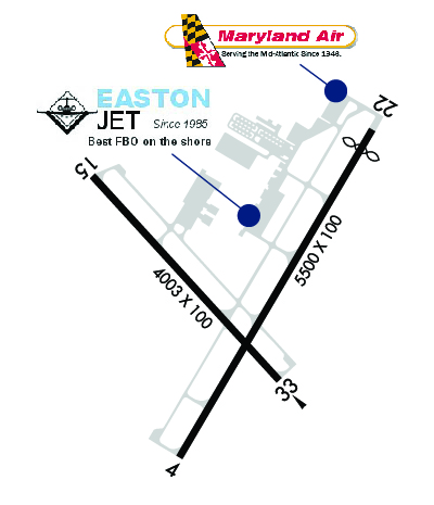
| Rwy | Rwy | |||||||
| 5500x100 | 5500' | 109.35 - 040° | 5500x100 | 5175' | ||||
| 4003x100 | 4003' | 4003x100 | 4003' | |||||
| Runway ID | Single Wheel | Double Wheel | Double Tandem Wheel | Dual Double Wheel |
| 04/22 | 40,000 | 60,000 | 100,000 | N/A |
| 15/33 | 40,000 | 60,000 | 100,000 | N/A |
| These numbers are Advisory and are not limits. The Airport Manager should have more accurate Weight Limits | ||||
 Airport Diagram might not be current. | |
| Facility Name: | EASTON/NEWNAM FLD |
| City Name: | EASTON |
| County: | TALBOT |
| State abbrev: | MD |
| State Name: | MARYLAND |
| Ownership: | PUBLICLY OWNED |
| Use: | OPEN TO THE PUBLIC |
| Owner's Name: | TALBOT CO |
| Address: | TALBOT COUNTY COURT HOUSE, 11 NORTH WASHINGTON STREET |
| EASTON, MD 21601 | |
| Owner's Phone: | 410-770-8082 |
| Manager's Name: | MICAH RISHER |
| Address: | 29051 CORKRAN ROAD |
| EASTON, MD 21601 | |
| Phone: | 410-770-8055 |
| FAA Region: | EASTERN |
| FAA Field Office: | DCA |
| Date | Sunrise | Sunset |
|---|---|---|
| 06/08/26 Monday | 5:39 | 20:28 |
| 06/09/26 Tuesday | 5:39 | 20:28 |
| 06/10/26 Wednesday | 5:39 | 20:29 |
| 06/11/26 Thursday | 5:39 | 20:29 |
| 06/12/26 Friday | 5:39 | 20:30 |
| 06/13/26 Saturday | 5:39 | 20:30 |
| 06/14/26 Sunday | 5:39 | 20:31 |
| 06/15/26 Monday | 5:39 | 20:31 |
| 06/16/26 Tuesday | 5:39 | 20:31 |
| 06/17/26 Wednesday | 5:39 | 20:32 |
| 06/18/26 Thursday | 5:39 | 20:32 |
| 06/19/26 Friday | 5:39 | 20:32 |
| 06/20/26 Saturday | 5:39 | 20:32 |
| 06/21/26 Sunday | 5:39 | 20:33 |
| Airport Attendance Schedule | 7 Days A Week 0800-DUSK |
| Airport Status | OPERATIONAL (This Status can change at any time - please check NOTAMS) |
| Airport Lighting Schedule | WHEN TWR CLSD ACTVT REILS RWY 15, 22, & 33; HIRL RWY 04/22; MIRL RWY 15/33 - CTAF. |
| Airport Storage Available | Tie Downs |
| Extra Services Available | Avionics, Charter, Flight Instruction, Aircraft Rental, Aircraft Sales |
| Wind Indicator | YES - (lighted) |
| Control Tower | YES |
| CTAF Frequency | 118.525 |
| Unicom Frequency | |
| Rotating Beacon Color | WG |
| Segmented Circle | YES |
| Landing Fee | NO |
| Airport Inspected | STATE - performed by STATE AERONAUTICAL PERSONNEL |
| Inspection Date | 07/09/2025 |
| Type of Fuel Available | Grade 100LL, JET A (freeze point -40C) |
| Airframe Repair Service | MAJOR |
| Power Plant Repair Service | MAJOR |
| Latitude | N3848.2 |
| Longitude | W07604.1 (ESTIMATED) |
| Arpt Elevation | 72ft (SURVEYED) |
| Magnetic Variation | 10W |
| 2 miles N | of EASTON |
| Traffic Pattern Altitude | TPA FOR JET ACFT 1526 FT AGL; ALL OTHER ACFT 1026 FT AGL. |
| Sectional Chart | WASHINGTON |
| Operations (Reported) | Yearly | Avg. Daily |
|---|---|---|
| General Aviation Transient | 0 | 0 |
| General Aviation Local | 0 | 0 |
| Air Taxi | 0 | 0 |
| Commerical | 0 | 0 |
| Commuter | 0 | 0 |
| Military | 0 | 0 |
| Aircraft based on Field | |
|---|---|
| General Aviation Singles | 0 |
| General Aviation Multi | 0 |
| Jet Aircraft | 0 |
| General Aviation Helicopters | 0 |
| Military Aircraft | 0 |
| Gliders | 0 |
| Ultralights | 0 |
| FSS on field | NO |
| FSS tie-in | LEESBURG |
| FSS Phone | 1-800-WX-BRIEF |
| Who issues Notams | ESN |
| Notam D service at airport | YES |
| ARTCC Name | WASHINGTON |
| Airport Certification | |
| Aircraft Rescue & Firefighting Index | None |
| Airport of Entry | No |
| Custom Landing Rights | No |
| Joint Civil/Military | No |
| Military Landing rights | YES |
| NATIONAL PLAN OF INTEGRATED AIRPORT SYSTEMS (NPIAS) |
| GRANT AGREEMENTS UNDER FAAP/ADAP/AIP |
| ASSURANCES PURSUANT TO TITLE VI, CIVIL RIGHTS ACT OF 1964 |
| AGREEMENT UNDER DLAND OR DCLA HAS EXPIRED. |
| THIS AIRPORT HAS BEEN SURVEYED BY THE NATIONAL GEODETIC SURVEY. |
| DEER, BIRDS, OTHER WILDLIFE ON & INVOF ARPT. |
| RWY 15/33 DISTANCE MARKERS EVERY 1000 FT WEST SIDE RWY. |
| FOR CD WHEN ATCT IS CLSD CTC POTOMAC APCH AT 866-429-5882. |
| NOISE ABATEMENT FOR RUNWAY 22: CONTINUE STRAIGHT OUT OR MAKE A RIGHT TURN TO AVOID OVERFLIGHT OF THE TOWN OF EASTON. DEPARTURES SHOULD AVOID OVERFLIGHT OF THE TOWN OF EASTON BELOW 2000 FT. |
| AIRCRAFT SHOULD AVOID OVERFLIGHT OF THE TOWN OF EASTON AND RESIDENTIAL AREAS NEAR THE AIRPORT TO THE EXTENT POSSIBLE. |
| NOISE ABATEMENT FOR RUNWAY 4: IF TRAFFIC PERMITS, MAKE A SLIGHT LEFT TURN AFTER DEPARTURE TO AVOID OVERFLYING RETIREMENT COMMUNITY. |
Airport Communications & Frequencies:
| ||||||||||||||||||||||||||||
| Runway: 04 | Runway: 22 | ||
| Mag heading: | 41° | Mag heading: | 221° |
| Rwy Slope: | .66% Up | Rwy Slope: | -.66% Down |
| Approach: | ILS/DME | Approach: | |
| Pattern: | Left Traffic | Pattern: | Right Traffic |
| Markings: | PRECISION INSTRUMENT | Markings: | NONPRECISION INSTRUMENT |
| Marking Condition: | FAIR | Marking Condition: | GOOD |
| Arresting Dev: | Arresting Dev: | ||
| Lat & Long: | N3847.8 W07604.3 | Lat. & Long.: | N3848.6 W07603.7 |
| Elev: | 36.0 ft. MSL | Elev: | 72.2 ft. MSL |
| TCH: | 43 ft. AGL | TCH: | 45 ft. AGL |
| Visual Glide Path: | 3.00 degrees | Visual Glide Path: | 3.00 degrees |
| Displaced Threshold: | No | Displaced Threshold: | 325 feet |
| Touchdown Zone: | YES | Touchdown Zone: | YES |
| Touchdown Elev.: | 57.6 feet | Touchdown Elev.: | 72.2 feet |
| Visual Glide Slope: | 4-Light PAPI on LEFT side of Runway | Visual Glide Slope: | 4-Light PAPI on LEFT side of Runway |
| RVR Equipment: | RVR Equipment: | ||
| RVV Equipment: | NO | RVV Equipment: | NO |
| Approach Lights: | Approach Lights: | ||
| REIL: | NO | REIL: | YES |
| Centerline Lights: | NO | Centerline Lights: | NO |
| Touchdown lights: | NO | Touchdown lights: | NO |
| Runway Category: | Precision Instrument Runway | Runway Category: | Runway with a Non-precision Approach having visibility minimums greater than 3/4 mile |
| Declared Distances: | TORA:5175' TODA:5500' ASDA:4775' LDA:4775' | Declared Distances: | TORA:5500' TODA:5500' ASDA:5500' LDA:5175' |
| Runway: 15 | Runway: 33 | ||
| Mag heading: | 148° | Mag heading: | 328° |
| Rwy Slope: | .46% Up | Rwy Slope: | -.46% Down |
| Approach: | Approach: | ||
| Pattern: | Left Traffic | Pattern: | Right Traffic |
| Markings: | NONPRECISION INSTRUMENT | Markings: | NONPRECISION INSTRUMENT |
| Marking Condition: | FAIR | Marking Condition: | FAIR |
| Arresting Dev: | Arresting Dev: | ||
| Lat & Long: | N3848.5 W07604.6 | Lat. & Long.: | N3848.0 W07604.0 |
| Elev: | 32.6 ft. MSL | Elev: | 51.0 ft. MSL |
| TCH: | 45 ft. AGL | TCH: | 45 ft. AGL |
| Visual Glide Path: | 3.50 degrees | Visual Glide Path: | 3.50 degrees |
| Displaced Threshold: | No | Displaced Threshold: | No |
| Touchdown Zone: | YES | Touchdown Zone: | YES |
| Touchdown Elev.: | 46.6 feet | Touchdown Elev.: | 51.0 feet |
| Visual Glide Slope: | 2-Light PAPI on LEFT side of Runway | Visual Glide Slope: | 2-Light PAPI on LEFT side of Runway |
| RVR Equipment: | RVR Equipment: | ||
| RVV Equipment: | NO | RVV Equipment: | NO |
| Approach Lights: | Approach Lights: | ||
| REIL: | YES | REIL: | YES |
| Centerline Lights: | NO | Centerline Lights: | NO |
| Touchdown lights: | NO | Touchdown lights: | NO |
| Runway Category: | Runway with a Non-precision Approach having visibility minimums greater than 3/4 mile | Runway Category: | Runway with a Non-precision Approach having visibility minimums greater than 3/4 mile |
| Declared Distances: | Declared Distances: | ||
| Obstructions: | Obstructions: | TREES | |
| Marked: | Marked: | NOT Marked/Lighted | |
| Clearance slope: | 34:1 | Clearance slope: | 23:1 |
| Obstruction height: | Obstruction height: | 77 feet AGL | |
| Dist. from runway: | Dist. from runway: | 1999 feet | |
| Centerline offset: | Centerline offset: | 281 feet right of centerline | |
| Comments: | Comments: |
Thanks for using FltPlan.com
all rights reserved © 1999-2026 by Flight Plan LLC