
| DELTA COUNTY ESCANABA MI |
| |
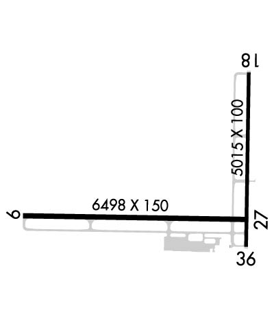
| Lat: N 4543.4 Long: W 08705.6 Elev: 609 Var: +03 Longest Runway: 6498 | ||
| AWOS: 121.42 CTAF: 122.8 | ||
| ||||||
| ||||||
|
| Rwy | Rwy | |||||||
| 5016x100 | 5016' | 5016x100 | 5016' | |||||
| 6498x150 | 6498' | 109.30 - 093° | 6498x150 | 6498' | ||||
| Runway ID | Single Wheel | Double Wheel | Double Tandem Wheel | Dual Double Wheel |
| 01/19 | 40,000 | 60,000 | N/A | N/A |
| 09/27 | 80,000 | 120,000 | 210,000 | N/A |
| These numbers are Advisory and are not limits. The Airport Manager should have more accurate Weight Limits | ||||
 Airport Diagram might not be current. | |
| Facility Name: | DELTA COUNTY |
| City Name: | ESCANABA |
| County: | DELTA |
| State abbrev: | MI |
| State Name: | MICHIGAN |
| Ownership: | PUBLICLY OWNED |
| Use: | OPEN TO THE PUBLIC |
| Owner's Name: | DELTA COUNTY |
| Address: | 310 LUDINGTON ST |
| ESCANABA, MI 49829-4057 | |
| Owner's Phone: | 906-789-5100 |
| Manager's Name: | ANDREA L MICHEAU |
| Address: | DELTA COUNTY AIRPORT, 3300 AIRPORT RD |
| ESCANABA, MI 49829-1057 | |
| Phone: | 906-786-4902 |
| FAA Region: | GREAT LAKES |
| FAA Field Office: | DET |
| Date | Sunrise | Sunset |
|---|---|---|
| 09/24/21 Friday | 7:38 | 19:42 |
| 09/25/21 Saturday | 7:39 | 19:41 |
| 09/26/21 Sunday | 7:40 | 19:39 |
| 09/27/21 Monday | 7:41 | 19:37 |
| 09/28/21 Tuesday | 7:43 | 19:35 |
| 09/29/21 Wednesday | 7:44 | 19:33 |
| 09/30/21 Thursday | 7:45 | 19:31 |
| 10/01/21 Friday | 7:46 | 19:29 |
| 10/02/21 Saturday | 7:48 | 19:27 |
| 10/03/21 Sunday | 7:49 | 19:25 |
| 10/04/21 Monday | 7:50 | 19:23 |
| 10/05/21 Tuesday | 7:51 | 19:21 |
| 10/06/21 Wednesday | 7:53 | 19:19 |
| 10/07/21 Thursday | 7:54 | 19:18 |
| Airport Attendance Schedule | 7 Days A Week 0600-2130; FOR SER CALL ARPT OPS 906-420-1591. |
| Airport Status | OPERATIONAL (This Status can change at any time - please check NOTAMS) |
| Airport Lighting Schedule | ACTVT MALSR RWY 09; REIL RWY 01 & 27; PAPI RWY 27, 01, & 19; HIRL RWY 09/27; MIRL RWY 01/19 - CTAF. |
| Airport Storage Available | Hanger |
| Extra Services Available | Flight Instruction, Aircraft Rental |
| Wind Indicator | YES - (lighted) |
| Control Tower | NO |
| CTAF Frequency | 122.800 |
| Unicom Frequency | 122.800 |
| Rotating Beacon Color | CLEAR-GREEN (Light Land Airport) |
| Segmented Circle | YES |
| Landing Fee | YES; FEE FOR MULTI ENG ACFT. |
| Airport Inspected | FEDERAL - performed by FAA AIRPORTS FIELD PERSONNEL |
| Inspection Date | 09/25/2019 |
| Type of Fuel Available | Grade 100LL, JET A (freeze point -40C); -10100LL AVBL H24 SELF SVC. |
| Airframe Repair Service | MAJOR |
| Power Plant Repair Service | MAJOR |
| Latitude | N4543.4 |
| Longitude | W08705.6 (ESTIMATED) |
| Arpt Elevation | 609ft (SURVEYED) |
| Magnetic Variation | 03W |
| 2 miles SW | of ESCANABA |
| Traffic Pattern Altitude | |
| Sectional Chart | GREEN BAY |
| Operations (Reported) | Yearly | Avg. Daily |
|---|---|---|
| General Aviation Transient | 10000 | 27 |
| General Aviation Local | 20000 | 55 |
| Air Taxi | 7476 | 20 |
| Commerical | 1260 | 3 |
| Commuter | 0 | 0 |
| Military | 250 | 1 |
| Aircraft based on Field | |
|---|---|
| General Aviation Singles | 31 |
| General Aviation Multi | 1 |
| Jet Aircraft | 0 |
| General Aviation Helicopters | 0 |
| Military Aircraft | 0 |
| Gliders | 0 |
| Ultralights | 1 |
| FSS on field | NO |
| FSS tie-in | GREEN BAY |
| FSS Phone | 1-800-WX-BRIEF |
| Who issues Notams | ESC |
| Notam D service at airport | YES |
| ARTCC Name | MINNEAPOLIS |
| Airport Certification | AIRPORT RECEIVING SCHEDULED AIR CARRIER SERVICE FROM CARRIERS CERTIFICATED BY THE CIVIL AERONAUTICS BOARD |
| Aircraft Rescue & Firefighting Index | AIRPORT HAS A CERTIFICATE UNDER CFR PART 139 |
| Airport of Entry | No |
| Custom Landing Rights | No |
| Joint Civil/Military | No |
| Military Landing rights | YES |
| NATIONAL PLAN OF INTEGRATED AIRPORT SYSTEMS (NPIAS) |
| GRANT AGREEMENTS UNDER FAAP/ADAP/AIP |
| ASSURANCES PURSUANT TO TITLE VI, CIVIL RIGHTS ACT OF 1964 |
| FLD CONDS UNMON 2130-0600. |
| FOR CD IF UNA TO CTC ON FSS FREQ, CTC MINNEAPOLIS ARTCC AT 651-463-5588. |
| CLSD TO UNSKED ACR OPS. 1 HR PPR; CALL AMGR 906-241-8504. |
| BIRDS ON & INVOF ARPT. |
Airport Communications & Frequencies:
| |||||||||
| Runway: 01 | Runway: 19 | ||
| Mag heading: | 4° | Mag heading: | 184° |
| Rwy Slope: | .30% Up | Rwy Slope: | -.30% Down |
| Approach: | Approach: | ||
| Pattern: | Left Traffic | Pattern: | Left Traffic |
| Markings: | NONPRECISION INSTRUMENT | Markings: | NONPRECISION INSTRUMENT |
| Marking Condition: | GOOD | Marking Condition: | GOOD |
| Arresting Dev: | Arresting Dev: | ||
| Lat & Long: | N4543.1 W08705.2 | Lat. & Long.: | N4543.9 W08705.2 |
| Elev: | 592.2 ft. MSL | Elev: | 607.0 ft. MSL |
| TCH: | 27 ft. AGL | TCH: | 42 ft. AGL |
| Visual Glide Path: | 3.00 degrees | Visual Glide Path: | 3.00 degrees |
| Displaced Threshold: | No | Displaced Threshold: | No |
| Touchdown Zone: | YES | Touchdown Zone: | YES |
| Touchdown Elev.: | 600.0 feet | Touchdown Elev.: | 607.0 feet |
| Visual Glide Slope: | 4-Light PAPI on LEFT side of Runway | Visual Glide Slope: | 4-Light PAPI on LEFT side of Runway |
| RVR Equipment: | RVR Equipment: | ||
| RVV Equipment: | NO | RVV Equipment: | NO |
| Approach Lights: | Approach Lights: | ||
| REIL: | YES | REIL: | NO |
| Centerline Lights: | NO | Centerline Lights: | NO |
| Touchdown lights: | NO | Touchdown lights: | NO |
| Runway Category: | Runway with a Non-precision Approach having visibility minimums greater than 3/4 mile | Runway Category: | Runway with a Visual Approach |
| Declared Distances: | TORA:5015' TODA:5015' ASDA:5015' LDA:5015' | Declared Distances: | TORA:5015' TODA:5015' ASDA:5015' LDA:5015' |
| Obstructions: | TREE | Obstructions: | |
| Marked: | NOT Marked/Lighted | Marked: | |
| Clearance slope: | 31:1 | Clearance slope: | 20:1 |
| Obstruction height: | 51 feet AGL | Obstruction height: | |
| Dist. from runway: | 1871 feet | Dist. from runway: | |
| Centerline offset: | 61 right of centerline | Centerline offset: | |
| Comments: | Comments: |
| Runway: 09 | Runway: 27 | ||
| Mag heading: | 94° | Mag heading: | 274° |
| Rwy Slope: | -.25% Down | Rwy Slope: | .25% Up |
| Approach: | ILS/DME | Approach: | |
| Pattern: | Left Traffic | Pattern: | Left Traffic |
| Markings: | PRECISION INSTRUMENT | Markings: | PRECISION INSTRUMENT |
| Marking Condition: | FAIR | Marking Condition: | FAIR |
| Arresting Dev: | Arresting Dev: | ||
| Lat & Long: | N4543.2 W08706.7 | Lat. & Long.: | N4543.2 W08705.2 |
| Elev: | 609.1 ft. MSL | Elev: | 593.1 ft. MSL |
| TCH: | TCH: | 53 ft. AGL | |
| Visual Glide Path: | Visual Glide Path: | 3.00 degrees | |
| Displaced Threshold: | No | Displaced Threshold: | No |
| Touchdown Zone: | YES | Touchdown Zone: | YES |
| Touchdown Elev.: | 609.1 feet | Touchdown Elev.: | 596.0 feet |
| Visual Glide Slope: | Visual Glide Slope: | 4-Light PAPI on RIGHT side of Runway | |
| RVR Equipment: | RVR Equipment: | ||
| RVV Equipment: | NO | RVV Equipment: | NO |
| Approach Lights: | MALSR - 1,400 foot medium intensity approach lighting system with runway alignment indicator lights | Approach Lights: | |
| REIL: | NO | REIL: | YES |
| Centerline Lights: | NO | Centerline Lights: | NO |
| Touchdown lights: | NO | Touchdown lights: | NO |
| Runway Category: | Precision Instrument Runway | Runway Category: | Runway with a Non-precision Approach having visibility minimums greater than 3/4 mile |
| Declared Distances: | TORA:6498' TODA:6498' ASDA:6498' LDA:6498' | Declared Distances: | TORA:6498' TODA:6498' ASDA:6498' LDA:6498' |
Thanks for using FltPlan.com
all rights reserved © 1999-2021 by Flight Plan LLC