
| CHARLOTTE-MONROE EXECUTIVE MONROE NC |
| |
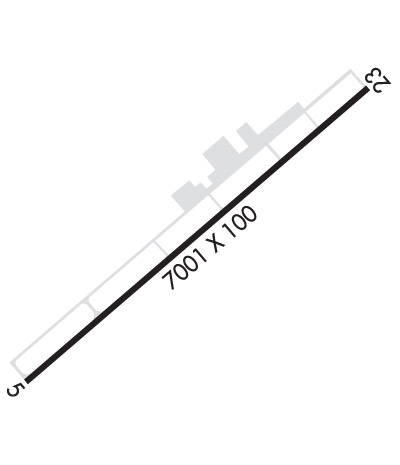
| Lat: N 3501.0 Long: W 08037.3 Elev: 683 Var: +06 Longest Runway: 7001 | ||
| Clr Del: 132.55 AWOS: 135.77 CTAF: 122.7 | ||
| ||||||
| ||||||
|
| Rwy | Rwy | |||||||
| 7001x100 | 7001' | 109.75 - 052° | 7001x100 | 7001' | ||||
| Runway ID | Single Wheel | Double Wheel | Double Tandem Wheel | Dual Double Wheel |
| 05/23 | 35,000 | 68,500 | N/A | N/A |
| These numbers are Advisory and are not limits. The Airport Manager should have more accurate Weight Limits | ||||
 Airport Diagram might not be current. | |
| Facility Name: | CHARLOTTE-MONROE EXEC |
| City Name: | MONROE |
| County: | UNION |
| State abbrev: | NC |
| State Name: | NORTH CAROLINA |
| Ownership: | PUBLICLY OWNED |
| Use: | OPEN TO THE PUBLIC |
| Owner's Name: | CITY OF MONROE |
| Address: | CITY HALL, P.O. BOX 69 |
| MONROE, NC 28111 | |
| Owner's Phone: | (704) 282-4730 |
| Manager's Name: | PETER CEVALLOS |
| Address: | 3900 PAUL J. HELMS DRIVE |
| MONROE, NC 28110 | |
| Phone: | 704-226-2300 |
| FAA Region: | SOUTHERN |
| FAA Field Office: | MEM |

| Date | Sunrise | Sunset |
|---|---|---|
| 09/24/21 Friday | 7:12 | 19:17 |
| 09/25/21 Saturday | 7:12 | 19:15 |
| 09/26/21 Sunday | 7:13 | 19:14 |
| 09/27/21 Monday | 7:14 | 19:12 |
| 09/28/21 Tuesday | 7:15 | 19:11 |
| 09/29/21 Wednesday | 7:16 | 19:10 |
| 09/30/21 Thursday | 7:16 | 19:08 |
| 10/01/21 Friday | 7:17 | 19:07 |
| 10/02/21 Saturday | 7:18 | 19:05 |
| 10/03/21 Sunday | 7:19 | 19:04 |
| 10/04/21 Monday | 7:19 | 19:03 |
| 10/05/21 Tuesday | 7:20 | 19:01 |
| 10/06/21 Wednesday | 7:21 | 19:00 |
| 10/07/21 Thursday | 7:22 | 18:58 |
| Airport Attendance Schedule | 7 Days A Week 0600-2200 |
| Airport Status | OPERATIONAL (This Status can change at any time - please check NOTAMS) |
| Airport Lighting Schedule | ACTVT MALSR RWY 05, REIL RWY 23; HIRL RWY 05/23 - 122.7. ALL LIGHTS OPER DUSK-0000. AFTER 0000, ACTVT - 122.7. PAPI RWY 05 & 23 OPER CONTINUOUSLY. |
| Airport Storage Available | Tie Downs, Hanger |
| Extra Services Available | Avionics, Charter, Flight Instruction, Aircraft Rental, Aircraft Sales |
| Wind Indicator | YES - (lighted) |
| Control Tower | NO |
| CTAF Frequency | 122.700 |
| Unicom Frequency | 122.700 |
| Rotating Beacon Color | CLEAR-GREEN (Light Land Airport) |
| Segmented Circle | YES |
| Landing Fee | NO |
| Airport Inspected | STATE - performed by STATE AERONAUTICAL PERSONNEL |
| Inspection Date | 03/29/2018 |
| Type of Fuel Available | Grade 100LL, JET A-1 (icing inhibitor, freeze point -50C); -10FUEL 24 HR CREDIT CARD SVC AVBL. |
| Airframe Repair Service | MAJOR |
| Power Plant Repair Service | MAJOR |
| Latitude | N3501.0 |
| Longitude | W08037.3 (ESTIMATED) |
| Arpt Elevation | 682ft (SURVEYED) |
| Magnetic Variation | 06W |
| 5 miles NW | of MONROE |
| Traffic Pattern Altitude | |
| Sectional Chart | CHARLOTTE |
| Operations (Reported) | Yearly | Avg. Daily |
|---|---|---|
| General Aviation Transient | 20500 | 56 |
| General Aviation Local | 30500 | 84 |
| Air Taxi | 4100 | 11 |
| Commerical | 0 | 0 |
| Commuter | 0 | 0 |
| Military | 1000 | 3 |
| Aircraft based on Field | |
|---|---|
| General Aviation Singles | 98 |
| General Aviation Multi | 12 |
| Jet Aircraft | 6 |
| General Aviation Helicopters | 0 |
| Military Aircraft | 0 |
| Gliders | 0 |
| Ultralights | 0 |
| FSS on field | NO |
| FSS tie-in | RALEIGH |
| FSS Phone | 1-800-WX-BRIEF |
| Who issues Notams | EQY |
| Notam D service at airport | YES |
| ARTCC Name | ATLANTA |
| Airport Certification | |
| Aircraft Rescue & Firefighting Index | None |
| Airport of Entry | No |
| Custom Landing Rights | No |
| Joint Civil/Military | No |
| Military Landing rights | YES |
| NATIONAL PLAN OF INTEGRATED AIRPORT SYSTEMS (NPIAS) |
| GRANT AGREEMENTS UNDER FAAP/ADAP/AIP |
| ASSURANCES PURSUANT TO TITLE VI, CIVIL RIGHTS ACT OF 1964 |
| ARPT PHONE NUMBER 704-226-2300. |
| DEER, WILDLIFE, AND BIRDS ON AND INVOF ARPT. |
| RESA 23 HAS 20 FT DROPOFF BTN RWY AND TWY A. |
| FOR CD CTC CHARLOTTE APCH AT 704-359-0241. |
Airport Communications & Frequencies:
| ||||||||||||||||
| Runway: 05 | Runway: 23 | ||
| Mag heading: | 53° | Mag heading: | 233° |
| Rwy Slope: | -.29% Down | Rwy Slope: | .29% Up |
| Approach: | ILS/DME | Approach: | |
| Pattern: | Left Traffic | Pattern: | Left Traffic |
| Markings: | PRECISION INSTRUMENT | Markings: | NONPRECISION INSTRUMENT |
| Marking Condition: | GOOD | Marking Condition: | GOOD |
| Arresting Dev: | Arresting Dev: | ||
| Lat & Long: | N3500.7 W08037.8 | Lat. & Long.: | N3501.4 W08036.8 |
| Elev: | 682.5 ft. MSL | Elev: | 662.0 ft. MSL |
| TCH: | 46 ft. AGL | TCH: | 40 ft. AGL |
| Visual Glide Path: | 3.00 degrees | Visual Glide Path: | 3.00 degrees |
| Displaced Threshold: | No | Displaced Threshold: | No |
| Touchdown Zone: | YES | Touchdown Zone: | YES |
| Touchdown Elev.: | 682.5 feet | Touchdown Elev.: | 671.1 feet |
| Visual Glide Slope: | 4-Light PAPI on LEFT side of Runway | Visual Glide Slope: | 4-Light PAPI on LEFT side of Runway |
| RVR Equipment: | RVR Equipment: | ||
| RVV Equipment: | NO | RVV Equipment: | NO |
| Approach Lights: | MALSR - 1,400 foot medium intensity approach lighting system with runway alignment indicator lights | Approach Lights: | |
| REIL: | NO | REIL: | YES |
| Centerline Lights: | NO | Centerline Lights: | NO |
| Touchdown lights: | NO | Touchdown lights: | NO |
| Runway Category: | Precision Instrument Runway | Runway Category: | Runway with a Non-precision Approach having visibility minimums greater than 3/4 mile |
| Declared Distances: | Declared Distances: | ||
| Obstructions: | TREES | Obstructions: | TREES |
| Marked: | NOT Marked/Lighted | Marked: | NOT Marked/Lighted |
| Clearance slope: | 25:1 | Clearance slope: | 17:1 |
| Obstruction height: | 68 feet AGL | Obstruction height: | 50 feet AGL |
| Dist. from runway: | 1918 feet | Dist. from runway: | 1080 feet |
| Centerline offset: | 564 right of centerline | Centerline offset: | 432 feet right of centerline |
| Comments: | Comments: | 60 FT TREES LOCATED 0-200 FT FM THLD AND OFFSET 338 FT LEFT. |
Thanks for using FltPlan.com
all rights reserved © 1999-2021 by Flight Plan LLC