
| EPHRATA MUNI EPHRATA WA |
| |
| Lat: N 4718.5 Long: W 11931.0 Elev: 1276 Var: -16 Longest Runway: 5500 | ||
| AWOS: 135.77 CTAF: 122.8 | ||
| ||||||||||||||||||||||||||||||||||||||||||||
| ||||||||||||||||||||||||||||||||||||||||||||
| ||||||||||||||||||||||||||||||||||||||||||||
| Rwy | Rwy | |||||||
| 5500x75 | 5500' | 5500x75 | 5500' | |||||
| 3467x150 | 3467' | 3467x150 | 3467' | |||||
| 3843x60 | 3843' | 3843x60 | 3843' | |||||
| Runway ID | Single Wheel | Double Wheel | Double Tandem Wheel | Dual Double Wheel |
| 03/21 | 30,000 | 60,000 | N/A | N/A |
| 04/22 | 12,000 | N/A | N/A | N/A |
| 11/29 | 12,000 | N/A | N/A | N/A |
| These numbers are Advisory and are not limits. The Airport Manager should have more accurate Weight Limits | ||||
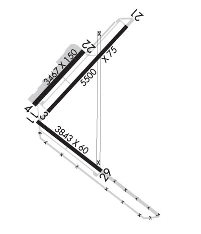 Airport Diagram might not be current. | |
| Facility Name: | EPHRATA MUNI |
| City Name: | EPHRATA |
| County: | GRANT |
| State abbrev: | WA |
| State Name: | WASHINGTON |
| Ownership: | PUBLICLY OWNED |
| Use: | OPEN TO THE PUBLIC |
| Owner's Name: | PORT DIST NO 9 GRANT CO |
| Address: | PORT OF EPHRATA PO BOX 1089 |
| EPHRATA, WA 98823 | |
| Owner's Phone: | 509-754-3508 |
| Manager's Name: | DAVID LANMAN |
| Address: | PO BOX 1089 |
| EPHRATA, WA 98823 | |
| Phone: | 509-754-3508 |
| FAA Region: | NORTHWEST MOUNTAIN |
| FAA Field Office: | SEA |
| Date | Sunrise | Sunset |
|---|---|---|
| 06/08/26 Monday | 5:02 | 20:52 |
| 06/09/26 Tuesday | 5:02 | 20:53 |
| 06/10/26 Wednesday | 5:02 | 20:53 |
| 06/11/26 Thursday | 5:01 | 20:54 |
| 06/12/26 Friday | 5:01 | 20:55 |
| 06/13/26 Saturday | 5:01 | 20:55 |
| 06/14/26 Sunday | 5:01 | 20:56 |
| 06/15/26 Monday | 5:01 | 20:56 |
| 06/16/26 Tuesday | 5:01 | 20:57 |
| 06/17/26 Wednesday | 5:01 | 20:57 |
| 06/18/26 Thursday | 5:01 | 20:57 |
| 06/19/26 Friday | 5:01 | 20:58 |
| 06/20/26 Saturday | 5:01 | 20:58 |
| 06/21/26 Sunday | 5:01 | 20:58 |
| Airport Attendance Schedule | MON-FRI 0700-1600 |
| Airport Status | OPERATIONAL (This Status can change at any time - please check NOTAMS) |
| Airport Lighting Schedule | ACTVT REIL RWYS 3, 11, 21 & 29; MIRL RWY 03/21 & MIRL RWY 11/29 - CTAF. PAPI RWY 29, RWY 03 & RWY 21 OPR CONSLY. |
| Airport Storage Available | Tie Downs, Hanger |
| Extra Services Available | Crop Dusting, Glider |
| Wind Indicator | YES - (lighted) |
| Control Tower | NO |
| CTAF Frequency | 122.800 |
| Unicom Frequency | 122.800; UNICOM MNTD INTMTLY. |
| Rotating Beacon Color | WG |
| Segmented Circle | YES |
| Landing Fee | NO |
| Airport Inspected | STATE - performed by STATE AERONAUTICAL PERSONNEL |
| Inspection Date | 08/19/2025 |
| Type of Fuel Available | Grade 100LL, JET A (freeze point -40C), JET A; -10FUEL 24 HR CREDIT CARD SVC AVBL.; -A+JET-A W/ ADDITIVE AVBL SEVEN DAYS A WEEK 1500Z-2300Z; -A JET-A AVBL SEVEN DAYS A WEEK 1500Z-2300Z. |
| Airframe Repair Service | MINOR |
| Power Plant Repair Service | MINOR |
| Latitude | N4718.5 |
| Longitude | W11931.0 (ESTIMATED) |
| Arpt Elevation | 1276ft (SURVEYED) |
| Magnetic Variation | 16E |
| 2 miles SE | of EPHRATA |
| Traffic Pattern Altitude | |
| Sectional Chart | SEATTLE |
| Operations (Reported) | Yearly | Avg. Daily |
|---|---|---|
| General Aviation Transient | 0 | 0 |
| General Aviation Local | 0 | 0 |
| Air Taxi | 0 | 0 |
| Commerical | 0 | 0 |
| Commuter | 0 | 0 |
| Military | 0 | 0 |
| Aircraft based on Field | |
|---|---|
| General Aviation Singles | 0 |
| General Aviation Multi | 0 |
| Jet Aircraft | 0 |
| General Aviation Helicopters | 0 |
| Military Aircraft | 0 |
| Gliders | 0 |
| Ultralights | 0 |
| FSS on field | NO |
| FSS tie-in | SEATTLE |
| FSS Phone | 1-800-WX-BRIEF |
| Who issues Notams | EPH |
| Notam D service at airport | YES |
| ARTCC Name | SEATTLE |
| Airport Certification | |
| Aircraft Rescue & Firefighting Index | None |
| Airport of Entry | No |
| Custom Landing Rights | No |
| Joint Civil/Military | No |
| Military Landing rights | YES |
| NATIONAL PLAN OF INTEGRATED AIRPORT SYSTEMS (NPIAS) |
| GRANT AGREEMENTS UNDER FAAP/ADAP/AIP |
| SURPLUS PROPERTY AGREEMENT UNDER PUBLIC LAW 289 |
| CONVEYANCE UNDER SCETION 16, FEDERAL AIRPORT ACT OF 1946 OR SECTION 23, AIRPORT AND AIRWAY DEVELOPMENT ACT OF 1970 |
| ASSURANCES PURSUANT TO TITLE VI, CIVIL RIGHTS ACT OF 1964 |
| AGREEMENT UNDER DLAND OR DCLA HAS EXPIRED. |
| BE ALERT AEROBATIC ACFT ACTIVITY OVER CENTER OF AIRPORT. |
| (E81) REFLECTORS ON PORTIONS OF TWYS. |
| CONDS NOT MNT MON-FRI 1600-0700, CONDS NOT MNT SAT-SUN & HOLS 1600-0700. |
| FOR CD IF UNA TO CTC ON FSS FREQ, CTC GRANT COUNTY APCH AT 509-762-2842. WHEN APCH CLSD CTC SEATTLE ARTCC AT 253-351-3694. |
| RWY 04/2 2 RWY 04/22 GLDS USE 1 APR TO 1 NOV. |
Airport Communications & Frequencies:
| |||||||||||||||||
| Runway: 03 | Runway: 21 | ||
| Mag heading: | 27° | Mag heading: | 207° |
| Rwy Slope: | .26% Up | Rwy Slope: | -.26% Down |
| Approach: | Approach: | ||
| Pattern: | Right Traffic | Pattern: | Left Traffic |
| Markings: | NONPRECISION INSTRUMENT | Markings: | NONPRECISION INSTRUMENT |
| Marking Condition: | GOOD | Marking Condition: | GOOD |
| Arresting Dev: | Arresting Dev: | ||
| Lat & Long: | N4718.4 W11931.3 | Lat. & Long.: | N4719.0 W11930.4 |
| Elev: | 1261.4 ft. MSL | Elev: | 1275.5 ft. MSL |
| TCH: | 40 ft. AGL | TCH: | 40 ft. AGL |
| Visual Glide Path: | 3.00 degrees | Visual Glide Path: | 3.00 degrees |
| Displaced Threshold: | No | Displaced Threshold: | No |
| Touchdown Zone: | YES | Touchdown Zone: | YES |
| Touchdown Elev.: | 1269.2 feet | Touchdown Elev.: | 1276.2 feet |
| Visual Glide Slope: | 4-Light PAPI on LEFT side of Runway | Visual Glide Slope: | 4-Light PAPI on LEFT side of Runway |
| RVR Equipment: | RVR Equipment: | ||
| RVV Equipment: | NO | RVV Equipment: | NO |
| Approach Lights: | Approach Lights: | ||
| REIL: | YES | REIL: | YES |
| Centerline Lights: | NO | Centerline Lights: | NO |
| Touchdown lights: | NO | Touchdown lights: | NO |
| Runway Category: | Runway with a Non-precision Approach having visibility minimums greater than 3/4 mile | Runway Category: | Runway with a Non-precision Approach having visibility minimums greater than 3/4 mile |
| Declared Distances: | Declared Distances: | ||
| Obstructions: | GND | Obstructions: | |
| Marked: | NOT Marked/Lighted | Marked: | |
| Clearance slope: | 38:1 | Clearance slope: | 50:1 |
| Obstruction height: | 58 feet AGL | Obstruction height: | |
| Dist. from runway: | 2450 feet | Dist. from runway: | |
| Centerline offset: | 550 left of centerline | Centerline offset: | |
| Comments: | Comments: |
| Runway: 04 | Runway: 22 | ||
| Mag heading: | 26° | Mag heading: | 206° |
| Rwy Slope: | .02% Up | Rwy Slope: | -.02% Down |
| Approach: | Approach: | ||
| Pattern: | Left Traffic | Pattern: | Right Traffic |
| Markings: | NONE | Markings: | NONE |
| Marking Condition: | FAIR | Marking Condition: | FAIR |
| Arresting Dev: | Arresting Dev: | ||
| Lat & Long: | N4718.4 W11931.5 | Lat. & Long.: | N4718.8 W11930.9 |
| Elev: | 1260.9 ft. MSL | Elev: | 1261.5 ft. MSL |
| TCH: | TCH: | ||
| Visual Glide Path: | Visual Glide Path: | ||
| Displaced Threshold: | No | Displaced Threshold: | No |
| Touchdown Zone: | NO | Touchdown Zone: | NO |
| Touchdown Elev.: | Touchdown Elev.: | ||
| Visual Glide Slope: | Visual Glide Slope: | ||
| RVR Equipment: | RVR Equipment: | ||
| RVV Equipment: | NO | RVV Equipment: | NO |
| Approach Lights: | Approach Lights: | ||
| REIL: | NO | REIL: | NO |
| Centerline Lights: | NO | Centerline Lights: | NO |
| Touchdown lights: | NO | Touchdown lights: | NO |
| Runway Category: | Runway with a Visual Approach | Runway Category: | Runway with a Visual Approach |
| Declared Distances: | Declared Distances: |
| Runway: 11 | Runway: 29 | ||
| Mag heading: | 112° | Mag heading: | 292° |
| Rwy Slope: | -.10% Down | Rwy Slope: | .10% Up |
| Approach: | Approach: | ||
| Pattern: | Left Traffic | Pattern: | Left Traffic |
| Markings: | BASIC | Markings: | BASIC |
| Marking Condition: | GOOD | Marking Condition: | GOOD |
| Arresting Dev: | Arresting Dev: | ||
| Lat & Long: | N4718.3 W11931.4 | Lat. & Long.: | N4717.9 W11930.7 |
| Elev: | 1261.3 ft. MSL | Elev: | 1257.3 ft. MSL |
| TCH: | TCH: | 40 ft. AGL | |
| Visual Glide Path: | Visual Glide Path: | 3.00 degrees | |
| Displaced Threshold: | No | Displaced Threshold: | No |
| Touchdown Zone: | YES | Touchdown Zone: | YES |
| Touchdown Elev.: | 1263.0 feet | Touchdown Elev.: | 1263.0 feet |
| Visual Glide Slope: | Visual Glide Slope: | 2-Light PAPI on LEFT side of Runway | |
| RVR Equipment: | RVR Equipment: | ||
| RVV Equipment: | NO | RVV Equipment: | NO |
| Approach Lights: | Approach Lights: | ||
| REIL: | YES | REIL: | YES |
| Centerline Lights: | NO | Centerline Lights: | NO |
| Touchdown lights: | NO | Touchdown lights: | NO |
| Runway Category: | Runway with a Visual Approach | Runway Category: | Runway with a Visual Approach |
| Declared Distances: | Declared Distances: | ||
| Obstructions: | GND | Obstructions: | |
| Marked: | NOT Marked/Lighted | Marked: | |
| Clearance slope: | 28:1 | Clearance slope: | 50:1 |
| Obstruction height: | 52 feet AGL | Obstruction height: | |
| Dist. from runway: | 1666 feet | Dist. from runway: | |
| Centerline offset: | 293 left of centerline | Centerline offset: | |
| Comments: | Comments: |
Thanks for using FltPlan.com
all rights reserved © 1999-2026 by Flight Plan LLC
