
| WENDOVER WENDOVER UT |
| |
| Lat: N 4043.1 Long: W 11401.7 Elev: 4237 Var: -12 Longest Runway: 10002 | ||
| AWOS: 120.55 CTAF: 122.8 | ||
| ||||||||||||||||||||||||||||||||||||||||||||
| ||||||||||||||||||||||||||||||||||||||||||||
| ||||||||||||||||||||||||||||||||||||||||||||
| Rwy | Rwy | |||||||
| 10002x150 | 10002' | 10002x150 | 10002' | |||||
| 8002x100 | 8002' | 8002x100 | 8002' | |||||
| Runway ID | Single Wheel | Double Wheel | Double Tandem Wheel | Dual Double Wheel |
| 08/26 | 75,000 | 140,000 | 208,000 | N/A |
| 12/30 | 75,000 | 140,000 | 180,000 | N/A |
| These numbers are Advisory and are not limits. The Airport Manager should have more accurate Weight Limits | ||||
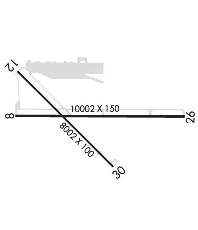 Airport Diagram might not be current. | |
| Facility Name: | WENDOVER |
| City Name: | WENDOVER |
| County: | TOOELE |
| State abbrev: | UT |
| State Name: | UTAH |
| Ownership: | PUBLICLY OWNED |
| Use: | OPEN TO THE PUBLIC |
| Owner's Name: | TOOELE COUNTY |
| Address: | P.O. BOX 159 |
| WENDOVER, UT 84083 | |
| Owner's Phone: | 435-843-3360 |
| Manager's Name: | LISA DUNN |
| Address: | P.O. BOX 159 |
| WENDOVER, UT 84083 | |
| Phone: | 435-843-3360 |
| FAA Region: | NORTHWEST MOUNTAIN |
| FAA Field Office: | DEN |
| Date | Sunrise | Sunset |
|---|---|---|
| 06/08/26 Monday | 6:05 | 21:06 |
| 06/09/26 Tuesday | 6:05 | 21:06 |
| 06/10/26 Wednesday | 6:05 | 21:07 |
| 06/11/26 Thursday | 6:04 | 21:07 |
| 06/12/26 Friday | 6:04 | 21:08 |
| 06/13/26 Saturday | 6:04 | 21:08 |
| 06/14/26 Sunday | 6:04 | 21:09 |
| 06/15/26 Monday | 6:04 | 21:09 |
| 06/16/26 Tuesday | 6:04 | 21:09 |
| 06/17/26 Wednesday | 6:04 | 21:10 |
| 06/18/26 Thursday | 6:04 | 21:10 |
| 06/19/26 Friday | 6:05 | 21:10 |
| 06/20/26 Saturday | 6:05 | 21:11 |
| 06/21/26 Sunday | 6:05 | 21:11 |
| Airport Attendance Schedule | 7 Days A Week 0800-1800 |
| Airport Status | OPERATIONAL (This Status can change at any time - please check NOTAMS) |
| Airport Lighting Schedule | ACTVT REIL RWY 08, 12, 26, 30; PAPI RWY 08, 26, 30; MIRL RWY 08/26 & 12/30 - CTAF. |
| Airport Storage Available | Hanger |
| Extra Services Available | NONE |
| Wind Indicator | YES - (unlit) |
| Control Tower | NO |
| CTAF Frequency | 122.800 |
| Unicom Frequency | 122.800 |
| Rotating Beacon Color | WG |
| Segmented Circle | YES |
| Landing Fee | NO |
| Airport Inspected | FEDERAL - performed by FAA AIRPORTS FIELD PERSONNEL |
| Inspection Date | 02/25/2026 |
| Type of Fuel Available | Grade 100, JET A (freeze point -40C) |
| Airframe Repair Service | MINOR |
| Power Plant Repair Service | MINOR |
| Latitude | N4043.1 |
| Longitude | W11401.7 (ESTIMATED) |
| Arpt Elevation | 4236ft (SURVEYED) |
| Magnetic Variation | 12E |
| 1 miles SE | of WENDOVER |
| Traffic Pattern Altitude | |
| Sectional Chart | SALT LAKE CITY |
| Operations (Reported) | Yearly | Avg. Daily |
|---|---|---|
| General Aviation Transient | 0 | 0 |
| General Aviation Local | 0 | 0 |
| Air Taxi | 0 | 0 |
| Commerical | 0 | 0 |
| Commuter | 0 | 0 |
| Military | 0 | 0 |
| Aircraft based on Field | |
|---|---|
| General Aviation Singles | 0 |
| General Aviation Multi | 0 |
| Jet Aircraft | 0 |
| General Aviation Helicopters | 0 |
| Military Aircraft | 0 |
| Gliders | 0 |
| Ultralights | 0 |
| FSS on field | NO |
| FSS tie-in | CEDAR CITY |
| FSS Phone | 1-800-WX-BRIEF |
| Who issues Notams | ENV |
| Notam D service at airport | YES |
| ARTCC Name | SALT LAKE CITY |
| Airport Certification | 24 HR PPR FOR ACFT OPNS WITH MORE THAN 30 PAX CALL AMGR 775-778-1891 OR 801-520-1613. WHEN REQD ARPT WILL MNTN ARFF INDEX B. |
| Aircraft Rescue & Firefighting Index | AIRPORT HAS A CERTIFICATE UNDER CFR PART 139 |
| Airport of Entry | No |
| Custom Landing Rights | No |
| Joint Civil/Military | No |
| Military Landing rights | YES |
| NATIONAL PLAN OF INTEGRATED AIRPORT SYSTEMS (NPIAS) |
| SURPLUS PROPERTY AGREEMENT UNDER PUBLIC LAW 289 |
| ASSURANCES PURSUANT TO TITLE VI, CIVIL RIGHTS ACT OF 1964 |
| COLD TEMPERATURE AIRPORT. ALTITUDE CORRECTION REQUIRED AT OR BELOW -12C. |
| ALL SFCS AVBL TO ACRS. |
| RWY 08/2 6 PCR VALUE: 490/F/D/X/T |
| RWY 12/3 0 PCR VALUE: 560/F/D/X/T |
Airport Communications & Frequencies:
| |||||||||
| Runway: 08 | Runway: 26 | ||
| Mag heading: | 78° | Mag heading: | 258° |
| Rwy Slope: | -.03% Down | Rwy Slope: | .03% Up |
| Approach: | Approach: | ||
| Pattern: | Right Traffic | Pattern: | Left Traffic |
| Markings: | PRECISION INSTRUMENT | Markings: | PRECISION INSTRUMENT |
| Marking Condition: | GOOD | Marking Condition: | GOOD |
| Arresting Dev: | Arresting Dev: | ||
| Lat & Long: | N4043.1 W11402.6 | Lat. & Long.: | N4043.1 W11400.4 |
| Elev: | 4229.7 ft. MSL | Elev: | 4226.4 ft. MSL |
| TCH: | 40 ft. AGL | TCH: | 50 ft. AGL |
| Visual Glide Path: | 3.00 degrees | Visual Glide Path: | 3.00 degrees |
| Displaced Threshold: | No | Displaced Threshold: | No |
| Touchdown Zone: | YES | Touchdown Zone: | YES |
| Touchdown Elev.: | 4230.2 feet | Touchdown Elev.: | 4226.6 feet |
| Visual Glide Slope: | 4-Light PAPI on LEFT side of Runway | Visual Glide Slope: | 4-Light PAPI on LEFT side of Runway |
| RVR Equipment: | RVR Equipment: | ||
| RVV Equipment: | NO | RVV Equipment: | NO |
| Approach Lights: | Approach Lights: | ||
| REIL: | YES | REIL: | YES |
| Centerline Lights: | NO | Centerline Lights: | NO |
| Touchdown lights: | NO | Touchdown lights: | NO |
| Runway Category: | Runway with a Non-precision Approach having visibility minimums greater than 3/4 mile | Runway Category: | Runway with a Non-precision Approach having visibility minimums greater than 3/4 mile |
| Declared Distances: | TORA:10002' TODA:10002' ASDA:10002' LDA:10002' | Declared Distances: | TORA:10002' TODA:10002' ASDA:10002' LDA:10002' |
| Runway: 12 | Runway: 30 | ||
| Mag heading: | 123° | Mag heading: | 303° |
| Rwy Slope: | -.15% Down | Rwy Slope: | .15% Up |
| Approach: | Approach: | ||
| Pattern: | Right Traffic | Pattern: | Left Traffic |
| Markings: | NONPRECISION INSTRUMENT | Markings: | NONPRECISION INSTRUMENT |
| Marking Condition: | GOOD | Marking Condition: | GOOD |
| Arresting Dev: | Arresting Dev: | ||
| Lat & Long: | N4043.6 W11402.6 | Lat. & Long.: | N4042.6 W11401.4 |
| Elev: | 4236.7 ft. MSL | Elev: | 4224.3 ft. MSL |
| TCH: | TCH: | 45 ft. AGL | |
| Visual Glide Path: | Visual Glide Path: | 3.00 degrees | |
| Displaced Threshold: | No | Displaced Threshold: | No |
| Touchdown Zone: | YES | Touchdown Zone: | YES |
| Touchdown Elev.: | 4236.7 feet | Touchdown Elev.: | 4227.1 feet |
| Visual Glide Slope: | Visual Glide Slope: | 4-Light PAPI on LEFT side of Runway | |
| RVR Equipment: | RVR Equipment: | ||
| RVV Equipment: | NO | RVV Equipment: | NO |
| Approach Lights: | Approach Lights: | ||
| REIL: | YES | REIL: | YES |
| Centerline Lights: | NO | Centerline Lights: | NO |
| Touchdown lights: | NO | Touchdown lights: | NO |
| Runway Category: | Runway with a Visual Approach | Runway Category: | Runway with a Visual Approach |
| Declared Distances: | TORA:8002' TODA:8002' ASDA:8002' LDA:8002' | Declared Distances: | TORA:8002' TODA:8002' ASDA:8002' LDA:8002' |
Thanks for using FltPlan.com
all rights reserved © 1999-2026 by Flight Plan LLC
