
| CENTRALIA MUNI CENTRALIA IL |
| |
| Lat: N 3830.9 Long: W 08905.5 Elev: 534 Var: +02 Longest Runway: 5001 | ||
| AWOS: 121.12 CTAF: 122.8 | ||
| |||||||||||||||||||||||||||||||||||||||||||||||||||||||||||||
| |||||||||||||||||||||||||||||||||||||||||||||||||||||||||||||
| |||||||||||||||||||||||||||||||||||||||||||||||||||||||||||||
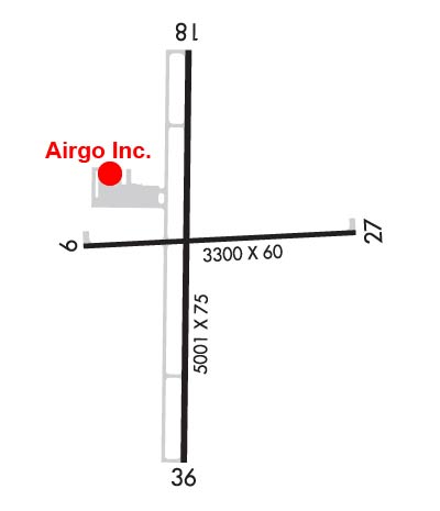
| Rwy | Rwy | |||||||
| 3300x60 | 3300' | 3300x60 | 3300' | |||||
| 5001x75 | 5001' | 5001x75 | 5001' | |||||
| Runway ID | Single Wheel | Double Wheel | Double Tandem Wheel | Dual Double Wheel |
| 09/27 | 12,500 | N/A | N/A | N/A |
| 18/36 | 30,000 | 40,000 | N/A | N/A |
| These numbers are Advisory and are not limits. The Airport Manager should have more accurate Weight Limits | ||||
 Airport Diagram might not be current. | |
| Facility Name: | CENTRALIA MUNI |
| City Name: | CENTRALIA |
| County: | MARION |
| State abbrev: | IL |
| State Name: | ILLINOIS |
| Ownership: | PUBLICLY OWNED |
| Use: | OPEN TO THE PUBLIC |
| Owner's Name: | CITY OF CENTRALIA |
| Address: | 101 S. LOCUST |
| CENTRALIA, IL 62801 | |
| Owner's Phone: | (618) 533-7622 |
| Manager's Name: | GALEN MAHLE |
| Address: | 2331 E. CALUMET; EMAIL ADDRESS: GMAHLE@CITYOFCENTRALIA.ORG (ALL LOWER CASE) |
| CENTRALIA, IL 62801 | |
| Phone: | 618-533-7622; CELL # 618-267-7844 |
| FAA Region: | GREAT LAKES |
| FAA Field Office: | CHI |
| Date | Sunrise | Sunset |
|---|---|---|
| 06/08/26 Monday | 5:32 | 20:19 |
| 06/09/26 Tuesday | 5:32 | 20:19 |
| 06/10/26 Wednesday | 5:32 | 20:20 |
| 06/11/26 Thursday | 5:32 | 20:20 |
| 06/12/26 Friday | 5:32 | 20:21 |
| 06/13/26 Saturday | 5:32 | 20:21 |
| 06/14/26 Sunday | 5:32 | 20:22 |
| 06/15/26 Monday | 5:32 | 20:22 |
| 06/16/26 Tuesday | 5:32 | 20:22 |
| 06/17/26 Wednesday | 5:32 | 20:23 |
| 06/18/26 Thursday | 5:32 | 20:23 |
| 06/19/26 Friday | 5:32 | 20:23 |
| 06/20/26 Saturday | 5:32 | 20:24 |
| 06/21/26 Sunday | 5:32 | 20:24 |
| Airport Attendance Schedule | 7 Days A Week 0800-DUSK; FOR SVC AFT HRS CALL (920) 728-4417. |
| Airport Status | OPERATIONAL (This Status can change at any time - please check NOTAMS) |
| Airport Lighting Schedule | ACTVT MIRL RY 09/27, RY 18/36 & REIL RY 18/36 - CTAF. |
| Airport Storage Available | Tie Downs |
| Extra Services Available | Charter, Flight Instruction, Aircraft Rental, Aircraft Sales |
| Wind Indicator | YES - (lighted) |
| Control Tower | NO |
| CTAF Frequency | 122.800 |
| Unicom Frequency | 122.800 |
| Rotating Beacon Color | WG |
| Segmented Circle | Y-L |
| Landing Fee | NO |
| Airport Inspected | STATE - performed by STATE AERONAUTICAL PERSONNEL |
| Inspection Date | 09/11/2025 |
| Type of Fuel Available | Grade 100LL, JET A (freeze point -40C) |
| Airframe Repair Service | None |
| Power Plant Repair Service | None |
| Latitude | N3830.9 |
| Longitude | W08905.5 (ESTIMATED) |
| Arpt Elevation | 534ft (ESTIMATED) |
| Magnetic Variation | 02W |
| 2 miles SE | of CENTRALIA |
| Traffic Pattern Altitude | |
| Sectional Chart | ST LOUIS |
| Operations (Reported) | Yearly | Avg. Daily |
|---|---|---|
| General Aviation Transient | 0 | 0 |
| General Aviation Local | 0 | 0 |
| Air Taxi | 0 | 0 |
| Commerical | 0 | 0 |
| Commuter | 0 | 0 |
| Military | 0 | 0 |
| Aircraft based on Field | |
|---|---|
| General Aviation Singles | 0 |
| General Aviation Multi | 0 |
| Jet Aircraft | 0 |
| General Aviation Helicopters | 0 |
| Military Aircraft | 0 |
| Gliders | 0 |
| Ultralights | 0 |
| FSS on field | NO |
| FSS tie-in | SAINT LOUIS |
| FSS Phone | 1-800-WX-BRIEF |
| Who issues Notams | ENL |
| Notam D service at airport | YES |
| ARTCC Name | KANSAS CITY |
| Airport Certification | |
| Aircraft Rescue & Firefighting Index | None |
| Airport of Entry | No |
| Custom Landing Rights | No |
| Joint Civil/Military | No |
| Military Landing rights | YES |
| NATIONAL PLAN OF INTEGRATED AIRPORT SYSTEMS (NPIAS) |
| GRANT AGREEMENTS UNDER FAAP/ADAP/AIP |
| ASSURANCES PURSUANT TO TITLE VI, CIVIL RIGHTS ACT OF 1964 |
| FOR CD IF UNA TO CTC ON FSS FREQ, CTC KANSAS CITY ARTCC AT 913-254-8508. |
Airport Communications & Frequencies:
| |||||||||
| Runway: 09 | Runway: 27 | ||
| Mag heading: | 89° | Mag heading: | 269° |
| Rwy Slope: | -.06% Down | Rwy Slope: | .06% Up |
| Approach: | Approach: | ||
| Pattern: | Right Traffic | Pattern: | Left Traffic |
| Markings: | BASIC | Markings: | BASIC |
| Marking Condition: | POOR; RWY 9 MARKING POOR. | Marking Condition: | POOR; RWY 27 MARKINGS FADED. |
| Arresting Dev: | Arresting Dev: | ||
| Lat & Long: | N3830.9 W08905.8 | Lat. & Long.: | N3830.9 W08905.1 |
| Elev: | 521.9 ft. MSL | Elev: | 519.9 ft. MSL |
| TCH: | TCH: | ||
| Visual Glide Path: | Visual Glide Path: | ||
| Displaced Threshold: | No | Displaced Threshold: | No |
| Touchdown Zone: | YES | Touchdown Zone: | YES |
| Touchdown Elev.: | 522.3 feet | Touchdown Elev.: | 522.3 feet |
| Visual Glide Slope: | Visual Glide Slope: | ||
| RVR Equipment: | RVR Equipment: | ||
| RVV Equipment: | NO | RVV Equipment: | NO |
| Approach Lights: | Approach Lights: | ||
| REIL: | NO | REIL: | NO |
| Centerline Lights: | NO | Centerline Lights: | NO |
| Touchdown lights: | NO | Touchdown lights: | NO |
| Runway Category: | Runway with a Visual Approach | Runway Category: | Runway with a Visual Approach |
| Declared Distances: | Declared Distances: | ||
| Obstructions: | ROAD | Obstructions: | |
| Marked: | NOT Marked/Lighted | Marked: | |
| Clearance slope: | 20:1 | Clearance slope: | 20:1 |
| Obstruction height: | 13 feet AGL | Obstruction height: | |
| Dist. from runway: | 470 feet | Dist. from runway: | |
| Centerline offset: | Centerline offset: | ||
| Comments: | Comments: |
| Runway: 18 | Runway: 36 | ||
| Mag heading: | 183° | Mag heading: | 2° |
| Rwy Slope: | .30% Up | Rwy Slope: | -.30% Down |
| Approach: | Approach: | ||
| Pattern: | Left Traffic | Pattern: | Right Traffic |
| Markings: | NONPRECISION INSTRUMENT | Markings: | NONPRECISION INSTRUMENT |
| Marking Condition: | GOOD | Marking Condition: | FAIR |
| Arresting Dev: | Arresting Dev: | ||
| Lat & Long: | N3831.3 W08905.5 | Lat. & Long.: | N3830.5 W08905.5 |
| Elev: | 519.3 ft. MSL | Elev: | 534.1 ft. MSL |
| TCH: | 44 ft. AGL | TCH: | 45 ft. AGL |
| Visual Glide Path: | 3.00 degrees | Visual Glide Path: | 3.00 degrees |
| Displaced Threshold: | No | Displaced Threshold: | No |
| Touchdown Zone: | YES | Touchdown Zone: | YES |
| Touchdown Elev.: | 524.6 feet | Touchdown Elev.: | 534.1 feet |
| Visual Glide Slope: | 2-Light PAPI on LEFT side of Runway | Visual Glide Slope: | 2-Light PAPI on LEFT side of Runway |
| RVR Equipment: | RVR Equipment: | ||
| RVV Equipment: | NO | RVV Equipment: | NO |
| Approach Lights: | Approach Lights: | ||
| REIL: | YES | REIL: | YES |
| Centerline Lights: | NO | Centerline Lights: | NO |
| Touchdown lights: | NO | Touchdown lights: | NO |
| Runway Category: | Runway with a Non-precision Approach having visibility minimums greater than 3/4 mile | Runway Category: | Runway with a Non-precision Approach having visibility minimums greater than 3/4 mile |
| Declared Distances: | Declared Distances: | ||
| Obstructions: | TREE | Obstructions: | |
| Marked: | NOT Marked/Lighted | Marked: | |
| Clearance slope: | 28:1 | Clearance slope: | 34:1 |
| Obstruction height: | 49 feet AGL | Obstruction height: | |
| Dist. from runway: | 1608 feet | Dist. from runway: | |
| Centerline offset: | 56 left of centerline | Centerline offset: | |
| Comments: | Comments: |
Thanks for using FltPlan.com
all rights reserved © 1999-2026 by Flight Plan LLC

