
| VANCE AFB ENID OK |
| |
| Lat: N 3620.4 Long: W 09755.0 Elev: 1313 Var: -05 Longest Runway: 9217 | ||
| Dept. ATIS: 115.4 Arr. ATIS: 115.4 Ground: 121.8 Tower: 124.05 | ||
| ||||||
|
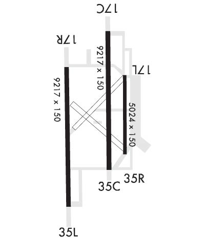
| Rwy | Rwy | |||||||
| 9217x150 | 9217' | 108.90 - 172° | 9217x150 | 9217' | 110.10 - 351° | |||
| 5024x150 | 5024' | 5024x150 | 5024' | |||||
| 9217x150 | 9217' | 9217x150 | 9217' | |||||
| Runway ID | Single Wheel | Double Wheel | Double Tandem Wheel | Dual Double Wheel |
| 17C/35C | N/A | N/A | N/A | N/A |
| 17L/35R | N/A | N/A | N/A | N/A |
| 17R/35L | N/A | N/A | N/A | N/A |
| These numbers are Advisory and are not limits. The Airport Manager should have more accurate Weight Limits | ||||
 Airport Diagram might not be current. | |
| Facility Name: | VANCE AFB |
| City Name: | ENID |
| County: | GARFIELD |
| State abbrev: | OK |
| State Name: | OKLAHOMA |
| Ownership: | AIR FORCE OWNED |
| Use: | PRIVATE |
| Owner's Name: | U.S. AIR FORCE |
| Address: | 71 FTW, VANCE AFB |
| ENID, OK 73705 | |
| Owner's Phone: | 580-213-7101 |
| Manager's Name: | LAWRENCE FRANKLIN |
| Address: | 71FTW VANCE AFB, VANCE AFB |
| ENID, OK 73705 | |
| Phone: | 580-213-7424 |
| FAA Region: | SOUTHWEST |
| FAA Field Office: | AOK |
| Date | Sunrise | Sunset |
|---|---|---|
| 09/24/21 Friday | 7:21 | 19:26 |
| 09/25/21 Saturday | 7:22 | 19:24 |
| 09/26/21 Sunday | 7:23 | 19:23 |
| 09/27/21 Monday | 7:23 | 19:21 |
| 09/28/21 Tuesday | 7:24 | 19:20 |
| 09/29/21 Wednesday | 7:25 | 19:18 |
| 09/30/21 Thursday | 7:26 | 19:17 |
| 10/01/21 Friday | 7:27 | 19:15 |
| 10/02/21 Saturday | 7:27 | 19:14 |
| 10/03/21 Sunday | 7:28 | 19:13 |
| 10/04/21 Monday | 7:29 | 19:11 |
| 10/05/21 Tuesday | 7:30 | 19:10 |
| 10/06/21 Wednesday | 7:31 | 19:08 |
| 10/07/21 Thursday | 7:32 | 19:07 |
| Airport Attendance Schedule | MON-FRI 1300-0200Z, SUN 1900-2300Z (DT 2000-0000Z); CLSD SAT & FED HOL; OTR TIMES BY NOTAM. |
| Airport Status | OPERATIONAL (This Status can change at any time - please check NOTAMS) |
| Airport Lighting Schedule | SS-SR |
| Airport Storage Available | Hanger |
| Extra Services Available | Cargo Handling |
| Wind Indicator | YES - (unlit) |
| Control Tower | YES |
| CTAF Frequency | |
| Unicom Frequency | |
| Rotating Beacon Color | CLEAR-GREEN (Light Land Airport) |
| Segmented Circle | NO |
| Landing Fee |
| Airport Inspected | No Inspection Data Available performed by the OWNER |
| Inspection Date | Unknown |
| Type of Fuel Available | JET B (wide-cut turbine fuel, icing inhibitor, freeze point -50C) |
| Airframe Repair Service | MAJOR |
| Power Plant Repair Service | MAJOR |
| Latitude | N3620.4 |
| Longitude | W09755.0 (ESTIMATED) |
| Arpt Elevation | 1312ft (SURVEYED) |
| Magnetic Variation | 05E |
| 3 miles S | of ENID |
| Traffic Pattern Altitude | |
| Sectional Chart | WICHITA |
| Operations (Reported) | Yearly | Avg. Daily |
|---|---|---|
| General Aviation Transient | 0 | 0 |
| General Aviation Local | 0 | 0 |
| Air Taxi | 0 | 0 |
| Commerical | 0 | 0 |
| Commuter | 0 | 0 |
| Military | 100000 | 274 |
| Aircraft based on Field | |
|---|---|
| General Aviation Singles | 0 |
| General Aviation Multi | 0 |
| Jet Aircraft | 0 |
| General Aviation Helicopters | 0 |
| Military Aircraft | 2 |
| Gliders | 0 |
| Ultralights | 0 |
| FSS on field | NO |
| FSS tie-in | MC ALESTER |
| FSS Phone | 1-800-WX-BRIEF |
| Who issues Notams | MLC |
| Notam D service at airport | YES |
| ARTCC Name | KANSAS CITY |
| Airport Certification | |
| Aircraft Rescue & Firefighting Index | None |
| Airport of Entry | No |
| Custom Landing Rights | No |
| Joint Civil/Military | No |
| Military Landing rights | No |
| BEARING STRENGTH RWY 04-22: ST127 SBTT379 DDT547. |
| BEARING STRENGTH RWY 17L-35R: TRT544. |
| BEARING STRENGTH RWY 17R-35L: TRT540. |
| BEARING STRENGTH RWY 17C-35C: SBTT535 DDT790 TRT469. |
| MISC: DV CODE 7 OR HYR ARR CTC VANCE OPS 20 MIN PRIOR TO ETA. |
| MISC: WX OBS LMTD ALL QUAD; ALL EOR NOT VIS FM OBS PT; WHEN FOG AND/OR LO CLOUDS OVR AER 17/35 COND RPT FM OBS PT MAY NOT BE REPRESENTATIVE. |
| SEE FLIP AP/1 SUPPLEMENTARY ARPT INFO. |
| JASU: 8(A/M32A-86) 10(AM32-95). |
| FLUID: SP PRESAIR LPOX LOX. |
| OIL: O-148-156 SOAP. |
| TRAN ALERT: AVBL DURG PUBL/NOTAM OPS HRS; NO FLEET SVC AVBL; TSNT DEICING UNAVBL. |
| CTN: SOME OBST LGT NSTD; ONLY VIS TO 3 MI. |
| CTN: ACFT SUNSHADES 735 FT E OF RWY 17L/35R. |
| CTN: BARRIERS NOT CONNECTED TO ENERGY ABSORBER AT AER. |
| RSTD: PPR CTC VANCE AFLD OPS DSN 448-7425, C580-213-7425. |
| CTN: LED OBST LGTS MAY NOT BE VIS NVD OR NGT VISION GOGGLES. |
| AWOS DURG OPS HR; OBS AUGMENTED. |
| WIND SOCK UNLGTD WHEN RWY UNLGTD. |
| RSTD: DURG VMC DEP RMN BLW 2300 FT UNTIL DER TO ENSURE SEPN FM VFR OVHD PAT UNLESS OTRW CLEARED BY ATC. |
| RWY 17C/ 35CFIRST 3350 FT RWY 17C AND FIRST 1000 FT RWY 35C IS GROOVED CONC, MID 4950 FT IS GROOVED ASPH. |
| RWY 17L/ 35RMID 2000 FT IS GROOVED. |
Airport Communications & Frequencies:
| |||||||||||||||||||||||||||||||||||||||||||||||||||||||||||||
| Runway: 17C | Runway: 35C | ||
| Mag heading: | 175° | Mag heading: | 355° |
| Rwy Slope: | .18% Up | Rwy Slope: | -.18% Down |
| Approach: | LOC/GS | Approach: | ILS |
| Pattern: | Left Traffic | Pattern: | Left Traffic |
| Markings: | PRECISION INSTRUMENT | Markings: | PRECISION INSTRUMENT |
| Marking Condition: | GOOD | Marking Condition: | GOOD |
| Arresting Dev: | MA-1A; BAK-15 CHAG (154 FT OVRN). | Arresting Dev: | MA-1A; BAK-15 CHAG (154 FT OVRN). |
| Lat & Long: | N3621.3 W09754.9 | Lat. & Long.: | N3619.8 W09754.9 |
| Elev: | 1275.7 ft. MSL | Elev: | 1292.6 ft. MSL |
| TCH: | 51 ft. AGL | TCH: | 41 ft. AGL |
| Visual Glide Path: | 2.50 degrees | Visual Glide Path: | 2.50 degrees |
| Displaced Threshold: | No | Displaced Threshold: | No |
| Touchdown Zone: | YES | Touchdown Zone: | YES |
| Touchdown Elev.: | 1277.0 feet | Touchdown Elev.: | 1292.6 feet |
| Visual Glide Slope: | 4-Light PAPI on LEFT side of Runway; 4-LGT PAPI LCTD BOTH SIDES OF RWY 17C. | Visual Glide Slope: | 4-Light PAPI on LEFT side of Runway; 4-LGT PAPI LCTD BOTH SIDES OF RWY 35C. |
| RVR Equipment: | TOUCHDOWN | RVR Equipment: | TOUCHDOWN |
| RVV Equipment: | NO | RVV Equipment: | NO |
| Approach Lights: | SALSF; NSTD; INSTALLED ON PRECISION RWY. | Approach Lights: | SALSF; NSTD; INSTALLED ON PRECISION RWY. |
| REIL: | NO | REIL: | NO |
| Centerline Lights: | NO | Centerline Lights: | NO |
| Touchdown lights: | NO | Touchdown lights: | NO |
| Runway Category: | Runway Category: | ||
| Declared Distances: | Declared Distances: |
| Runway: 17L | Runway: 35R | ||
| Mag heading: | 175° | Mag heading: | 355° |
| Rwy Slope: | .22% Up | Rwy Slope: | -.22% Down |
| Approach: | Approach: | ||
| Pattern: | Left Traffic | Pattern: | Left Traffic |
| Markings: | NONSTANDARD | Markings: | NONSTANDARD |
| Marking Condition: | GOOD | Marking Condition: | GOOD |
| Arresting Dev: | Arresting Dev: | ||
| Lat & Long: | N3620.8 W09754.7 | Lat. & Long.: | N3620.0 W09754.7 |
| Elev: | 1272.6 ft. MSL | Elev: | 1283.9 ft. MSL |
| TCH: | 54 ft. AGL | TCH: | 50 ft. AGL |
| Visual Glide Path: | 3.00 degrees | Visual Glide Path: | 3.00 degrees |
| Displaced Threshold: | No | Displaced Threshold: | No |
| Touchdown Zone: | YES | Touchdown Zone: | YES |
| Touchdown Elev.: | 1281.6 feet | Touchdown Elev.: | 1284.0 feet |
| Visual Glide Slope: | 4-Light PAPI on LEFT side of Runway | Visual Glide Slope: | 4-Light PAPI on LEFT side of Runway; PAPI UNUSBL BYD 9 DEGS RIGHT AND LEFT OF CNTRLN. |
| RVR Equipment: | RVR Equipment: | ||
| RVV Equipment: | NO | RVV Equipment: | NO |
| Approach Lights: | Approach Lights: | ||
| REIL: | YES | REIL: | NO |
| Centerline Lights: | NO | Centerline Lights: | NO |
| Touchdown lights: | NO | Touchdown lights: | NO |
| Runway Category: | Runway Category: | ||
| Declared Distances: | Declared Distances: |
| Runway: 17R | Runway: 35L | ||
| Mag heading: | 175° | Mag heading: | 355° |
| Rwy Slope: | .34% Up | Rwy Slope: | -.34% Down |
| Approach: | Approach: | ||
| Pattern: | Left Traffic | Pattern: | Left Traffic |
| Markings: | PRECISION INSTRUMENT | Markings: | PRECISION INSTRUMENT |
| Marking Condition: | GOOD | Marking Condition: | GOOD |
| Arresting Dev: | MA-1A; BAK-15 CHAG (152 FT OVRN). | Arresting Dev: | MA-1A; BAK-15 CHAG (152 FT OVRN). |
| Lat & Long: | N3621.0 W09755.4 | Lat. & Long.: | N3619.4 W09755.4 |
| Elev: | 1275.1 ft. MSL | Elev: | 1306.6 ft. MSL |
| TCH: | 48 ft. AGL | TCH: | 49 ft. AGL |
| Visual Glide Path: | 2.50 degrees | Visual Glide Path: | 2.50 degrees |
| Displaced Threshold: | No | Displaced Threshold: | No |
| Touchdown Zone: | YES | Touchdown Zone: | YES |
| Touchdown Elev.: | 1286.7 feet | Touchdown Elev.: | 1306.6 feet |
| Visual Glide Slope: | 4-Light PAPI on LEFT side of Runway; 4-LGT PAPI LCTD BOTH SIDES OF RWY 17R. | Visual Glide Slope: | 4-Light PAPI on LEFT side of Runway; 4-LGT PAPI LCTD BOTH SIDES OF RWY 35L. |
| RVR Equipment: | RVR Equipment: | ||
| RVV Equipment: | NO | RVV Equipment: | NO |
| Approach Lights: | SALS | Approach Lights: | SALS |
| REIL: | NO | REIL: | NO |
| Centerline Lights: | NO | Centerline Lights: | NO |
| Touchdown lights: | NO | Touchdown lights: | NO |
| Runway Category: | Runway Category: | ||
| Declared Distances: | Declared Distances: |
Thanks for using FltPlan.com
all rights reserved © 1999-2021 by Flight Plan LLC
