| EMPORIA-GREENSVILLE RGNL EMPORIA VA |
| |
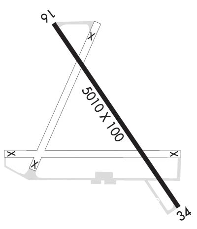
| Lat: N 3641.2 Long: W 07729.0 Elev: 127 Var: +10 Longest Runway: 5010 | ||
| AWOS: 124.17 CTAF: 123.0 | ||
| |||||||||||||||||||||||
| |||||||||||||||||||||||
| |||||||||||||||||||||||
| Rwy | Rwy | |||||||
| 5010x100 | 5010' | 5010x100 | 5010' | 108.75 - 335° | ||||
| Runway ID | Single Wheel | Double Wheel | Double Tandem Wheel | Dual Double Wheel |
| 16/34 | 30,000 | 50,000 | 85,000 | N/A |
| These numbers are Advisory and are not limits. The Airport Manager should have more accurate Weight Limits | ||||
 Airport Diagram might not be current. | |
| Facility Name: | EMPORIA-GREENSVILLE RGNL |
| City Name: | EMPORIA |
| County: | GREENSVILLE |
| State abbrev: | VA |
| State Name: | VIRGINIA |
| Ownership: | PUBLICLY OWNED |
| Use: | OPEN TO THE PUBLIC |
| Owner's Name: | EMPORIA-GREENSVILLE ARPT COMM |
| Address: | 139 AIRPORT DR |
| EMPORIA, VA 23847 | |
| Owner's Phone: | 804-370-2203 |
| Manager's Name: | MELVIN VICK |
| Address: | 139 AIRPORT DR. |
| EMPORIA, VA 23847 | |
| Phone: | 434-634-3696 |
| FAA Region: | EASTERN |
| FAA Field Office: | DCA |
| Date | Sunrise | Sunset |
|---|---|---|
| 09/24/21 Friday | 6:59 | 19:04 |
| 09/25/21 Saturday | 7:00 | 19:03 |
| 09/26/21 Sunday | 7:01 | 19:01 |
| 09/27/21 Monday | 7:02 | 19:00 |
| 09/28/21 Tuesday | 7:02 | 18:58 |
| 09/29/21 Wednesday | 7:03 | 18:57 |
| 09/30/21 Thursday | 7:04 | 18:55 |
| 10/01/21 Friday | 7:05 | 18:54 |
| 10/02/21 Saturday | 7:06 | 18:52 |
| 10/03/21 Sunday | 7:07 | 18:51 |
| 10/04/21 Monday | 7:07 | 18:49 |
| 10/05/21 Tuesday | 7:08 | 18:48 |
| 10/06/21 Wednesday | 7:09 | 18:46 |
| 10/07/21 Thursday | 7:10 | 18:45 |
| Airport Attendance Schedule | 7 Days A Week 0900-1700 |
| Airport Status | OPERATIONAL (This Status can change at any time - please check NOTAMS) |
| Airport Lighting Schedule | ACTIVATE REIL RWY 16 & 34; PAPI RWY 16 & 34; MIRL RWY 16/34 - CTAF. |
| Airport Storage Available | Tie Downs, Hanger |
| Extra Services Available | Crop Dusting, Flight Instruction |
| Wind Indicator | YES - (lighted) |
| Control Tower | NO |
| CTAF Frequency | 123.000 |
| Unicom Frequency | 123.000 |
| Rotating Beacon Color | CLEAR-GREEN (Light Land Airport) |
| Segmented Circle | YES |
| Landing Fee | NO |
| Airport Inspected | STATE - performed by STATE AERONAUTICAL PERSONNEL |
| Inspection Date | 01/07/2021 |
| Type of Fuel Available | Grade 100LL, JET A (freeze point -40C) |
| Airframe Repair Service | None |
| Power Plant Repair Service | None |
| Latitude | N3641.2 |
| Longitude | W07729.0 (ESTIMATED) |
| Arpt Elevation | 126ft (SURVEYED) |
| Magnetic Variation | 10W |
| 3 miles E | of EMPORIA |
| Traffic Pattern Altitude | TPA LGT ACFT 1,000 FT, HVY ACFT 1,500 FT. |
| Sectional Chart | WASHINGTON |
| Operations (Reported) | Yearly | Avg. Daily |
|---|---|---|
| General Aviation Transient | 897 | 2 |
| General Aviation Local | 393 | 1 |
| Air Taxi | 72 | 0 |
| Commerical | 0 | 0 |
| Commuter | 0 | 0 |
| Military | 72 | 0 |
| Aircraft based on Field | |
|---|---|
| General Aviation Singles | 11 |
| General Aviation Multi | 1 |
| Jet Aircraft | 0 |
| General Aviation Helicopters | 0 |
| Military Aircraft | 0 |
| Gliders | 0 |
| Ultralights | 0 |
| FSS on field | NO |
| FSS tie-in | LEESBURG |
| FSS Phone | 1-800-WX-BRIEF |
| Who issues Notams | EMV |
| Notam D service at airport | YES |
| ARTCC Name | WASHINGTON |
| Airport Certification | |
| Aircraft Rescue & Firefighting Index | None |
| Airport of Entry | No |
| Custom Landing Rights | No |
| Joint Civil/Military | No |
| Military Landing rights | YES |
| NATIONAL PLAN OF INTEGRATED AIRPORT SYSTEMS (NPIAS) |
| GRANT AGREEMENTS UNDER FAAP/ADAP/AIP |
| ASSURANCES PURSUANT TO TITLE VI, CIVIL RIGHTS ACT OF 1964 |
| AGREEMENT UNDER DLAND OR DCLA HAS EXPIRED. |
| DEER ON & INVOF ARPT. |
| FOR CD CTC WASHINGTON ARTCC AT 703-771-3587. |
Airport Communications & Frequencies:
| |||||||||
| Runway: 16 | Runway: 34 | ||
| Mag heading: | 155° | Mag heading: | 335° |
| Rwy Slope: | -.33% Down | Rwy Slope: | .33% Up |
| Approach: | Approach: | LOC/DME | |
| Pattern: | Left Traffic | Pattern: | Left Traffic |
| Markings: | NONPRECISION INSTRUMENT | Markings: | NONPRECISION INSTRUMENT |
| Marking Condition: | GOOD | Marking Condition: | GOOD |
| Arresting Dev: | Arresting Dev: | ||
| Lat & Long: | N3641.6 W07729.3 | Lat. & Long.: | N3640.9 W07728.7 |
| Elev: | 126.6 ft. MSL | Elev: | 109.9 ft. MSL |
| TCH: | 31 ft. AGL | TCH: | 43 ft. AGL |
| Visual Glide Path: | 3.00 degrees | Visual Glide Path: | 3.00 degrees |
| Displaced Threshold: | No | Displaced Threshold: | No |
| Touchdown Zone: | YES | Touchdown Zone: | YES |
| Touchdown Elev.: | 126.7 feet | Touchdown Elev.: | 122.3 feet |
| Visual Glide Slope: | 2-Light PAPI on LEFT side of Runway; RY 16 PAPI UNUSABLE BYD 7 DEG LEFT & RIGHT ON CNTRLINE. | Visual Glide Slope: | 2-Light PAPI on LEFT side of Runway; RY 34 PAPI UNUSABLE BYD 8 DEG RIGHT OF CENERLINE. |
| RVR Equipment: | RVR Equipment: | ||
| RVV Equipment: | NO | RVV Equipment: | NO |
| Approach Lights: | Approach Lights: | ||
| REIL: | YES | REIL: | YES |
| Centerline Lights: | NO | Centerline Lights: | NO |
| Touchdown lights: | NO | Touchdown lights: | NO |
| Runway Category: | Runway with a Non-precision Approach having visibility minimums greater than 3/4 mile | Runway Category: | Runway with a Non-precision Approach having visibility minimums greater than 3/4 mile |
| Declared Distances: | Declared Distances: | ||
| Obstructions: | ROAD | Obstructions: | TREE |
| Marked: | LIGHTED | Marked: | LIGHTED |
| Clearance slope: | 9:1 | Clearance slope: | 38:1 |
| Obstruction height: | 15 feet AGL | Obstruction height: | 50 feet AGL |
| Dist. from runway: | 336 feet | Dist. from runway: | 2117 feet |
| Centerline offset: | 263 right of centerline | Centerline offset: | 285 feet right of centerline |
| Comments: | Comments: |
Thanks for using FltPlan.com
all rights reserved © 1999-2021 by Flight Plan LLC