
| SOUTH ARKANSAS RGNL AT GOODWIN EL DORADO AR |
| |
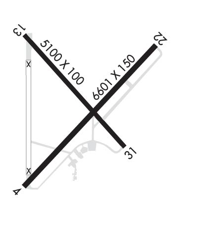
| Lat: N 3313.3 Long: W 09248.7 Elev: 277 Var: -03 Longest Runway: 6601 | ||
| AWOS: 118.32 CTAF: 123.0 | ||
| ||||||||||||||||||||||||||||||||||||||||||||
| ||||||||||||||||||||||||||||||||||||||||||||
| ||||||||||||||||||||||||||||||||||||||||||||
| Rwy | Rwy | |||||||
| 6601x150 | 6601' | 6601x150 | 6601' | 111.10 - 222° | ||||
| 5100x100 | 5100' | 5100x100 | 5100' | |||||
| Runway ID | Single Wheel | Double Wheel | Double Tandem Wheel | Dual Double Wheel |
| 04/22 | 75,000 | 200,000 | N/A | N/A |
| 13/31 | 25,000 | N/A | N/A | N/A |
| These numbers are Advisory and are not limits. The Airport Manager should have more accurate Weight Limits | ||||
 Airport Diagram might not be current. | |
| Facility Name: | SOUTH ARKANSAS RGNL AT GOODWIN FLD |
| City Name: | EL DORADO |
| County: | UNION |
| State abbrev: | AR |
| State Name: | ARKANSAS |
| Ownership: | PUBLICLY OWNED |
| Use: | OPEN TO THE PUBLIC |
| Owner's Name: | CITY OF EL DORADO |
| Address: | PO BOX 2170 |
| EL DORADO, AR 71731 | |
| Owner's Phone: | 870-862-7911 |
| Manager's Name: | JOHNATHAN ESTES |
| Address: | 418 AIRPORT DR. |
| EL DORADO, AR 71730 | |
| Phone: | 870-881-4192 |
| FAA Region: | SOUTHWEST |
| FAA Field Office: | AOK |
| Date | Sunrise | Sunset |
|---|---|---|
| 09/24/21 Friday | 7:01 | 19:05 |
| 09/25/21 Saturday | 7:01 | 19:04 |
| 09/26/21 Sunday | 7:02 | 19:03 |
| 09/27/21 Monday | 7:03 | 19:01 |
| 09/28/21 Tuesday | 7:03 | 19:00 |
| 09/29/21 Wednesday | 7:04 | 18:59 |
| 09/30/21 Thursday | 7:05 | 18:57 |
| 10/01/21 Friday | 7:05 | 18:56 |
| 10/02/21 Saturday | 7:06 | 18:55 |
| 10/03/21 Sunday | 7:07 | 18:53 |
| 10/04/21 Monday | 7:07 | 18:52 |
| 10/05/21 Tuesday | 7:08 | 18:51 |
| 10/06/21 Wednesday | 7:09 | 18:49 |
| 10/07/21 Thursday | 7:10 | 18:48 |
| Airport Attendance Schedule | MON-FRI 0600-2000, SUN 1100-1800, SAT 1030-2000; FOR SVC AFT HRS CALL 870-312-6255; FEE CHRGD. |
| Airport Status | OPERATIONAL (This Status can change at any time - please check NOTAMS) |
| Airport Lighting Schedule | DUSK-DAWN. HIRL RY 04/22 PRESET LOW INTST; TO INCR INTST & ACTVT MIRL RY 13/31; MALSR RY 22 & TWY LGTS - CTAF. |
| Airport Storage Available | Tie Downs, Hanger |
| Extra Services Available | Air Ambulance, Flight Instruction, Aircraft Rental |
| Wind Indicator | YES - (lighted) |
| Control Tower | NO |
| CTAF Frequency | 123.000 |
| Unicom Frequency | 123.000 |
| Rotating Beacon Color | CLEAR-GREEN (Light Land Airport) |
| Segmented Circle | NO |
| Landing Fee | NO |
| Airport Inspected | STATE - performed by STATE AERONAUTICAL PERSONNEL |
| Inspection Date | 08/25/2020 |
| Type of Fuel Available | Grade 100LL, JET A (freeze point -40C) |
| Airframe Repair Service | MAJOR |
| Power Plant Repair Service | MAJOR |
| Latitude | N3313.3 |
| Longitude | W09248.7 (ESTIMATED) |
| Arpt Elevation | 276ft (SURVEYED) |
| Magnetic Variation | 03E |
| 8 miles W | of EL DORADO |
| Traffic Pattern Altitude | |
| Sectional Chart | MEMPHIS |
| Operations (Reported) | Yearly | Avg. Daily |
|---|---|---|
| General Aviation Transient | 5000 | 14 |
| General Aviation Local | 9000 | 25 |
| Air Taxi | 1500 | 4 |
| Commerical | 2000 | 5 |
| Commuter | 0 | 0 |
| Military | 520 | 1 |
| Aircraft based on Field | |
|---|---|
| General Aviation Singles | 11 |
| General Aviation Multi | 2 |
| Jet Aircraft | 5 |
| General Aviation Helicopters | 1 |
| Military Aircraft | 0 |
| Gliders | 0 |
| Ultralights | 0 |
| FSS on field | NO |
| FSS tie-in | JONESBORO |
| FSS Phone | 1-800-WX-BRIEF |
| Who issues Notams | ELD |
| Notam D service at airport | YES |
| ARTCC Name | FORT WORTH |
| Airport Certification | |
| Aircraft Rescue & Firefighting Index | None |
| Airport of Entry | No |
| Custom Landing Rights | No |
| Joint Civil/Military | No |
| Military Landing rights | YES |
| NATIONAL PLAN OF INTEGRATED AIRPORT SYSTEMS (NPIAS) |
| GRANT AGREEMENTS UNDER FAAP/ADAP/AIP |
| ASSURANCES PURSUANT TO TITLE VI, CIVIL RIGHTS ACT OF 1964 |
| AGREEMENT UNDER DLAND OR DCLA HAS EXPIRED. |
| THIS AIRPORT HAS BEEN SURVEYED BY THE NATIONAL GEODETIC SURVEY. |
| FOR CD IF UNA TO CTC ON FSS FREQ, CTC FORT WORTH ARTCC AT 817-858-7584. |
Airport Communications & Frequencies:
| |||||||||
| Runway: 04 | Runway: 22 | ||
| Mag heading: | 43° | Mag heading: | 223° |
| Rwy Slope: | .01% Up | Rwy Slope: | -.01% Down |
| Approach: | Approach: | ILS/DME | |
| Pattern: | Left Traffic | Pattern: | Left Traffic |
| Markings: | PRECISION INSTRUMENT | Markings: | PRECISION INSTRUMENT |
| Marking Condition: | FAIR | Marking Condition: | FAIR |
| Arresting Dev: | Arresting Dev: | ||
| Lat & Long: | N3312.8 W09249.1 | Lat. & Long.: | N3313.6 W09248.2 |
| Elev: | 258.7 ft. MSL | Elev: | 259.4 ft. MSL |
| TCH: | 50 ft. AGL | TCH: | 53 ft. AGL |
| Visual Glide Path: | 3.00 degrees | Visual Glide Path: | 3.00 degrees |
| Displaced Threshold: | No | Displaced Threshold: | No |
| Touchdown Zone: | YES | Touchdown Zone: | YES |
| Touchdown Elev.: | 260.2 feet | Touchdown Elev.: | 259.4 feet |
| Visual Glide Slope: | 4-Light PAPI on LEFT side of Runway | Visual Glide Slope: | 4-Light PAPI on LEFT side of Runway |
| RVR Equipment: | RVR Equipment: | ||
| RVV Equipment: | NO | RVV Equipment: | NO |
| Approach Lights: | Approach Lights: | MALSR - 1,400 foot medium intensity approach lighting system with runway alignment indicator lights | |
| REIL: | NO | REIL: | NO |
| Centerline Lights: | NO | Centerline Lights: | NO |
| Touchdown lights: | NO | Touchdown lights: | NO |
| Runway Category: | Runway with a Non-precision Approach having visibility minimums greater than 3/4 mile | Runway Category: | Precision Instrument Runway |
| Declared Distances: | Declared Distances: | ||
| Obstructions: | TREES | Obstructions: | |
| Marked: | NOT Marked/Lighted | Marked: | |
| Clearance slope: | 35:1 | Clearance slope: | 50:1 |
| Obstruction height: | 40 feet AGL | Obstruction height: | |
| Dist. from runway: | 1600 feet | Dist. from runway: | |
| Centerline offset: | 400 right of centerline | Centerline offset: | |
| Comments: | Comments: |
| Runway: 13 | Runway: 31 | ||
| Mag heading: | 133° | Mag heading: | 313° |
| Rwy Slope: | -.66% Down | Rwy Slope: | .66% Up |
| Approach: | Approach: | ||
| Pattern: | Left Traffic | Pattern: | Left Traffic |
| Markings: | NONPRECISION INSTRUMENT | Markings: | NONPRECISION INSTRUMENT |
| Marking Condition: | POOR; MARKINGS FADED | Marking Condition: | POOR; MARKINGS FADED |
| Arresting Dev: | Arresting Dev: | ||
| Lat & Long: | N3313.7 W09249.1 | Lat. & Long.: | N3313.0 W09248.4 |
| Elev: | 276.8 ft. MSL | Elev: | 243.2 ft. MSL |
| TCH: | 43 ft. AGL | TCH: | 43 ft. AGL |
| Visual Glide Path: | 4.00 degrees | Visual Glide Path: | 4.00 degrees |
| Displaced Threshold: | No | Displaced Threshold: | No |
| Touchdown Zone: | YES | Touchdown Zone: | YES |
| Touchdown Elev.: | 276.8 feet | Touchdown Elev.: | 260.7 feet |
| Visual Glide Slope: | 2-Light PAPI on LEFT side of Runway; PAPI UNUSBL BYD 9 DEGS LEFT AND 6 DEGS RIGHT OF CNTRLN. | Visual Glide Slope: | 2-Light PAPI on RIGHT side of Runway; PAPI UNUSBL BYD 7 DEGS LEFT AND RIGHT OF CNTRLN. |
| RVR Equipment: | RVR Equipment: | ||
| RVV Equipment: | NO | RVV Equipment: | NO |
| Approach Lights: | Approach Lights: | ||
| REIL: | NO | REIL: | NO |
| Centerline Lights: | NO | Centerline Lights: | NO |
| Touchdown lights: | NO | Touchdown lights: | NO |
| Runway Category: | Runway with a Visual Approach | Runway Category: | Runway with a Visual Approach |
| Declared Distances: | Declared Distances: | ||
| Obstructions: | TREES | Obstructions: | TREE |
| Marked: | NOT Marked/Lighted | Marked: | NOT Marked/Lighted |
| Clearance slope: | 34:1 | Clearance slope: | 38:1 |
| Obstruction height: | 33 feet AGL | Obstruction height: | 45 feet AGL |
| Dist. from runway: | 1350 feet | Dist. from runway: | 1950 feet |
| Centerline offset: | Centerline offset: | ||
| Comments: | Comments: |
Thanks for using FltPlan.com
all rights reserved © 1999-2021 by Flight Plan LLC
