| ELKINS-RANDOLPH CO/JENNINGS-RA ELKINS WV |
| |
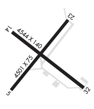
| Lat: N 3853.4 Long: W 07951.4 Elev: 1987 Var: +07 Longest Runway: 4544 | ||
| AWOS: 119.27 CTAF: 123.6 | ||
| ||||||||||||||||||||||||||||||||||||||||||||||||||||||||||||||||||||
| ||||||||||||||||||||||||||||||||||||||||||||||||||||||||||||||||||||
| ||||||||||||||||||||||||||||||||||||||||||||||||||||||||||||||||||||
| Rwy | Rwy | |||||||
| 4501x75 | 4347' | 4501x75 | 4501' | |||||
| 4544x140 | 4544' | 4544x140 | 3154' | |||||
| Runway ID | Single Wheel | Double Wheel | Double Tandem Wheel | Dual Double Wheel |
| 00X | N/A | N/A | N/A | N/A |
| 05/23 | 28,000 | 35,000 | 56,000 | N/A |
| 14/32 | 10,000 | N/A | N/A | N/A |
| These numbers are Advisory and are not limits. The Airport Manager should have more accurate Weight Limits | ||||
 Airport Diagram might not be current. | |
| Facility Name: | ELKINS-RANDOLPH COUNTY-JENNINGS RANDOLPH FLD |
| City Name: | ELKINS |
| County: | RANDOLPH |
| State abbrev: | WV |
| State Name: | WEST VIRGINIA |
| Ownership: | PUBLICLY OWNED |
| Use: | OPEN TO THE PUBLIC |
| Owner's Name: | ELKINS-RANDOLPH CO RGNL ARPT AUTH |
| Address: | 400 AIRPORT RD |
| ELKINS, WV 26241 | |
| Owner's Phone: | 304-636-2726 |
| Manager's Name: | MARY ALICE RICOTTILLI |
| Address: | 400 AIRPORT RD |
| ELKINS, WV 26241 | |
| Phone: | 304-636-2726 |
| FAA Region: | EASTERN |
| FAA Field Office: | BKW |
| Date | Sunrise | Sunset |
|---|---|---|
| 09/24/21 Friday | 7:09 | 19:14 |
| 09/25/21 Saturday | 7:10 | 19:12 |
| 09/26/21 Sunday | 7:10 | 19:10 |
| 09/27/21 Monday | 7:11 | 19:09 |
| 09/28/21 Tuesday | 7:12 | 19:07 |
| 09/29/21 Wednesday | 7:13 | 19:06 |
| 09/30/21 Thursday | 7:14 | 19:04 |
| 10/01/21 Friday | 7:15 | 19:03 |
| 10/02/21 Saturday | 7:16 | 19:01 |
| 10/03/21 Sunday | 7:17 | 18:59 |
| 10/04/21 Monday | 7:18 | 18:58 |
| 10/05/21 Tuesday | 7:19 | 18:56 |
| 10/06/21 Wednesday | 7:20 | 18:55 |
| 10/07/21 Thursday | 7:21 | 18:53 |
| Airport Attendance Schedule | 7 Days A Week 0830-1700 |
| Airport Status | OPERATIONAL (This Status can change at any time - please check NOTAMS) |
| Airport Lighting Schedule | ACTVT MIRL RY 05/23 & REIL RY 23 - 122.9. |
| Airport Storage Available | Tie Downs, Hanger |
| Extra Services Available | Flight Instruction |
| Wind Indicator | YES - (lighted) |
| Control Tower | NO |
| CTAF Frequency | 123.600 |
| Unicom Frequency | |
| Rotating Beacon Color | CLEAR-GREEN (Light Land Airport) |
| Segmented Circle | NO |
| Landing Fee | NO |
| Airport Inspected | STATE - performed by PRIVATE CONTRACT PERSONNEL |
| Inspection Date | 07/11/2021 |
| Type of Fuel Available | Grade 100LL, JET A (freeze point -40C); -A ALL FUELING 24HR SELF SERVICE |
| Airframe Repair Service | None |
| Power Plant Repair Service | None |
| Latitude | N3853.4 |
| Longitude | W07951.4 (ESTIMATED) |
| Arpt Elevation | 1987ft (SURVEYED) |
| Magnetic Variation | 07W |
| 2 miles S | of ELKINS |
| Traffic Pattern Altitude | 1013 |
| Sectional Chart | CINCINNATI |
| Operations (Reported) | Yearly | Avg. Daily |
|---|---|---|
| General Aviation Transient | 3000 | 8 |
| General Aviation Local | 7000 | 19 |
| Air Taxi | 0 | 0 |
| Commerical | 0 | 0 |
| Commuter | 0 | 0 |
| Military | 500 | 1 |
| Aircraft based on Field | |
|---|---|
| General Aviation Singles | 23 |
| General Aviation Multi | 4 |
| Jet Aircraft | 1 |
| General Aviation Helicopters | 0 |
| Military Aircraft | 0 |
| Gliders | 0 |
| Ultralights | 0 |
| FSS on field | NO |
| FSS tie-in | ELKINS |
| FSS Phone | 1-800-WX-BRIEF |
| Who issues Notams | EKN |
| Notam D service at airport | YES |
| ARTCC Name | WASHINGTON |
| Airport Certification | |
| Aircraft Rescue & Firefighting Index | None |
| Airport of Entry | No |
| Custom Landing Rights | No |
| Joint Civil/Military | No |
| Military Landing rights | YES |
| NATIONAL PLAN OF INTEGRATED AIRPORT SYSTEMS (NPIAS) |
| GRANT AGREEMENTS UNDER FAAP/ADAP/AIP |
| ASSURANCES PURSUANT TO TITLE VI, CIVIL RIGHTS ACT OF 1964 |
| UNCONTROLLED VEHICLES CROSSING RWY 32 THR. |
| RWY 32 156 FT TREES, 110 FM RWY END, 220 L. |
| FOR CD IF UNA TO CTC ON FSS FREQ, CTC WASHINGTON ARTCC AT 703-771-3587. |
| DEER ON & INVOF ARPT. |
| RWY 05/23 & 14/32 2-12 INCH DEEP DRAINAGE STRUCTURES ON PAVED SHOULDERS |
| RWY 32, 100 FT AGL TWR, 500 FT SW. TOWER 100 FT AGL 500 FT SW RWY 32. |
| FOR AFTR HRS SERV. CALL AMGR DURING BUS. HRS. |
| COLD TEMPERATURE AIRPORT. ALTITUDE CORRECTION REQUIRED AT OR BELOW -20C. |
| RWY 23, 68 FT ATHLETIC FIELD LGTS, 550 FT S OF RWY CL. |
| RWY 00X THIS RUNWAY EXISTS TO SUPPORT THE OUW LDA/DME ASSOCIATED WITH THIS AIRPORT. |
Airport Communications & Frequencies:
| |||||||||||||||
| Runway: 05 | Runway: 23 | ||
| Mag heading: | 46° | Mag heading: | 226° |
| Rwy Slope: | -.59% Down | Rwy Slope: | .59% Up |
| Approach: | Approach: | ||
| Pattern: | Left Traffic | Pattern: | Left Traffic |
| Markings: | NONPRECISION INSTRUMENT | Markings: | NONPRECISION INSTRUMENT |
| Marking Condition: | FAIR | Marking Condition: | FAIR |
| Arresting Dev: | Arresting Dev: | ||
| Lat & Long: | N3853.1 W07951.8 | Lat. & Long.: | N3853.7 W07951.2 |
| Elev: | 1973.5 ft. MSL | Elev: | 1947.0 ft. MSL |
| TCH: | TCH: | 45 ft. AGL | |
| Visual Glide Path: | Visual Glide Path: | 5.00 degrees | |
| Displaced Threshold: | 154 feet | Displaced Threshold: | No |
| Touchdown Zone: | YES | Touchdown Zone: | YES |
| Touchdown Elev.: | 1971.8 feet | Touchdown Elev.: | 1958.2 feet |
| Visual Glide Slope: | Visual Glide Slope: | 2-Light PAPI on LEFT side of Runway; PAPI NON-STD 5 DEG GA. | |
| RVR Equipment: | RVR Equipment: | ||
| RVV Equipment: | NO | RVV Equipment: | NO |
| Approach Lights: | Approach Lights: | ||
| REIL: | NO | REIL: | YES; OMNI-DIRECTIONAL REIL. |
| Centerline Lights: | NO | Centerline Lights: | NO |
| Touchdown lights: | NO | Touchdown lights: | NO |
| Runway Category: | Runway with a Non-precision Approach having visibility minimums greater than 3/4 mile | Runway Category: | Runway with a Non-precision Approach having visibility minimums greater than 3/4 mile |
| Declared Distances: | Declared Distances: | ||
| Obstructions: | TREES | Obstructions: | ANT |
| Marked: | NOT Marked/Lighted | Marked: | LIGHTED |
| Clearance slope: | 86 FT ANTENNA, 850 FM RWY END APCH SLOPE 11:1 TO DSPLCD THLD. | Clearance slope: | 7:1 |
| Obstruction height: | 40 feet AGL | Obstruction height: | 258 feet AGL |
| Dist. from runway: | 201 feet | Dist. from runway: | 2135 feet |
| Centerline offset: | 150 right of centerline | Centerline offset: | 480 feet right of centerline |
| Comments: | 30 FT TREES, 170 FT DSTC. | Comments: |
| Runway: 14 | Runway: 32 | ||
| Mag heading: | 136° | Mag heading: | 316° |
| Rwy Slope: | 1.03% Up | Rwy Slope: | -1.03% Down |
| Approach: | Approach: | ||
| Pattern: | Left Traffic | Pattern: | Left Traffic |
| Markings: | BASIC | Markings: | BASIC |
| Marking Condition: | FAIR | Marking Condition: | FAIR |
| Arresting Dev: | Arresting Dev: | ||
| Lat & Long: | N3853.6 W07951.8 | Lat. & Long.: | N3853.1 W07951.0 |
| Elev: | 1940.0 ft. MSL | Elev: | 1987.0 ft. MSL |
| TCH: | TCH: | ||
| Visual Glide Path: | Visual Glide Path: | ||
| Displaced Threshold: | No | Displaced Threshold: | 1390 feet |
| Touchdown Zone: | YES | Touchdown Zone: | YES |
| Touchdown Elev.: | 1968.3 feet | Touchdown Elev.: | 1969.7 feet |
| Visual Glide Slope: | Visual Glide Slope: | ||
| RVR Equipment: | RVR Equipment: | ||
| RVV Equipment: | NO | RVV Equipment: | NO |
| Approach Lights: | Approach Lights: | ||
| REIL: | NO | REIL: | NO |
| Centerline Lights: | NO | Centerline Lights: | NO |
| Touchdown lights: | NO | Touchdown lights: | NO |
| Runway Category: | Runway with a Non-precision Approach having visibility minimums greater than 3/4 mile | Runway Category: | Runway with a Visual Approach |
| Declared Distances: | Declared Distances: | ||
| Obstructions: | TREE | Obstructions: | TREES |
| Marked: | NOT Marked/Lighted | Marked: | NOT Marked/Lighted |
| Clearance slope: | 8:1 | Clearance slope: | APCH SLOPE 9:1 AT DSPLCD THLD OVR 156 FT TREE, 1500 FT DSTC, 220 FT L. |
| Obstruction height: | 62 feet AGL | Obstruction height: | 80 feet AGL |
| Dist. from runway: | 700 feet | Dist. from runway: | 280 feet |
| Centerline offset: | 175 right of centerline | Centerline offset: | 100 feet right of centerline |
| Comments: | Comments: | 156 FT TREES, 110 FT DSTC, 220 FT L. |
Thanks for using FltPlan.com
all rights reserved © 1999-2021 by Flight Plan LLC