
| MURRAY FIELD EUREKA CA |
| |
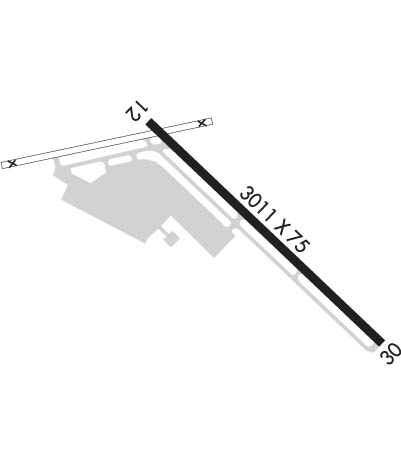
| Lat: N 4048.2 Long: W 12406.8 Elev: 11 Var: -15 Longest Runway: 3011 | ||
| CTAF: 122.7 | ||
| ||||||||||||||||||||||||||||||||||||||||||||
| ||||||||||||||||||||||||||||||||||||||||||||
| Rwy | Rwy | |||||||
| 3011x75 | 3011' | 3011x75 | 3011' | |||||
| Runway ID | Single Wheel | Double Wheel | Double Tandem Wheel | Dual Double Wheel |
| 12/30 | 19,000 | N/A | N/A | N/A |
| These numbers are Advisory and are not limits. The Airport Manager should have more accurate Weight Limits | ||||
 Airport Diagram might not be current. | |
| Facility Name: | MURRAY FLD |
| City Name: | EUREKA |
| County: | HUMBOLDT |
| State abbrev: | CA |
| State Name: | CALIFORNIA |
| Ownership: | PUBLICLY OWNED |
| Use: | OPEN TO THE PUBLIC |
| Owner's Name: | HUMBOLDT COUNTY |
| Address: | 1106 2ND ST |
| EUREKA, CA 95501 | |
| Owner's Phone: | (707) 839-5401 |
| Manager's Name: | RYAN COOLEY; AIRPORT MANAGER LOCATED AT ARCATA/EUREKA AIRPORT. |
| Address: | 3561 BOEING AVE. |
| MCKINLEYVILLE, CA 95519 | |
| Phone: | (707) 839-5402 |
| FAA Region: | WESTERN-PACIFIC |
| FAA Field Office: | SFO |
| Date | Sunrise | Sunset |
|---|---|---|
| 06/08/26 Monday | 5:45 | 20:46 |
| 06/09/26 Tuesday | 5:45 | 20:47 |
| 06/10/26 Wednesday | 5:45 | 20:47 |
| 06/11/26 Thursday | 5:44 | 20:48 |
| 06/12/26 Friday | 5:44 | 20:48 |
| 06/13/26 Saturday | 5:44 | 20:49 |
| 06/14/26 Sunday | 5:44 | 20:49 |
| 06/15/26 Monday | 5:44 | 20:50 |
| 06/16/26 Tuesday | 5:44 | 20:50 |
| 06/17/26 Wednesday | 5:44 | 20:50 |
| 06/18/26 Thursday | 5:45 | 20:51 |
| 06/19/26 Friday | 5:45 | 20:51 |
| 06/20/26 Saturday | 5:45 | 20:51 |
| 06/21/26 Sunday | 5:45 | 20:51 |
| Airport Attendance Schedule | UNATTENDED |
| Airport Status | OPERATIONAL (This Status can change at any time - please check NOTAMS) |
| Airport Lighting Schedule | ACTVT VASI RWY 30; MIRL RWY 12/30 - CTAF. |
| Airport Storage Available | Tie Downs |
| Extra Services Available | Air Freight, Charter, Flight Instruction |
| Wind Indicator | YES - (lighted) |
| Control Tower | NO |
| CTAF Frequency | 122.700 |
| Unicom Frequency | 122.700 |
| Rotating Beacon Color | WG |
| Segmented Circle | YES |
| Landing Fee | YES; LNDG FEE: CTC ARPT OR CHECK ARPT WEBSITE FOR DTLS, EXEMPTIONS. |
| Airport Inspected | STATE - performed by STATE AERONAUTICAL PERSONNEL |
| Inspection Date | 04/18/2025 |
| Type of Fuel Available | Grade 100LL |
| Airframe Repair Service | MAJOR |
| Power Plant Repair Service | MAJOR |
| Latitude | N4048.2 |
| Longitude | W12406.8 (ESTIMATED) |
| Arpt Elevation | 10ft (SURVEYED) |
| Magnetic Variation | 15E |
| 3 miles E | of EUREKA |
| Traffic Pattern Altitude | 800 |
| Sectional Chart | KLAMATH FALLS |
| Operations (Reported) | Yearly | Avg. Daily |
|---|---|---|
| General Aviation Transient | 0 | 0 |
| General Aviation Local | 0 | 0 |
| Air Taxi | 0 | 0 |
| Commerical | 0 | 0 |
| Commuter | 0 | 0 |
| Military | 0 | 0 |
| Aircraft based on Field | |
|---|---|
| General Aviation Singles | 0 |
| General Aviation Multi | 0 |
| Jet Aircraft | 0 |
| General Aviation Helicopters | 0 |
| Military Aircraft | 0 |
| Gliders | 0 |
| Ultralights | 0 |
| FSS on field | NO |
| FSS tie-in | OAKLAND |
| FSS Phone | 1-800-WX-BRIEF |
| Who issues Notams | OAK |
| Notam D service at airport | YES |
| ARTCC Name | SEATTLE |
| Airport Certification | |
| Aircraft Rescue & Firefighting Index | None |
| Airport of Entry | No |
| Custom Landing Rights | No |
| Joint Civil/Military | No |
| Military Landing rights | YES |
| NATIONAL PLAN OF INTEGRATED AIRPORT SYSTEMS (NPIAS) |
| GRANT AGREEMENTS UNDER FAAP/ADAP/AIP |
| ASSURANCES PURSUANT TO TITLE VI, CIVIL RIGHTS ACT OF 1964 |
| BE ALERT FOR BIRDS INVOF ARPT. |
| BE AWARE; CTAF FREQ SHARED WITH NEARBY ARPT. |
| FOR CD CTC SEATTLE ARTCC AT 253-351-3694. |
| DEER IN VCNTY OF RWY. |
Airport Communications & Frequencies:
| |||||||||
| Runway: 12 | Runway: 30 | ||
| Mag heading: | 120° | Mag heading: | 300° |
| Rwy Slope: | .15% Up | Rwy Slope: | -.15% Down |
| Approach: | Approach: | ||
| Pattern: | Left Traffic | Pattern: | Right Traffic |
| Markings: | NONPRECISION INSTRUMENT | Markings: | BASIC |
| Marking Condition: | GOOD | Marking Condition: | GOOD |
| Arresting Dev: | Arresting Dev: | ||
| Lat & Long: | N4048.4 W12407.0 | Lat. & Long.: | N4048.0 W12406.5 |
| Elev: | 6.2 ft. MSL | Elev: | 10.7 ft. MSL |
| TCH: | TCH: | 26 ft. AGL | |
| Visual Glide Path: | Visual Glide Path: | 4.00 degrees | |
| Displaced Threshold: | No | Displaced Threshold: | No |
| Touchdown Zone: | YES | Touchdown Zone: | YES |
| Touchdown Elev.: | 10.9 feet | Touchdown Elev.: | 10.9 feet |
| Visual Glide Slope: | Visual Glide Slope: | 2-Box VASI on LEFT side of Runway; UNUSBL BYD 6.5 NM DUE TO TRRN. | |
| RVR Equipment: | RVR Equipment: | ||
| RVV Equipment: | NO | RVV Equipment: | NO |
| Approach Lights: | Approach Lights: | ||
| REIL: | NO | REIL: | NO |
| Centerline Lights: | NO | Centerline Lights: | NO |
| Touchdown lights: | NO | Touchdown lights: | NO |
| Runway Category: | Runway with a Non-precision Approach | Runway Category: | Runway with a Visual Approach |
| Declared Distances: | Declared Distances: |
Thanks for using FltPlan.com
all rights reserved © 1999-2026 by Flight Plan LLC
