
| COUNTY MEMORIAL NEW MADRID MO |
| |
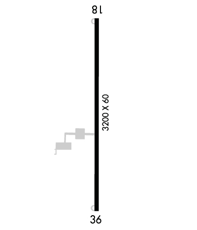
| Lat: N 3632.1 Long: W 08936.0 Elev: 296 Var: -00 Longest Runway: 3200 | ||
| CTAF: 122.8 | ||
| ||||||
|
| Rwy | Rwy | |||||||
| 3200x60 | 3200' | 3200x60 | 3200' | |||||
| Runway ID | Single Wheel | Double Wheel | Double Tandem Wheel | Dual Double Wheel |
| 18/36 | N/A | N/A | N/A | N/A |
| These numbers are Advisory and are not limits. The Airport Manager should have more accurate Weight Limits | ||||
 Airport Diagram might not be current. | |
| Facility Name: | COUNTY MEML |
| City Name: | NEW MADRID |
| County: | NEW MADRID |
| State abbrev: | MO |
| State Name: | MISSOURI |
| Ownership: | PUBLICLY OWNED |
| Use: | OPEN TO THE PUBLIC |
| Owner's Name: | COUNTY OF NEW MADRID |
| Address: | 450 MAIN STREET, PO BOX 68 |
| NEW MADRID, MO 63869 | |
| Owner's Phone: | 573-748-2524 |
| Manager's Name: | BUSTER HAMPTON; COUNTY CLERK. |
| Address: | P.O. BOX 668 |
| NEW MADRID, MO 63869 | |
| Phone: | (573) 643-2403 |
| FAA Region: | CENTRAL |
| FAA Field Office: | NONE |
| Date | Sunrise | Sunset |
|---|---|---|
| 09/24/21 Friday | 6:48 | 18:53 |
| 09/25/21 Saturday | 6:48 | 18:51 |
| 09/26/21 Sunday | 6:49 | 18:50 |
| 09/27/21 Monday | 6:50 | 18:48 |
| 09/28/21 Tuesday | 6:51 | 18:47 |
| 09/29/21 Wednesday | 6:52 | 18:45 |
| 09/30/21 Thursday | 6:53 | 18:44 |
| 10/01/21 Friday | 6:53 | 18:42 |
| 10/02/21 Saturday | 6:54 | 18:41 |
| 10/03/21 Sunday | 6:55 | 18:39 |
| 10/04/21 Monday | 6:56 | 18:38 |
| 10/05/21 Tuesday | 6:57 | 18:36 |
| 10/06/21 Wednesday | 6:58 | 18:35 |
| 10/07/21 Thursday | 6:58 | 18:33 |
| Airport Attendance Schedule | OCT-MAR MON-FRI 0800-1630, APR-SEP MON-FRI 0800-1730, SAT-SUN 0900-1630 |
| Airport Status | OPERATIONAL (This Status can change at any time - please check NOTAMS) |
| Airport Lighting Schedule | MIRL RWY 18/36 PRESET ON MED INTST; TO INCR INTST & ACTVT MIRL RWY 18/36 - CTAF. |
| Airport Storage Available | Tie Downs, Hanger |
| Extra Services Available | Crop Dusting |
| Wind Indicator | YES - (lighted) |
| Control Tower | NO |
| CTAF Frequency | 122.800 |
| Unicom Frequency | 122.800; UNICOM UNMON. |
| Rotating Beacon Color | CLEAR-GREEN (Light Land Airport) |
| Segmented Circle | YES |
| Landing Fee | NO |
| Airport Inspected | STATE - performed by STATE AERONAUTICAL PERSONNEL |
| Inspection Date | 07/24/2019 |
| Type of Fuel Available | Grade 100LL; -10FOR SVC AFT HRS, CALL ARPT MGR AT (573) 643-2403 OR (573) 934-3734. |
| Airframe Repair Service | None |
| Power Plant Repair Service | NONE |
| Latitude | N3632.1 |
| Longitude | W08936.0 (ESTIMATED) |
| Arpt Elevation | 295ft (SURVEYED) |
| Magnetic Variation | 00E |
| 4 miles SW | of NEW MADRID |
| Traffic Pattern Altitude | |
| Sectional Chart | ST LOUIS |
| Operations (Reported) | Yearly | Avg. Daily |
|---|---|---|
| General Aviation Transient | 3800 | 10 |
| General Aviation Local | 12250 | 34 |
| Air Taxi | 900 | 2 |
| Commerical | 0 | 0 |
| Commuter | 0 | 0 |
| Military | 50 | 0 |
| Aircraft based on Field | |
|---|---|
| General Aviation Singles | 7 |
| General Aviation Multi | 1 |
| Jet Aircraft | 0 |
| General Aviation Helicopters | 1 |
| Military Aircraft | 0 |
| Gliders | 0 |
| Ultralights | 0 |
| FSS on field | NO |
| FSS tie-in | SAINT LOUIS |
| FSS Phone | 1-800-WX-BRIEF |
| Who issues Notams | STL |
| Notam D service at airport | YES |
| ARTCC Name | MEMPHIS |
| Airport Certification | |
| Aircraft Rescue & Firefighting Index | None |
| Airport of Entry | No |
| Custom Landing Rights | No |
| Joint Civil/Military | No |
| Military Landing rights | YES |
| NATIONAL PLAN OF INTEGRATED AIRPORT SYSTEMS (NPIAS) |
| ASSURANCES PURSUANT TO TITLE VI, CIVIL RIGHTS ACT OF 1964 |
| GRANT AGREEMENT HAS EXPIRED; HOWEVER, AGREEMENT REMAINS IN EFFECT FOR THIS FACILITY AS LONG AS IT IS PUBLIC USE. |
| CROP DUSTING ACFT ON & INVOF ARPT. |
| WATERFOWL INVOF ARPT. |
| FOR CD CTC MEMPHIS ARTCC AT 901-368-8453/8449. |
Airport Communications & Frequencies:
| |||||||||
| Runway: 18 | Runway: 36 | ||
| Mag heading: | 180° | Mag heading: | 360° |
| Rwy Slope: | .03% Up | Rwy Slope: | -.03% Down |
| Approach: | Approach: | ||
| Pattern: | Left Traffic | Pattern: | Left Traffic |
| Markings: | NONPRECISION INSTRUMENT | Markings: | NONPRECISION INSTRUMENT |
| Marking Condition: | GOOD | Marking Condition: | GOOD |
| Arresting Dev: | Arresting Dev: | ||
| Lat & Long: | N3632.4 W08936.0 | Lat. & Long.: | N3631.9 W08936.0 |
| Elev: | 294.8 ft. MSL | Elev: | 295.8 ft. MSL |
| TCH: | TCH: | ||
| Visual Glide Path: | Visual Glide Path: | ||
| Displaced Threshold: | No | Displaced Threshold: | No |
| Touchdown Zone: | YES | Touchdown Zone: | YES |
| Touchdown Elev.: | 295.0 feet | Touchdown Elev.: | 295.8 feet |
| Visual Glide Slope: | Visual Glide Slope: | ||
| RVR Equipment: | RVR Equipment: | ||
| RVV Equipment: | NO | RVV Equipment: | NO |
| Approach Lights: | Approach Lights: | ||
| REIL: | NO | REIL: | NO |
| Centerline Lights: | NO | Centerline Lights: | NO |
| Touchdown lights: | NO | Touchdown lights: | NO |
| Runway Category: | Runway with a Non-precision Approach | Runway Category: | Runway with a Non-precision Approach |
| Declared Distances: | Declared Distances: | ||
| Obstructions: | ROAD | Obstructions: | |
| Marked: | NOT Marked/Lighted | Marked: | |
| Clearance slope: | 6:1 | Clearance slope: | 20:1 |
| Obstruction height: | 15 feet AGL | Obstruction height: | |
| Dist. from runway: | 300 feet | Dist. from runway: | |
| Centerline offset: | 250 right of centerline | Centerline offset: | |
| Comments: | Comments: |
Thanks for using FltPlan.com
all rights reserved © 1999-2021 by Flight Plan LLC
