
| ERIE MUNI ERIE CO |
| |
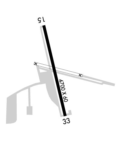
| Lat: N 4000.6 Long: W 10502.9 Elev: 5119 Var: -08 Longest Runway: 4700 | ||
| AWOS: 133.82 CTAF: 123.0 | ||
| ||||||||||||||||||||||||||||||||||||||||||||
| ||||||||||||||||||||||||||||||||||||||||||||
| ||||||||||||||||||||||||||||||||||||||||||||
| Rwy | Rwy | |||||||
| 4700x60 | 4700' | 4700x60 | 4700' | |||||
| Runway ID | Single Wheel | Double Wheel | Double Tandem Wheel | Dual Double Wheel |
| 16/34 | 12,500 | N/A | N/A | N/A |
| These numbers are Advisory and are not limits. The Airport Manager should have more accurate Weight Limits | ||||
 Airport Diagram might not be current. | |
| Facility Name: | ERIE MUNI |
| City Name: | ERIE |
| County: | WELD |
| State abbrev: | CO |
| State Name: | COLORADO |
| Ownership: | PUBLICLY OWNED |
| Use: | OPEN TO THE PUBLIC |
| Owner's Name: | TOWN OF ERIE |
| Address: | PO BOX 750 |
| ERIE, CO 80516 | |
| Owner's Phone: | 303-926-2870 |
| Manager's Name: | JASON HURD |
| Address: | 395 AIRPORT DRIVE |
| ERIE, CO 80516 | |
| Phone: | 303-664-0633 |
| FAA Region: | NORTHWEST MOUNTAIN |
| FAA Field Office: | DEN |
| Date | Sunrise | Sunset |
|---|---|---|
| 06/08/26 Monday | 5:31 | 20:27 |
| 06/09/26 Tuesday | 5:31 | 20:28 |
| 06/10/26 Wednesday | 5:31 | 20:28 |
| 06/11/26 Thursday | 5:31 | 20:29 |
| 06/12/26 Friday | 5:31 | 20:29 |
| 06/13/26 Saturday | 5:31 | 20:30 |
| 06/14/26 Sunday | 5:31 | 20:30 |
| 06/15/26 Monday | 5:31 | 20:31 |
| 06/16/26 Tuesday | 5:31 | 20:31 |
| 06/17/26 Wednesday | 5:31 | 20:31 |
| 06/18/26 Thursday | 5:31 | 20:32 |
| 06/19/26 Friday | 5:31 | 20:32 |
| 06/20/26 Saturday | 5:31 | 20:32 |
| 06/21/26 Sunday | 5:31 | 20:32 |
| Airport Attendance Schedule | MON-SAT 0800-1700, SUN 0800-1400 |
| Airport Status | OPERATIONAL (This Status can change at any time - please check NOTAMS) |
| Airport Lighting Schedule | ACTVT REIL RWY 16; PAPI RWY 16 & 34; MIRL RWY 16/34 - CTAF. |
| Airport Storage Available | Tie Downs, Hanger |
| Extra Services Available | Flight Instruction, Aircraft Rental, Aircraft Sales |
| Wind Indicator | YES - (lighted) |
| Control Tower | NO |
| CTAF Frequency | 123.000 |
| Unicom Frequency | 123.000 |
| Rotating Beacon Color | WG |
| Segmented Circle | YES |
| Landing Fee | NO |
| Airport Inspected | STATE - performed by STATE AERONAUTICAL PERSONNEL |
| Inspection Date | 04/22/2025 |
| Type of Fuel Available | Grade 100LL, JET A (freeze point -40C); -10SELF SVC AVBL H24 WITH CREDIT CARD. |
| Airframe Repair Service | MAJOR |
| Power Plant Repair Service | MAJOR |
| Latitude | N4000.6 |
| Longitude | W10502.9 (ESTIMATED) |
| Arpt Elevation | 5119ft (SURVEYED) |
| Magnetic Variation | 08E |
| 3 miles S | of ERIE |
| Traffic Pattern Altitude | |
| Sectional Chart | CHEYENNE |
| Operations (Reported) | Yearly | Avg. Daily |
|---|---|---|
| General Aviation Transient | 0 | 0 |
| General Aviation Local | 0 | 0 |
| Air Taxi | 0 | 0 |
| Commerical | 0 | 0 |
| Commuter | 0 | 0 |
| Military | 0 | 0 |
| Aircraft based on Field | |
|---|---|
| General Aviation Singles | 0 |
| General Aviation Multi | 0 |
| Jet Aircraft | 0 |
| General Aviation Helicopters | 0 |
| Military Aircraft | 0 |
| Gliders | 0 |
| Ultralights | 0 |
| FSS on field | NO |
| FSS tie-in | DENVER |
| FSS Phone | 1-800-WX-BRIEF |
| Who issues Notams | DEN |
| Notam D service at airport | YES |
| ARTCC Name | DENVER |
| Airport Certification | |
| Aircraft Rescue & Firefighting Index | None |
| Airport of Entry | No |
| Custom Landing Rights | No |
| Joint Civil/Military | No |
| Military Landing rights | No |
| NATIONAL PLAN OF INTEGRATED AIRPORT SYSTEMS (NPIAS) |
| AFT HR EMERG - 303-870-5659. |
| TWY A LGTD. |
| FOR CD CTC DENVER APCH AT 303-342-1916. |
| RWY 16/3 4 -2 FT TRRN 60 - 70 FT E OF CNTRLN FULL LEN. |
| RWY 16 -2 TO -6 FT DITCH WI 700 FT OF RWY END VARIOUS LOCATIONS. |
| RWY 34 30 FT ROAD 1350 FT FM THR BOTH SIDES; -6 TO -12 FT DITCH 60 FT L OF CNTRLN PARL TO FIRST 750 FT OF RWY. |
Airport Communications & Frequencies:
| ||||||||||||||
| Runway: 16 | Runway: 34 | ||
| Mag heading: | 159° | Mag heading: | 339° |
| Rwy Slope: | .93% Up | Rwy Slope: | -.93% Down |
| Approach: | Approach: | ||
| Pattern: | Right Traffic | Pattern: | Left Traffic |
| Markings: | NONPRECISION INSTRUMENT | Markings: | NONPRECISION INSTRUMENT |
| Marking Condition: | GOOD | Marking Condition: | GOOD |
| Arresting Dev: | Arresting Dev: | ||
| Lat & Long: | N4001.0 W10503.0 | Lat. & Long.: | N4000.2 W10502.8 |
| Elev: | 5075.5 ft. MSL | Elev: | 5119.4 ft. MSL |
| TCH: | 58 ft. AGL | TCH: | 52 ft. AGL |
| Visual Glide Path: | 3.00 degrees | Visual Glide Path: | 3.00 degrees |
| Displaced Threshold: | No | Displaced Threshold: | No |
| Touchdown Zone: | YES | Touchdown Zone: | YES |
| Touchdown Elev.: | 5098.1 feet | Touchdown Elev.: | 5119.4 feet |
| Visual Glide Slope: | 2-Light PAPI on LEFT side of Runway | Visual Glide Slope: | 2-Light PAPI on LEFT side of Runway |
| RVR Equipment: | RVR Equipment: | ||
| RVV Equipment: | NO | RVV Equipment: | NO |
| Approach Lights: | Approach Lights: | ||
| REIL: | YES | REIL: | NO |
| Centerline Lights: | NO | Centerline Lights: | NO |
| Touchdown lights: | NO | Touchdown lights: | NO |
| Runway Category: | Runway with a Non-precision Approach | Runway Category: | Runway with a Non-precision Approach |
| Declared Distances: | Declared Distances: | ||
| Obstructions: | Obstructions: | TREE | |
| Marked: | Marked: | NOT Marked/Lighted | |
| Clearance slope: | 20:1 | Clearance slope: | 16:1 |
| Obstruction height: | Obstruction height: | 78 feet AGL | |
| Dist. from runway: | Dist. from runway: | 1522 feet | |
| Centerline offset: | Centerline offset: | 422 feet left of centerline | |
| Comments: | Comments: |
Thanks for using FltPlan.com
all rights reserved © 1999-2026 by Flight Plan LLC
