
| ELLINGTON FIELD HOUSTON TX |
| |
| Lat: N 2936.4 Long: W 09509.5 Elev: 33 Var: -05 Longest Runway: 9001 | ||
| Dept. ATIS: 135.57 Arr. ATIS: 135.57 Ground: 121.6 Tower: 126.05 | ||
| ||||||||||||||||||||||||||||||||||||||||||||||||||||||||||||||||||||
| ||||||||||||||||||||||||||||||||||||||||||||||||||||||||||||||||||||
| ||||||||||||||||||||||||||||||||||||||||||||||||||||||||||||||||||||
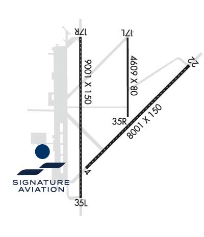
| Rwy | Rwy | |||||||
| 8001x150 | 8001' | 8001x150 | 8001' | 110.10 - 219° | ||||
| 4609x75 | 4609' | 4609x75 | 4609' | |||||
| 9001x150 | 9001' | 110.30 - 174° | 9001x150 | 9001' | 111.10 - 354° | |||
| Runway ID | Single Wheel | Double Wheel | Double Tandem Wheel | Dual Double Wheel |
| 04/22 | 100,000 | 164,000 | 300,000 | 668,000 |
| 17L/35R | 24,000 | 63,000 | 145,000 | 300,000 |
| 17R/35L | 100,000 | 190,000 | 590,000 | 800,000 |
| These numbers are Advisory and are not limits. The Airport Manager should have more accurate Weight Limits | ||||
 Airport Diagram might not be current. | |
| Facility Name: | ELLINGTON |
| City Name: | HOUSTON |
| County: | HARRIS |
| State abbrev: | TX |
| State Name: | TEXAS |
| Ownership: | PUBLICLY OWNED |
| Use: | OPEN TO THE PUBLIC |
| Owner's Name: | CITY OF HOUSTON |
| Address: | 16930 JFK BLVD |
| HOUSTON, TX 77032 | |
| Owner's Phone: | 281-233-3000 |
| Manager's Name: | ARTURO MACHUCA |
| Address: | BLDG 510 ELLINGTON FIELD |
| HOUSTON, TX 77034 | |
| Phone: | 713-847-4200 |
| FAA Region: | SOUTHWEST |
| FAA Field Office: | TEX |

| Date | Sunrise | Sunset |
|---|---|---|
| 09/24/21 Friday | 7:10 | 19:15 |
| 09/25/21 Saturday | 7:10 | 19:14 |
| 09/26/21 Sunday | 7:11 | 19:12 |
| 09/27/21 Monday | 7:12 | 19:11 |
| 09/28/21 Tuesday | 7:12 | 19:10 |
| 09/29/21 Wednesday | 7:13 | 19:09 |
| 09/30/21 Thursday | 7:13 | 19:08 |
| 10/01/21 Friday | 7:14 | 19:06 |
| 10/02/21 Saturday | 7:14 | 19:05 |
| 10/03/21 Sunday | 7:15 | 19:04 |
| 10/04/21 Monday | 7:15 | 19:03 |
| 10/05/21 Tuesday | 7:16 | 19:02 |
| 10/06/21 Wednesday | 7:17 | 19:00 |
| 10/07/21 Thursday | 7:17 | 18:59 |
| Airport Attendance Schedule | CONTINUOUS |
| Airport Status | OPERATIONAL (This Status can change at any time - please check NOTAMS) |
| Airport Lighting Schedule | SS-SR |
| Airport Storage Available | Tie Downs |
| Extra Services Available | Cargo Handling, Flight Instruction, Aircraft Rental |
| Wind Indicator | YES - (lighted) |
| Control Tower | YES |
| CTAF Frequency | |
| Unicom Frequency | 122.950 |
| Rotating Beacon Color | CLEAR-GREEN (Light Land Airport) |
| Segmented Circle | NO |
| Landing Fee |
| Airport Inspected | FEDERAL - performed by FAA AIRPORTS FIELD PERSONNEL |
| Inspection Date | 06/01/2017 |
| Type of Fuel Available | Grade 100LL, JET A (freeze point -40C) |
| Airframe Repair Service | MAJOR |
| Power Plant Repair Service | MAJOR |
| Latitude | N2936.4 |
| Longitude | W09509.5 (ESTIMATED) |
| Arpt Elevation | 32ft (SURVEYED) |
| Magnetic Variation | 05E |
| 15 miles SE | of HOUSTON |
| Traffic Pattern Altitude | 600; TPA: 1067 FT AGL VFR RECTANGULAR, 1567 FT AGL OVERHEAD, 567 FT AGL LGT ACFT. |
| Sectional Chart | HOUSTON |
| Operations (Reported) | Yearly | Avg. Daily |
|---|---|---|
| General Aviation Transient | 33197 | 91 |
| General Aviation Local | 17876 | 49 |
| Air Taxi | 10718 | 29 |
| Commerical | 2514 | 7 |
| Commuter | 0 | 0 |
| Military | 23180 | 64 |
| Aircraft based on Field | |
|---|---|
| General Aviation Singles | 32 |
| General Aviation Multi | 8 |
| Jet Aircraft | 30 |
| General Aviation Helicopters | 0 |
| Military Aircraft | 25 |
| Gliders | 0 |
| Ultralights | 0 |
| FSS on field | NO |
| FSS tie-in | FORT WORTH |
| FSS Phone | 1-800-WX-BRIEF |
| Who issues Notams | EFD |
| Notam D service at airport | YES |
| ARTCC Name | HOUSTON |
| Airport Certification | |
| Aircraft Rescue & Firefighting Index | AIRPORT HAS A CERTIFICATE UNDER CFR PART 139 |
| Airport of Entry | No |
| Custom Landing Rights | No |
| Joint Civil/Military | No |
| Military Landing rights | YES |
| NATIONAL PLAN OF INTEGRATED AIRPORT SYSTEMS (NPIAS) |
| GRANT AGREEMENTS UNDER FAAP/ADAP/AIP |
| SURPLUS PROPERTY AGREEMENT UNDER PUBLIC LAW 289 |
| ASSURANCES PURSUANT TO TITLE VI, CIVIL RIGHTS ACT OF 1964 |
| TWY B UNLGTD EAST OF RY 17R/35L; DALGT USE ONLY. |
| NMRS BIRDS ON AND INVOF ARPT ALL QUADRANTS. |
| RWY 17R ARRESTING BARRIERS 1500 FT LCTD IN SAFETY AREA 14 INCH LIP EACH SIDE OF RWY. |
| RWY 35L ARRESTING BARRIERS 1849 FT LCTD IN SAFETY AREA 14 INCH LIP EACH SIDE OF RWY. |
| FLUID: LHOX HPOX |
| SEE FLIP AP/1 SUPPLEMENTARY ARPT |
| CAUTION: NMRS SMALL ARPT WITH EXTV TRNG IN AREA OF ARPT. |
| NS ABTMT: NOISE SENSITIVE AREAS S AND E OF FLD. JET ACFT RSTD TO STR-IN FULL STOP LDG ONLY BTN 2200-0700 DLY, 2200-1300 SUN. NO MULTI PRACTICE VFR APCH BTN 2300-0700 SUN. ON DEP JET ACFT MIN USE OF AFTER BURNERS AND CLIMB RWY HDG TO 1000' PRIOR TO TURNS OR REJOIN. |
| CG: MIN 24 HR PPR EXC CG MSN. C713-578-3000. |
| STREET LGTS LCTD 700 FT EAST OF RWY 17R APCH MAY BE MISTAKEN FOR APCH LGTS. |
| BE ALERT FOR MIL ACFT AT 1600 MSL MAKING OVHD APCHS. |
| MISC: PRK RAMP CAP TDT710. |
| ANG: ANG RAMP CLSD TO ALL ACFT EXEC OFFL BUS ONLY. 24 HRS PPR, CTC BASE OPS, 1200-2130Z++ TUE-FRI, CLSD WKEND & HOL. DSN 454-2142, C281-929-2142. COMD POST AVBL 24 HR, DSN 454-2716, C281-929-2716. ALL OTHER TRAN ACFT CTC FBO 281-484-6551. |
| RWY 04 ARRESTING BARRIERS 1563 FT LCTD IN SAFETY AREA 14 INCH LIP EACH SIDE OF RWY. |
| RWY 22 ARRESTING BARRIERS 1496 FT LCTD IN SAFETY AREA 14 INCH LIP EACH SIDE OF RWY. |
| SERVICE - AGEAR: POTENTIAL FOR TAIL HOOK SKIP ON RWY 17R/35L AND RWY 04/22 DUE TO CNTLN LGT WITHIN 200' OF RWY A-G. AGEAR: A-GEAR LGTD MRK PLACEMENT EXCEEDS 75' FR RWY EDGE. |
| ARPT CLSD TO ACFT WITH WINGSPAN 171 FT OR GREATER EXCEPT 24 HRS PPR 281-433-1612. |
| SERVICE-FUEL: A++ (MIL). |
| ANG OPS COMD POST 288.5. |
| ANG: BASH PHASE II COND JUN-SEP FOR MIGRATORY BIRDS. BASH PHASE I OCT-MAY. |
| JASU: 1(-95) 1(-86) 1(JETEX5). |
| UAS OPS WI ELLINGTON CLASS D ASP, OPR HRS VARY. |
| PPR FOR UNSCHEDULED AIR CARRIER OPS, CTC 281-433-1612. |
| RWY 17L-35R AND TWY B EAST OF RWY 17R-35L NOT AVBL FOR AIR CARRIER ACFT. |
| NSTD AFLD MRK ON ANG ACFT PRK APN. |
| 70 FT AGL TANKS LCTD 1400 FT NE OF RY 17R APCH. |
| RWY 17L/35R BTWN TWYS C & G - DUAL PURPOSE RWY/TWY WITH TWY LGTS. |
Airport Communications & Frequencies:
| |||||||||||||||||||||||||||||||
| Runway: 04 | Runway: 22 | ||
| Mag heading: | 39° | Mag heading: | 219° |
| Rwy Slope: | .05% Up | Rwy Slope: | -.05% Down |
| Approach: | Approach: | ILS | |
| Pattern: | Right Traffic | Pattern: | Left Traffic |
| Markings: | NONPRECISION INSTRUMENT | Markings: | PRECISION INSTRUMENT |
| Marking Condition: | GOOD | Marking Condition: | GOOD |
| Arresting Dev: | BAK-12,BAK-14; BAK-14 BAK-12B(B) (1563'). | Arresting Dev: | BAK-12,BAK-14; BAK-14 BAK-12B(B) (1496'). |
| Lat & Long: | N2935.9 W09509.8 | Lat. & Long.: | N2936.8 W09508.7 |
| Elev: | 26.0 ft. MSL | Elev: | 30.3 ft. MSL |
| TCH: | 50 ft. AGL | TCH: | 50 ft. AGL |
| Visual Glide Path: | 3.00 degrees | Visual Glide Path: | 3.00 degrees |
| Displaced Threshold: | No | Displaced Threshold: | No |
| Touchdown Zone: | YES | Touchdown Zone: | YES |
| Touchdown Elev.: | 30.3 feet | Touchdown Elev.: | 30.6 feet |
| Visual Glide Slope: | 4-Light PAPI on LEFT side of Runway | Visual Glide Slope: | 4-Light PAPI on LEFT side of Runway |
| RVR Equipment: | TOUCHDOWN-ROLLOUT | RVR Equipment: | TOUCHDOWN-ROLLOUT |
| RVV Equipment: | NO | RVV Equipment: | NO |
| Approach Lights: | Approach Lights: | MALSR - 1,400 foot medium intensity approach lighting system with runway alignment indicator lights | |
| REIL: | NO | REIL: | NO |
| Centerline Lights: | YES | Centerline Lights: | YES |
| Touchdown lights: | NO | Touchdown lights: | YES |
| Runway Category: | Runway with a Non-precision Approach having visibility minimums greater than 3/4 mile | Runway Category: | Precision Instrument Runway |
| Declared Distances: | TORA:8001' TODA:8001' ASDA:8001' LDA:8001' | Declared Distances: | TORA:8001' TODA:8001' ASDA:8001' LDA:8001' |
| Runway: 17L | Runway: 35R | ||
| Mag heading: | 174° | Mag heading: | 354° |
| Rwy Slope: | -.02% Down | Rwy Slope: | .02% Up |
| Approach: | Approach: | ||
| Pattern: | Left Traffic | Pattern: | Right Traffic |
| Markings: | BASIC | Markings: | BASIC |
| Marking Condition: | GOOD | Marking Condition: | GOOD |
| Arresting Dev: | Arresting Dev: | ||
| Lat & Long: | N2937.1 W09509.4 | Lat. & Long.: | N2936.3 W09509.4 |
| Elev: | 31.0 ft. MSL | Elev: | 30.1 ft. MSL |
| TCH: | TCH: | ||
| Visual Glide Path: | Visual Glide Path: | ||
| Displaced Threshold: | No | Displaced Threshold: | No |
| Touchdown Zone: | YES | Touchdown Zone: | YES |
| Touchdown Elev.: | 32.5 feet | Touchdown Elev.: | 32.0 feet |
| Visual Glide Slope: | Visual Glide Slope: | ||
| RVR Equipment: | RVR Equipment: | ||
| RVV Equipment: | NO | RVV Equipment: | NO |
| Approach Lights: | Approach Lights: | ||
| REIL: | NO | REIL: | NO |
| Centerline Lights: | NO | Centerline Lights: | NO |
| Touchdown lights: | NO | Touchdown lights: | NO |
| Runway Category: | Runway with a Visual Approach | Runway Category: | Runway with a Visual Approach |
| Declared Distances: | TORA:4609' TODA:4609' ASDA:4609' LDA:4609' | Declared Distances: | TORA:4609' TODA:4609' ASDA:4609' LDA:4609' |
| Runway: 17R | Runway: 35L | ||
| Mag heading: | 174° | Mag heading: | 354° |
| Rwy Slope: | -.05% Down | Rwy Slope: | .05% Up |
| Approach: | LOC/GS | Approach: | ILS |
| Pattern: | Left Traffic | Pattern: | Right Traffic |
| Markings: | PRECISION INSTRUMENT | Markings: | PRECISION INSTRUMENT |
| Marking Condition: | GOOD | Marking Condition: | GOOD |
| Arresting Dev: | BAK-12,BAK-14; BAK-14 BAK-12B(B) (1500'). | Arresting Dev: | BAK-12,BAK-14; BAK-14 BAK-12B(B) (1850'). |
| Lat & Long: | N2937.1 W09509.9 | Lat. & Long.: | N2935.6 W09509.8 |
| Elev: | 31.9 ft. MSL | Elev: | 27.5 ft. MSL |
| TCH: | 48 ft. AGL | TCH: | 32 ft. AGL |
| Visual Glide Path: | 3.00 degrees | Visual Glide Path: | 3.00 degrees |
| Displaced Threshold: | No | Displaced Threshold: | No |
| Touchdown Zone: | YES | Touchdown Zone: | YES |
| Touchdown Elev.: | 32.0 feet | Touchdown Elev.: | 27.6 feet |
| Visual Glide Slope: | 4-Light PAPI on LEFT side of Runway | Visual Glide Slope: | 4-Light PAPI on LEFT side of Runway |
| RVR Equipment: | TOUCHDOWN-ROLLOUT | RVR Equipment: | TOUCHDOWN-ROLLOUT |
| RVV Equipment: | NO | RVV Equipment: | NO |
| Approach Lights: | MALSF - 1,400 foot medium intensity approach lighting system with sequenced flashers | Approach Lights: | MALSF - 1,400 foot medium intensity approach lighting system with sequenced flashers |
| REIL: | NO | REIL: | NO |
| Centerline Lights: | YES | Centerline Lights: | YES |
| Touchdown lights: | YES | Touchdown lights: | YES |
| Runway Category: | Precision Instrument Runway | Runway Category: | Precision Instrument Runway |
| Declared Distances: | TORA:9001' TODA:9001' ASDA:9001' LDA:9001' | Declared Distances: | TORA:9001' TODA:9001' ASDA:9001' LDA:9001' |
Thanks for using FltPlan.com
all rights reserved © 1999-2021 by Flight Plan LLC


