
| NEEDLES NEEDLES CA |
| |
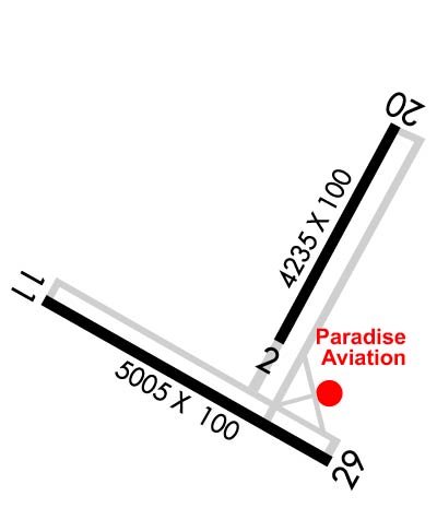
| Lat: N 3446.0 Long: W 11437.4 Elev: 983 Var: -14 Longest Runway: 5005 | ||
| AWOS: 128.32 CTAF: 123.0 | ||
| ||||||||||||||||||||||||||||||||||||||||||||
| ||||||||||||||||||||||||||||||||||||||||||||
| ||||||||||||||||||||||||||||||||||||||||||||
| Rwy | Rwy | |||||||
| 4235x100 | 4235' | 4235x100 | 4235' | |||||
| 5005x100 | 5005' | 5005x100 | 5005' | |||||
| Runway ID | Single Wheel | Double Wheel | Double Tandem Wheel | Dual Double Wheel |
| 02/20 | 16,000 | 32,000 | N/A | N/A |
| 11/29 | 16,000 | 32,000 | N/A | N/A |
| These numbers are Advisory and are not limits. The Airport Manager should have more accurate Weight Limits | ||||
 Airport Diagram might not be current. | |
| Facility Name: | NEEDLES |
| City Name: | NEEDLES |
| County: | SAN BERNARDINO |
| State abbrev: | CA |
| State Name: | CALIFORNIA |
| Ownership: | PUBLICLY OWNED |
| Use: | OPEN TO THE PUBLIC |
| Owner's Name: | CO OF SAN BERNARDINO |
| Address: | 268 HOSPITALITY LANE, SUITE 302 |
| SAN BERNARDINO, CA 92415 | |
| Owner's Phone: | 909-387-7810 |
| Manager's Name: | TESS COOK |
| Address: | 711 AIRPORT RD |
| NEEDLES, CA 92363 | |
| Phone: | 909-327-8740 |
| FAA Region: | WESTERN-PACIFIC |
| FAA Field Office: | LAX |
| Date | Sunrise | Sunset |
|---|---|---|
| 06/08/26 Monday | 5:25 | 19:50 |
| 06/09/26 Tuesday | 5:25 | 19:51 |
| 06/10/26 Wednesday | 5:25 | 19:51 |
| 06/11/26 Thursday | 5:25 | 19:52 |
| 06/12/26 Friday | 5:25 | 19:52 |
| 06/13/26 Saturday | 5:25 | 19:53 |
| 06/14/26 Sunday | 5:25 | 19:53 |
| 06/15/26 Monday | 5:25 | 19:53 |
| 06/16/26 Tuesday | 5:25 | 19:54 |
| 06/17/26 Wednesday | 5:25 | 19:54 |
| 06/18/26 Thursday | 5:25 | 19:54 |
| 06/19/26 Friday | 5:25 | 19:55 |
| 06/20/26 Saturday | 5:25 | 19:55 |
| 06/21/26 Sunday | 5:25 | 19:55 |
| Airport Attendance Schedule | UNATTENDED |
| Airport Status | OPERATIONAL (This Status can change at any time - please check NOTAMS) |
| Airport Lighting Schedule | ACTVT MIRL RY 11/29 & RY 02/20, REIL RY 11& RY 29 - CTAF. PAPI RY 11, RY 29, RY 02 & RY 20 OPER CONTINUOUSLY. |
| Airport Storage Available | Tie Downs |
| Extra Services Available | NONE |
| Wind Indicator | YES - (lighted) |
| Control Tower | NO |
| CTAF Frequency | 123.000 |
| Unicom Frequency | 123.000 |
| Rotating Beacon Color | WG |
| Segmented Circle | YES |
| Landing Fee | NO |
| Airport Inspected | STATE - performed by STATE AERONAUTICAL PERSONNEL |
| Inspection Date | 07/16/2025 |
| Type of Fuel Available | Grade 100LL, JET A (freeze point -40C); -A JET A FUEL AVBL 24 HRS SELF SVC; -10100LL FUEL AVBL 24 HRS SELF SRV |
| Airframe Repair Service | MINOR |
| Power Plant Repair Service | MINOR |
| Latitude | N3446.0 |
| Longitude | W11437.4 (ESTIMATED) |
| Arpt Elevation | 983ft (SURVEYED) |
| Magnetic Variation | 14E |
| 5 miles S | of NEEDLES |
| Traffic Pattern Altitude | |
| Sectional Chart | PHOENIX |
| Operations (Reported) | Yearly | Avg. Daily |
|---|---|---|
| General Aviation Transient | 0 | 0 |
| General Aviation Local | 0 | 0 |
| Air Taxi | 0 | 0 |
| Commerical | 0 | 0 |
| Commuter | 0 | 0 |
| Military | 0 | 0 |
| Aircraft based on Field | |
|---|---|
| General Aviation Singles | 0 |
| General Aviation Multi | 0 |
| Jet Aircraft | 0 |
| General Aviation Helicopters | 0 |
| Military Aircraft | 0 |
| Gliders | 0 |
| Ultralights | 0 |
| FSS on field | NO |
| FSS tie-in | RIVERSIDE |
| FSS Phone | 1-800-WX-BRIEF |
| Who issues Notams | EED |
| Notam D service at airport | YES |
| ARTCC Name | LOS ANGELES |
| Airport Certification | |
| Aircraft Rescue & Firefighting Index | None |
| Airport of Entry | No |
| Custom Landing Rights | No |
| Joint Civil/Military | No |
| Military Landing rights | YES |
| NATIONAL PLAN OF INTEGRATED AIRPORT SYSTEMS (NPIAS) |
| GRANT AGREEMENTS UNDER FAAP/ADAP/AIP |
| CONVEYANCE UNDER SCETION 16, FEDERAL AIRPORT ACT OF 1946 OR SECTION 23, AIRPORT AND AIRWAY DEVELOPMENT ACT OF 1970 |
| ASSURANCES PURSUANT TO TITLE VI, CIVIL RIGHTS ACT OF 1964 |
| AGREEMENT UNDER DLAND OR DCLA HAS EXPIRED. |
| (E81) 2 LGTS EACH SIDE MARKING RWY EXITS; REFLECTORS MARKING TWYS. |
| FOR CD IF UNA TO CTC ON FSS FREQ, CTC LOS ANGELES ARTCC AT 661-575-2079. |
| RWY 02/2 0 CRACKS IN PAVEMENT. |
| RWY 11/2 9 CRACKS IN PAVEMENT |
Airport Communications & Frequencies:
| |||||||||
| Runway: 02 | Runway: 20 | ||
| Mag heading: | 15° | Mag heading: | 195° |
| Rwy Slope: | -2.02% Down | Rwy Slope: | 2.02% Up |
| Approach: | Approach: | ||
| Pattern: | Left Traffic | Pattern: | Left Traffic |
| Markings: | NONPRECISION INSTRUMENT | Markings: | NONPRECISION INSTRUMENT |
| Marking Condition: | FAIR | Marking Condition: | FAIR |
| Arresting Dev: | Arresting Dev: | ||
| Lat & Long: | N3445.9 W11437.4 | Lat. & Long.: | N3446.5 W11437.0 |
| Elev: | 929.4 ft. MSL | Elev: | 843.9 ft. MSL |
| TCH: | 30 ft. AGL | TCH: | 40 ft. AGL |
| Visual Glide Path: | 3.00 degrees | Visual Glide Path: | 3.00 degrees |
| Displaced Threshold: | No | Displaced Threshold: | No |
| Touchdown Zone: | YES | Touchdown Zone: | YES |
| Touchdown Elev.: | 938.6 feet | Touchdown Elev.: | 902.8 feet |
| Visual Glide Slope: | 2-Light PAPI on LEFT side of Runway | Visual Glide Slope: | 2-Light PAPI on LEFT side of Runway |
| RVR Equipment: | RVR Equipment: | ||
| RVV Equipment: | NO | RVV Equipment: | NO |
| Approach Lights: | Approach Lights: | ||
| REIL: | NO | REIL: | NO |
| Centerline Lights: | NO | Centerline Lights: | NO |
| Touchdown lights: | NO | Touchdown lights: | NO |
| Runway Category: | Runway with a Visual Approach | Runway Category: | Runway with a Visual Approach |
| Declared Distances: | Declared Distances: |
| Runway: 11 | Runway: 29 | ||
| Mag heading: | 105° | Mag heading: | 285° |
| Rwy Slope: | -1.29% Down | Rwy Slope: | 1.29% Up |
| Approach: | Approach: | ||
| Pattern: | Left Traffic | Pattern: | Left Traffic |
| Markings: | BASIC | Markings: | BASIC |
| Marking Condition: | FAIR | Marking Condition: | FAIR; NSTD MARKINGS FOR INSTR APCH; BSC INSTEAD OF NPI MARKINGS. |
| Arresting Dev: | Arresting Dev: | ||
| Lat & Long: | N3446.0 W11438.0 | Lat. & Long.: | N3445.6 W11437.1 |
| Elev: | 983.1 ft. MSL | Elev: | 918.5 ft. MSL |
| TCH: | 40 ft. AGL | TCH: | 40 ft. AGL |
| Visual Glide Path: | 3.00 degrees | Visual Glide Path: | 3.00 degrees |
| Displaced Threshold: | No | Displaced Threshold: | No |
| Touchdown Zone: | YES | Touchdown Zone: | YES |
| Touchdown Elev.: | 983.1 feet | Touchdown Elev.: | 956.1 feet |
| Visual Glide Slope: | 2-Light PAPI on LEFT side of Runway | Visual Glide Slope: | 2-Light PAPI on LEFT side of Runway |
| RVR Equipment: | RVR Equipment: | ||
| RVV Equipment: | NO | RVV Equipment: | NO |
| Approach Lights: | Approach Lights: | ||
| REIL: | YES | REIL: | YES |
| Centerline Lights: | NO | Centerline Lights: | NO |
| Touchdown lights: | NO | Touchdown lights: | NO |
| Runway Category: | Runway with a Visual Approach | Runway Category: | Runway with a Non-precision Approach having visibility minimums greater than 3/4 mile |
| Declared Distances: | Declared Distances: |
Thanks for using FltPlan.com
all rights reserved © 1999-2026 by Flight Plan LLC