
| BELLEFONTAINE RGNL BELLEFONTAINE OH |
| |
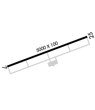
| Lat: N 4022.3 Long: W 08349.2 Elev: 1122 Var: +05 Longest Runway: 5000 | ||
| AWOS: 118.07 CTAF: 122.8 | ||
| ||||||||||||||||||||||||||||||||||||||||||||
| ||||||||||||||||||||||||||||||||||||||||||||
| ||||||||||||||||||||||||||||||||||||||||||||
| Rwy | Rwy | |||||||
| 5000x100 | 5000' | 5000x100 | 5000' | |||||
| Runway ID | Single Wheel | Double Wheel | Double Tandem Wheel | Dual Double Wheel |
| 07/25 | N/A | N/A | N/A | N/A |
| These numbers are Advisory and are not limits. The Airport Manager should have more accurate Weight Limits | ||||
 Airport Diagram might not be current. | |
| Facility Name: | BELLEFONTAINE RGNL |
| City Name: | BELLEFONTAINE |
| County: | LOGAN |
| State abbrev: | OH |
| State Name: | OHIO |
| Ownership: | PUBLICLY OWNED |
| Use: | OPEN TO THE PUBLIC |
| Owner's Name: | CITY OF BELLEFONTAINE |
| Address: | CITY HALL, 135 N DETROIT ST |
| BELLEFONTAINE, OH 43311-1474 | |
| Owner's Phone: | 937-592-4376 |
| Manager's Name: | STEVE BUCHENROTH |
| Address: | 3100 STATE ROUTE 47 W, PO BOX 87 |
| BELLEFONTAINE, OH 43311-9012 | |
| Phone: | 937-593-8210; CELL 937-597-2055. |
| FAA Region: | GREAT LAKES |
| FAA Field Office: | DET |
| Date | Sunrise | Sunset |
|---|---|---|
| 06/12/26 Friday | 6:05 | 21:06 |
| 06/13/26 Saturday | 6:05 | 21:06 |
| 06/14/26 Sunday | 6:05 | 21:07 |
| 06/15/26 Monday | 6:05 | 21:07 |
| 06/16/26 Tuesday | 6:05 | 21:07 |
| 06/17/26 Wednesday | 6:05 | 21:08 |
| 06/18/26 Thursday | 6:05 | 21:08 |
| 06/19/26 Friday | 6:05 | 21:08 |
| 06/20/26 Saturday | 6:05 | 21:09 |
| 06/21/26 Sunday | 6:05 | 21:09 |
| 06/22/26 Monday | 6:05 | 21:09 |
| 06/23/26 Tuesday | 6:06 | 21:09 |
| 06/24/26 Wednesday | 6:06 | 21:09 |
| 06/25/26 Thursday | 6:06 | 21:09 |
| Airport Attendance Schedule | MON-FRI 0800-DUSK, SAT-SUN 0800-1700 |
| Airport Status | OPERATIONAL (This Status can change at any time - please check NOTAMS) |
| Airport Lighting Schedule | ACTVT REIL RWY 07 & 25; MIRL RWY 07/25 - CTAF. PAPI RWY 07 & 25 OPR CONSLY. |
| Airport Storage Available | Tie Downs, Hanger |
| Extra Services Available | Flight Instruction, Aircraft Rental |
| Wind Indicator | YES - (lighted) |
| Control Tower | NO |
| CTAF Frequency | 122.800 |
| Unicom Frequency | 122.800 |
| Rotating Beacon Color | WG |
| Segmented Circle | NO |
| Landing Fee |
| Airport Inspected | STATE - performed by STATE AERONAUTICAL PERSONNEL |
| Inspection Date | 09/18/2024 |
| Type of Fuel Available | Grade 100LL, JET A-1 (icing inhibitor, freeze point -50C) |
| Airframe Repair Service | MAJOR |
| Power Plant Repair Service | MAJOR |
| Latitude | N4022.3 |
| Longitude | W08349.2 (ESTIMATED) |
| Arpt Elevation | 1121ft (SURVEYED) |
| Magnetic Variation | 05W |
| 3 miles W | of BELLEFONTAINE |
| Traffic Pattern Altitude | |
| Sectional Chart | DETROIT |
| Operations (Reported) | Yearly | Avg. Daily |
|---|---|---|
| General Aviation Transient | 0 | 0 |
| General Aviation Local | 0 | 0 |
| Air Taxi | 0 | 0 |
| Commerical | 0 | 0 |
| Commuter | 0 | 0 |
| Military | 0 | 0 |
| Aircraft based on Field | |
|---|---|
| General Aviation Singles | 0 |
| General Aviation Multi | 0 |
| Jet Aircraft | 0 |
| General Aviation Helicopters | 0 |
| Military Aircraft | 0 |
| Gliders | 0 |
| Ultralights | 0 |
| FSS on field | NO |
| FSS tie-in | DAYTON |
| FSS Phone | 1-800-WX-BRIEF |
| Who issues Notams | EDJ |
| Notam D service at airport | YES |
| ARTCC Name | INDIANAPOLIS |
| Airport Certification | |
| Aircraft Rescue & Firefighting Index | None |
| Airport of Entry | No |
| Custom Landing Rights | No |
| Joint Civil/Military | No |
| Military Landing rights | No |
| NATIONAL PLAN OF INTEGRATED AIRPORT SYSTEMS (NPIAS) |
| FOR CD CTC COLUMBUS APCH AT 614-338-8537. |
| OCNL DEER & COYOTES ON & INVOF ARPT. |
Airport Communications & Frequencies:
| ||||||||||||||
| Runway: 07 | Runway: 25 | ||
| Mag heading: | 74° | Mag heading: | 254° |
| Rwy Slope: | .36% Up | Rwy Slope: | -.36% Down |
| Approach: | Approach: | ||
| Pattern: | Left Traffic | Pattern: | Left Traffic |
| Markings: | NONPRECISION INSTRUMENT | Markings: | NONPRECISION INSTRUMENT |
| Marking Condition: | FAIR | Marking Condition: | FAIR |
| Arresting Dev: | Arresting Dev: | ||
| Lat & Long: | N4022.2 W08349.7 | Lat. & Long.: | N4022.5 W08348.7 |
| Elev: | 1103.7 ft. MSL | Elev: | 1121.5 ft. MSL |
| TCH: | 41 ft. AGL | TCH: | 57 ft. AGL |
| Visual Glide Path: | 3.00 degrees | Visual Glide Path: | 4.00 degrees |
| Displaced Threshold: | No | Displaced Threshold: | No |
| Touchdown Zone: | YES | Touchdown Zone: | YES |
| Touchdown Elev.: | 1111.7 feet | Touchdown Elev.: | 1121.6 feet |
| Visual Glide Slope: | 4-Light PAPI on LEFT side of Runway | Visual Glide Slope: | 4-Light PAPI on LEFT side of Runway |
| RVR Equipment: | RVR Equipment: | ||
| RVV Equipment: | NO | RVV Equipment: | NO |
| Approach Lights: | Approach Lights: | ||
| REIL: | YES | REIL: | YES |
| Centerline Lights: | NO | Centerline Lights: | NO |
| Touchdown lights: | NO | Touchdown lights: | NO |
| Runway Category: | Runway with a Non-precision Approach having visibility minimums greater than 3/4 mile | Runway Category: | Runway with a Non-precision Approach having visibility minimums greater than 3/4 mile |
| Declared Distances: | Declared Distances: |
Thanks for using FltPlan.com
all rights reserved © 1999-2026 by Flight Plan LLC
