
| CHIPPEWA VALLEY RGNL EAU CLAIRE WI |
| |
| Lat: N 4451.9 Long: W 09129.1 Elev: 913 Var: -01 Longest Runway: 8101 | ||
| Dept. ATIS: 126.02 Arr. ATIS: 126.02 Ground: 120.92 Tower: 118.57 | ||
| ||||||||||||||||||||||||||||||||||||||||||||
| ||||||||||||||||||||||||||||||||||||||||||||
| ||||||||||||||||||||||||||||||||||||||||||||
| ||||||||||||||||||||||||||||||||||||||||||||
| Rwy | Rwy | |||||||
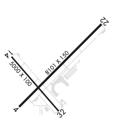
| 8101x150 | 7701' | 8101x150 | 8101' | 109.50 - 223° | ||||
| 5000x100 | 5000' | 5000x100 | 5000' | |||||
| Runway ID | Single Wheel | Double Wheel | Double Tandem Wheel | Dual Double Wheel |
| 04/22 | 100,000 | 130,000 | 220,000 | N/A |
| 14/32 | 55,000 | 70,000 | 125,000 | N/A |
| These numbers are Advisory and are not limits. The Airport Manager should have more accurate Weight Limits | ||||
 Airport Diagram might not be current. | |
| Facility Name: | CHIPPEWA VALLEY RGNL |
| City Name: | EAU CLAIRE |
| County: | CHIPPEWA |
| State abbrev: | WI |
| State Name: | WISCONSIN |
| Ownership: | PUBLICLY OWNED |
| Use: | OPEN TO THE PUBLIC |
| Owner's Name: | EAU CLAIRE COUNTY |
| Address: | 721 OXFORD AVE |
| EAU CLAIRE, WI 54701 | |
| Owner's Phone: | 715-839-4900 |
| Manager's Name: | CHARITY ZICH |
| Address: | 3800 STARR AVE; ADMIN@CHIPPEWAVALLEYAIRPORT.COM. |
| EAU CLAIRE, WI 54703 | |
| Phone: | 715-839-6241 |
| FAA Region: | GREAT LAKES |
| FAA Field Office: | CHI |
| Date | Sunrise | Sunset |
|---|---|---|
| 06/08/26 Monday | 5:20 | 20:50 |
| 06/09/26 Tuesday | 5:20 | 20:51 |
| 06/10/26 Wednesday | 5:20 | 20:51 |
| 06/11/26 Thursday | 5:19 | 20:52 |
| 06/12/26 Friday | 5:19 | 20:52 |
| 06/13/26 Saturday | 5:19 | 20:53 |
| 06/14/26 Sunday | 5:19 | 20:53 |
| 06/15/26 Monday | 5:19 | 20:54 |
| 06/16/26 Tuesday | 5:19 | 20:54 |
| 06/17/26 Wednesday | 5:19 | 20:55 |
| 06/18/26 Thursday | 5:19 | 20:55 |
| 06/19/26 Friday | 5:19 | 20:55 |
| 06/20/26 Saturday | 5:19 | 20:55 |
| 06/21/26 Sunday | 5:20 | 20:56 |
| Airport Attendance Schedule | 7 Days A Week 0700-2100; OTR ATNDNC TIMES CALL 715-839-4900. |
| Airport Status | OPERATIONAL (This Status can change at any time - please check NOTAMS) |
| Airport Lighting Schedule | WHEN ATCT CLSD HIRL RY 04/22 PRESET ON LOW INTST; TO INCR INTST & ACTVT MALSR RY 22; REIL RWY 4; HIRL RY 04/22; REIL RY 14; PAPI RYS 14 /32; MIRL RY 14/32 - CTAF. |
| Airport Storage Available | Tie Downs, Hanger |
| Extra Services Available | Air Freight, Air Ambulance, Charter, Flight Instruction, Aircraft Rental, Aircraft Sales |
| Wind Indicator | YES - (lighted) |
| Control Tower | YES |
| CTAF Frequency | 118.575 |
| Unicom Frequency | FBO SVCS AVBL ON 129.625. |
| Rotating Beacon Color | WG |
| Segmented Circle | YES |
| Landing Fee | NO |
| Airport Inspected | FEDERAL - performed by FAA AIRPORTS FIELD PERSONNEL |
| Inspection Date | 08/06/2025 |
| Type of Fuel Available | Grade 100LL, JET A (freeze point -40C) |
| Airframe Repair Service | MAJOR |
| Power Plant Repair Service | MAJOR |
| Latitude | N4451.9 |
| Longitude | W09129.1 (ESTIMATED) |
| Arpt Elevation | 913ft (SURVEYED) |
| Magnetic Variation | 01E |
| 3 miles N | of EAU CLAIRE |
| Traffic Pattern Altitude | |
| Sectional Chart | GREEN BAY |
| Operations (Reported) | Yearly | Avg. Daily |
|---|---|---|
| General Aviation Transient | 0 | 0 |
| General Aviation Local | 0 | 0 |
| Air Taxi | 0 | 0 |
| Commerical | 0 | 0 |
| Commuter | 0 | 0 |
| Military | 0 | 0 |
| Aircraft based on Field | |
|---|---|
| General Aviation Singles | 0 |
| General Aviation Multi | 0 |
| Jet Aircraft | 0 |
| General Aviation Helicopters | 0 |
| Military Aircraft | 0 |
| Gliders | 0 |
| Ultralights | 0 |
| FSS on field | NO |
| FSS tie-in | GREEN BAY |
| FSS Phone | 1-800-WX-BRIEF |
| Who issues Notams | EAU |
| Notam D service at airport | YES |
| ARTCC Name | MINNEAPOLIS |
| Airport Certification | AIRPORT RECEIVING SCHEDULED AIR CARRIER SERVICE FROM CARRIERS CERTIFICATED BY THE CIVIL AERONAUTICS BOARD; ARFF NOT AVBL 24 HRS. PPR FOR UNSCHEDULED ACR OPNS WITH MORE THAN 9 PASSENGER SEATS; CONTACT ARPT MGR 715-839-6241. ACR OPNS WITH MORE THAN 9 PASSENGER SEATS NA IN EXCESS OF 15 MIN BEFORE OR AFTER SKED ARR/DEP TIMES WITHOUT PPR WITH ARPT MGR AND CONFIRMATION ARFF IS AVLB PRIOR TO LDG OR TKF. |
| Aircraft Rescue & Firefighting Index | AIRPORT HAS A CERTIFICATE UNDER CFR PART 139 |
| Airport of Entry | No |
| Custom Landing Rights | No |
| Joint Civil/Military | No |
| Military Landing rights | YES |
| NATIONAL PLAN OF INTEGRATED AIRPORT SYSTEMS (NPIAS) |
| GRANT AGREEMENTS UNDER FAAP/ADAP/AIP |
| ASSURANCES PURSUANT TO TITLE VI, CIVIL RIGHTS ACT OF 1964 |
| AGREEMENT UNDER DLAND OR DCLA HAS EXPIRED. |
| ARPT CONDS UNMON 2200 - 0500. |
| DEER & BIRDS ON & INVOF ARPT. |
| FOR CD IF UNA TO CTC ON FSS FREQ, CTC MINNEAPOLIS ARTCC AT 651-463-5588. |
| ALL GA ACFT PARK AT FBO. |
| RWY 04/2 2 PCR VALUE: 420/R/C/W/T |
| RWY 14/3 2 PCR VALUE: 190/R/C/W/T |
Airport Communications & Frequencies:
| |||||||||||||||
| Runway: 04 | Runway: 22 | ||
| Mag heading: | 44° | Mag heading: | 224° |
| Rwy Slope: | .33% Up | Rwy Slope: | -.33% Down |
| Approach: | Approach: | ILS/DME | |
| Pattern: | Left Traffic | Pattern: | Left Traffic |
| Markings: | PRECISION INSTRUMENT | Markings: | PRECISION INSTRUMENT |
| Marking Condition: | GOOD | Marking Condition: | GOOD |
| Arresting Dev: | Arresting Dev: | ||
| Lat & Long: | N4451.6 W09129.6 | Lat. & Long.: | N4452.5 W09128.2 |
| Elev: | 886.6 ft. MSL | Elev: | 913.1 ft. MSL |
| TCH: | 44 ft. AGL | TCH: | 50 ft. AGL |
| Visual Glide Path: | 3.00 degrees | Visual Glide Path: | 3.00 degrees |
| Displaced Threshold: | 400 feet | Displaced Threshold: | No |
| Touchdown Zone: | YES | Touchdown Zone: | YES |
| Touchdown Elev.: | 888.7 feet | Touchdown Elev.: | 913.1 feet |
| Visual Glide Slope: | 4-Light PAPI on LEFT side of Runway; PAPI RWY 04 22 OPR CONSLY. | Visual Glide Slope: | 4-Light PAPI on LEFT side of Runway |
| RVR Equipment: | RVR Equipment: | ||
| RVV Equipment: | NO | RVV Equipment: | NO |
| Approach Lights: | Approach Lights: | MALSR - 1,400 foot medium intensity approach lighting system with runway alignment indicator lights | |
| REIL: | YES | REIL: | NO |
| Centerline Lights: | NO | Centerline Lights: | NO |
| Touchdown lights: | NO | Touchdown lights: | NO |
| Runway Category: | D | Runway Category: | Precision Instrument Runway |
| Declared Distances: | TORA:8101' TODA:8101' ASDA:8101' LDA:7701' | Declared Distances: | TORA:8101' TODA:8101' ASDA:7301' LDA:7301' |
| Obstructions: | ROAD | Obstructions: | |
| Marked: | NOT Marked/Lighted | Marked: | |
| Clearance slope: | APCH RATIO 50:1 AT DTHR. | Clearance slope: | 50:1 |
| Obstruction height: | 4 feet AGL | Obstruction height: | |
| Dist. from runway: | 140 feet | Dist. from runway: | |
| Centerline offset: | 481 left of centerline | Centerline offset: | |
| Comments: | ROAD 140 FT FM RWY END 481 FT LEFT OF CNTRLN. | Comments: |
| Runway: 14 | Runway: 32 | ||
| Mag heading: | 138° | Mag heading: | 318° |
| Rwy Slope: | .10% Up | Rwy Slope: | -.10% Down |
| Approach: | Approach: | ||
| Pattern: | Left Traffic | Pattern: | Left Traffic |
| Markings: | NONPRECISION INSTRUMENT | Markings: | NONPRECISION INSTRUMENT |
| Marking Condition: | GOOD | Marking Condition: | GOOD |
| Arresting Dev: | Arresting Dev: | ||
| Lat & Long: | N4452.1 W09129.7 | Lat. & Long.: | N4451.5 W09128.9 |
| Elev: | 882.8 ft. MSL | Elev: | 887.6 ft. MSL |
| TCH: | 43 ft. AGL | TCH: | 70 ft. AGL |
| Visual Glide Path: | 3.00 degrees | Visual Glide Path: | 4.00 degrees |
| Displaced Threshold: | No | Displaced Threshold: | No |
| Touchdown Zone: | YES | Touchdown Zone: | YES |
| Touchdown Elev.: | 886.8 feet | Touchdown Elev.: | 887.6 feet |
| Visual Glide Slope: | 4-Light PAPI on LEFT side of Runway | Visual Glide Slope: | 4-Light PAPI on LEFT side of Runway |
| RVR Equipment: | RVR Equipment: | ||
| RVV Equipment: | NO | RVV Equipment: | NO |
| Approach Lights: | Approach Lights: | ||
| REIL: | YES | REIL: | NO |
| Centerline Lights: | NO | Centerline Lights: | NO |
| Touchdown lights: | NO | Touchdown lights: | NO |
| Runway Category: | Runway with a Non-precision Approach | Runway Category: | Runway with a Non-precision Approach |
| Declared Distances: | TORA:5000' TODA:5000' ASDA:5000' LDA:5000' | Declared Distances: | TORA:5000' TODA:5000' ASDA:5000' LDA:5000' |
Thanks for using FltPlan.com
all rights reserved © 1999-2026 by Flight Plan LLC
