
| PANGBORN MEMORIAL WENATCHEE WA |
| |
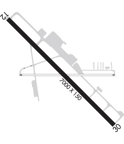
| Lat: N 4723.9 Long: W 12012.4 Elev: 1249 Var: -15 Longest Runway: 7000 | ||
| AWOS: 119.92 CTAF: 123.0 | ||
| ||||||||||||||||||||||||||||||||||||||||||||
| ||||||||||||||||||||||||||||||||||||||||||||
| ||||||||||||||||||||||||||||||||||||||||||||
| Rwy | Rwy | |||||||
| 7000x150 | 7000' | 109.35 - 120° | 7000x150 | 7000' | ||||
| Runway ID | Single Wheel | Double Wheel | Double Tandem Wheel | Dual Double Wheel |
| 12/30 | 116,000 | 192,000 | N/A | N/A |
| These numbers are Advisory and are not limits. The Airport Manager should have more accurate Weight Limits | ||||
 Airport Diagram might not be current. | |
| Facility Name: | PANGBORN MEML |
| City Name: | WENATCHEE |
| County: | DOUGLAS |
| State abbrev: | WA |
| State Name: | WASHINGTON |
| Ownership: | PUBLICLY OWNED |
| Use: | OPEN TO THE PUBLIC |
| Owner's Name: | PORTS CHELAN&DOUGLAS CNTY |
| Address: | 3764 AIRPORT WAY |
| EAST WENATCHEE, WA 98802 | |
| Owner's Phone: | 509-884-4700 |
| Manager's Name: | TRENT MOYERS |
| Address: | ONE CAMPBELL PARKWAY |
| EAST WENATCHEE, WA 98802 | |
| Phone: | 509-884-4700 |
| FAA Region: | NORTHWEST MOUNTAIN |
| FAA Field Office: | SEA |
| Date | Sunrise | Sunset |
|---|---|---|
| 06/08/26 Monday | 5:05 | 20:55 |
| 06/09/26 Tuesday | 5:04 | 20:56 |
| 06/10/26 Wednesday | 5:04 | 20:57 |
| 06/11/26 Thursday | 5:04 | 20:57 |
| 06/12/26 Friday | 5:04 | 20:58 |
| 06/13/26 Saturday | 5:04 | 20:58 |
| 06/14/26 Sunday | 5:03 | 20:59 |
| 06/15/26 Monday | 5:03 | 20:59 |
| 06/16/26 Tuesday | 5:03 | 21:00 |
| 06/17/26 Wednesday | 5:03 | 21:00 |
| 06/18/26 Thursday | 5:03 | 21:00 |
| 06/19/26 Friday | 5:04 | 21:01 |
| 06/20/26 Saturday | 5:04 | 21:01 |
| 06/21/26 Sunday | 5:04 | 21:01 |
| Airport Attendance Schedule | 7 Days A Week 0800-1800 |
| Airport Status | OPERATIONAL (This Status can change at any time - please check NOTAMS) |
| Airport Lighting Schedule | ACTVT MALSR RWY 12; REIL 30; HIRL RWY 12/30 - CTAF. PAPI RWY 12 & 30 OPR CONSLY. |
| Airport Storage Available | Tie Downs |
| Extra Services Available | Air Freight, Air Ambulance, Glider, Flight Instruction, Aircraft Rental, Glider Towing |
| Wind Indicator | YES - (lighted) |
| Control Tower | NO |
| CTAF Frequency | 123.000 |
| Unicom Frequency | 123.000 |
| Rotating Beacon Color | WG |
| Segmented Circle | YES |
| Landing Fee | YES |
| Airport Inspected | FEDERAL - performed by FAA AIRPORTS FIELD PERSONNEL |
| Inspection Date | 02/14/2025 |
| Type of Fuel Available | Grade 100LL, JET A (freeze point -40C) |
| Airframe Repair Service | MAJOR |
| Power Plant Repair Service | MAJOR |
| Latitude | N4723.9 |
| Longitude | W12012.4 (ESTIMATED) |
| Arpt Elevation | 1248ft (SURVEYED) |
| Magnetic Variation | 15E |
| 4 miles E | of WENATCHEE |
| Traffic Pattern Altitude | |
| Sectional Chart | SEATTLE |
| Operations (Reported) | Yearly | Avg. Daily |
|---|---|---|
| General Aviation Transient | 0 | 0 |
| General Aviation Local | 0 | 0 |
| Air Taxi | 0 | 0 |
| Commerical | 0 | 0 |
| Commuter | 0 | 0 |
| Military | 0 | 0 |
| Aircraft based on Field | |
|---|---|
| General Aviation Singles | 0 |
| General Aviation Multi | 0 |
| Jet Aircraft | 0 |
| General Aviation Helicopters | 0 |
| Military Aircraft | 0 |
| Gliders | 0 |
| Ultralights | 0 |
| FSS on field | NO |
| FSS tie-in | SEATTLE |
| FSS Phone | 1-800-WX-BRIEF |
| Who issues Notams | EAT |
| Notam D service at airport | YES |
| ARTCC Name | SEATTLE |
| Airport Certification | AIRPORT RECEIVING SCHEDULED AIR CARRIER SERVICE FROM CARRIERS CERTIFICATED BY THE CIVIL AERONAUTICS BOARD; 24 HR PPR FOR UNSKED ACR OPNS WITH MORE THAN 30 PAX SEATS CALL AP OPS (509) 860-1852. |
| Aircraft Rescue & Firefighting Index | AIRPORT HAS A CERTIFICATE UNDER CFR PART 139 |
| Airport of Entry | No |
| Custom Landing Rights | No |
| Joint Civil/Military | No |
| Military Landing rights | YES |
| NATIONAL PLAN OF INTEGRATED AIRPORT SYSTEMS (NPIAS) |
| GRANT AGREEMENTS UNDER FAAP/ADAP/AIP |
| ASSURANCES PURSUANT TO TITLE VI, CIVIL RIGHTS ACT OF 1964 |
| AGREEMENT UNDER DLAND OR DCLA HAS EXPIRED. |
| GLIDER ACTIVITY FROM MAR-NOV. |
| COLD TEMPERATURE AIRPORT. ALTITUDE CORRECTION REQUIRED AT OR BELOW -6C. |
| UAS ACTVTY 1.56 NM E OF THE EAT VOR, 400 FT & BLW DURG DALGT HRS. |
| FOR CD IF UNA TO CTC ON FSS FREQ, CTC SEATTLE ARTCC AT 253-351-3694. |
| RWY 12/3 0 PCR VALUE: 450/F/A/X/T |
Airport Communications & Frequencies:
| |||||||||
| Runway: 12 | Runway: 30 | ||
| Mag heading: | 120° | Mag heading: | 300° |
| Rwy Slope: | .20% Up | Rwy Slope: | -.20% Down |
| Approach: | ILS/DME | Approach: | |
| Pattern: | Right Traffic | Pattern: | Left Traffic |
| Markings: | PRECISION INSTRUMENT | Markings: | NONPRECISION INSTRUMENT |
| Marking Condition: | GOOD | Marking Condition: | GOOD |
| Arresting Dev: | Arresting Dev: | ||
| Lat & Long: | N4724.3 W12013.0 | Lat. & Long.: | N4723.5 W12011.8 |
| Elev: | 1216.8 ft. MSL | Elev: | 1231.0 ft. MSL |
| TCH: | 55 ft. AGL | TCH: | 60 ft. AGL |
| Visual Glide Path: | 3.60 degrees | Visual Glide Path: | 3.60 degrees |
| Displaced Threshold: | No | Displaced Threshold: | No |
| Touchdown Zone: | YES | Touchdown Zone: | YES |
| Touchdown Elev.: | 1225.4 feet | Touchdown Elev.: | 1231.8 feet |
| Visual Glide Slope: | 4-Light PAPI on LEFT side of Runway | Visual Glide Slope: | 4-Light PAPI on LEFT side of Runway; UNUSBL BYD 2.6 NM DUE TO TRRN. |
| RVR Equipment: | RVR Equipment: | ||
| RVV Equipment: | NO | RVV Equipment: | NO |
| Approach Lights: | MALSR - 1,400 foot medium intensity approach lighting system with runway alignment indicator lights | Approach Lights: | |
| REIL: | NO | REIL: | YES |
| Centerline Lights: | NO | Centerline Lights: | NO |
| Touchdown lights: | NO | Touchdown lights: | NO |
| Runway Category: | Precision Instrument Runway | Runway Category: | Precision Instrument Runway |
| Declared Distances: | TORA:7000' TODA:7000' ASDA:7000' LDA:7000' | Declared Distances: | TORA:7000' TODA:7000' ASDA:7000' LDA:7000' |
| Obstructions: | ROAD | Obstructions: | |
| Marked: | NOT Marked/Lighted | Marked: | |
| Clearance slope: | 16:1 | Clearance slope: | 50:1 |
| Obstruction height: | 18 feet AGL | Obstruction height: | |
| Dist. from runway: | 500 feet | Dist. from runway: | |
| Centerline offset: | 280 left of centerline | Centerline offset: | |
| Comments: | Comments: |
Thanks for using FltPlan.com
all rights reserved © 1999-2026 by Flight Plan LLC
