
| KEARNEY RGNL KEARNEY NE |
| |
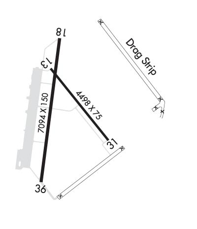
| Lat: N 4043.6 Long: W 09900.4 Elev: 2132 Var: -05 Longest Runway: 7094 | ||
| AWOS: 123.87 CTAF: 123.0 | ||
| ||||||||||||||||||||||||||||||||||||||||||||
| ||||||||||||||||||||||||||||||||||||||||||||
| ||||||||||||||||||||||||||||||||||||||||||||
| ||||||||||||||||||||||||||||||||||||||||||||
| Rwy | Rwy | |||||||
| 4498x75 | 4498' | 4498x75 | 4498' | |||||
| 7094x100 | 7094' | 7094x100 | 7094' | 110.90 - 002° | ||||
| Runway ID | Single Wheel | Double Wheel | Double Tandem Wheel | Dual Double Wheel |
| 13/31 | 30,000 | 38,000 | N/A | N/A |
| 18/36 | 46,000 | 62,000 | N/A | N/A |
| These numbers are Advisory and are not limits. The Airport Manager should have more accurate Weight Limits | ||||
 Airport Diagram might not be current. | |
| Facility Name: | KEARNEY RGNL |
| City Name: | KEARNEY |
| County: | BUFFALO |
| State abbrev: | NE |
| State Name: | NEBRASKA |
| Ownership: | PUBLICLY OWNED |
| Use: | OPEN TO THE PUBLIC |
| Owner's Name: | CITY OF KEARNEY |
| Address: | P.O. BOX 1180 |
| KEARNEY, NE 68848 | |
| Owner's Phone: | 308-233-3212 |
| Manager's Name: | JAMES LYNAUGH |
| Address: | P.O. BOX 1180 |
| KEARNEY, NE 68848 | |
| Phone: | 308-234-2318 |
| FAA Region: | CENTRAL |
| FAA Field Office: | NONE |

| Date | Sunrise | Sunset |
|---|---|---|
| 09/24/21 Friday | 7:25 | 19:30 |
| 09/25/21 Saturday | 7:26 | 19:28 |
| 09/26/21 Sunday | 7:27 | 19:27 |
| 09/27/21 Monday | 7:28 | 19:25 |
| 09/28/21 Tuesday | 7:29 | 19:23 |
| 09/29/21 Wednesday | 7:30 | 19:22 |
| 09/30/21 Thursday | 7:31 | 19:20 |
| 10/01/21 Friday | 7:32 | 19:18 |
| 10/02/21 Saturday | 7:33 | 19:17 |
| 10/03/21 Sunday | 7:34 | 19:15 |
| 10/04/21 Monday | 7:35 | 19:13 |
| 10/05/21 Tuesday | 7:36 | 19:12 |
| 10/06/21 Wednesday | 7:37 | 19:10 |
| 10/07/21 Thursday | 7:38 | 19:09 |
| Airport Attendance Schedule | 7 Days A Week 0600-2000 |
| Airport Status | OPERATIONAL (This Status can change at any time - please check NOTAMS) |
| Airport Lighting Schedule | HIRL RWY 18/36 PRESET ON LOW INTST; TO INCR INTST & ACTVT REIL RWY 18; MALSR RWY 36; PAPI RWYS 13, 18, 31, & 36; AND MIRL RWY 13/31 - CTAF. |
| Airport Storage Available | Tie Downs, Hanger |
| Extra Services Available | Air Freight, Crop Dusting, Air Ambulance, Charter, Flight Instruction, Aircraft Rental, Aircraft Sales |
| Wind Indicator | YES - (lighted) |
| Control Tower | NO |
| CTAF Frequency | 123.000 |
| Unicom Frequency | 123.000 |
| Rotating Beacon Color | CLEAR-GREEN (Light Land Airport) |
| Segmented Circle | YES |
| Landing Fee | NO |
| Airport Inspected | STATE - performed by FAA AIRPORTS FIELD PERSONNEL |
| Inspection Date | 10/18/2018 |
| Type of Fuel Available | Grade 100LL, JET A (freeze point -40C) |
| Airframe Repair Service | MAJOR |
| Power Plant Repair Service | MAJOR |
| Latitude | N4043.6 |
| Longitude | W09900.4 (ESTIMATED) |
| Arpt Elevation | 2131ft (SURVEYED) |
| Magnetic Variation | 05E |
| 4 miles NE | of KEARNEY |
| Traffic Pattern Altitude | |
| Sectional Chart | OMAHA |
| Operations (Reported) | Yearly | Avg. Daily |
|---|---|---|
| General Aviation Transient | 9000 | 25 |
| General Aviation Local | 10000 | 27 |
| Air Taxi | 550 | 2 |
| Commerical | 2190 | 6 |
| Commuter | 0 | 0 |
| Military | 30 | 0 |
| Aircraft based on Field | |
|---|---|
| General Aviation Singles | 20 |
| General Aviation Multi | 2 |
| Jet Aircraft | 3 |
| General Aviation Helicopters | 1 |
| Military Aircraft | 0 |
| Gliders | 0 |
| Ultralights | 0 |
| FSS on field | NO |
| FSS tie-in | COLUMBUS |
| FSS Phone | 1-800-WX-BRIEF |
| Who issues Notams | EAR |
| Notam D service at airport | YES |
| ARTCC Name | MINNEAPOLIS |
| Airport Certification | AIRPORT RECEIVING SCHEDULED AIR CARRIER SERVICE FROM CARRIERS CERTIFICATED BY THE CIVIL AERONAUTICS BOARD; ARFF INDEX B EQUIPMENT PROVIDED. PPR 48 HRS FOR AIR CARRIER OPS WITH MORE THAN 30 PASSENGER SEATS. CALL ARPT MGR 308-234-2318 OR 308-440-6069. |
| Aircraft Rescue & Firefighting Index | AIRPORT HAS A CERTIFICATE UNDER CFR PART 139 |
| Airport of Entry | No |
| Custom Landing Rights | No |
| Joint Civil/Military | No |
| Military Landing rights | YES |
| NATIONAL PLAN OF INTEGRATED AIRPORT SYSTEMS (NPIAS) |
| GRANT AGREEMENTS UNDER FAAP/ADAP/AIP |
| SURPLUS PROPERTY AGREEMENT UNDER PUBLIC LAW 289 |
| ASSURANCES PURSUANT TO TITLE VI, CIVIL RIGHTS ACT OF 1964 |
| BE ALERT WHEN TAXIING ON APRON DUE TO SEVERAL CLOSED AREAS. |
| AIR CARRIER OPS ARE NOT AUTHORIZED IN EXCESS OF 15 MINUTES BEFORE OR AFTER SCHEDULED ARRIVAL/DEPARTURE TIMES WITHOUT PRIOR COORDINATION WITH AMGR AND CONFIRMATION THAT ARFF IS AVBL PRIOR TO LDNG OR TKOF. |
| FOR CD IF UNA TO CTC ON FSS FREQ, CTC MINNEAPOLIS ARTCC AT 651-463-5588. |
Airport Communications & Frequencies:
| |||||||||
| Runway: 13 | Runway: 31 | ||
| Mag heading: | 136° | Mag heading: | 316° |
| Rwy Slope: | -.02% Down | Rwy Slope: | .02% Up |
| Approach: | Approach: | ||
| Pattern: | Left Traffic | Pattern: | Left Traffic |
| Markings: | NONPRECISION INSTRUMENT | Markings: | NONPRECISION INSTRUMENT |
| Marking Condition: | GOOD | Marking Condition: | GOOD |
| Arresting Dev: | Arresting Dev: | ||
| Lat & Long: | N4043.9 W09900.5 | Lat. & Long.: | N4043.4 W09859.9 |
| Elev: | 2129.2 ft. MSL | Elev: | 2128.4 ft. MSL |
| TCH: | 43 ft. AGL | TCH: | 44 ft. AGL |
| Visual Glide Path: | 3.00 degrees | Visual Glide Path: | 3.00 degrees |
| Displaced Threshold: | No | Displaced Threshold: | No |
| Touchdown Zone: | YES | Touchdown Zone: | YES |
| Touchdown Elev.: | 2130.4 feet | Touchdown Elev.: | 2128.4 feet |
| Visual Glide Slope: | 2-Light PAPI on LEFT side of Runway | Visual Glide Slope: | 2-Light PAPI on LEFT side of Runway |
| RVR Equipment: | RVR Equipment: | ||
| RVV Equipment: | NO | RVV Equipment: | NO |
| Approach Lights: | Approach Lights: | ||
| REIL: | NO | REIL: | NO |
| Centerline Lights: | NO | Centerline Lights: | NO |
| Touchdown lights: | NO | Touchdown lights: | NO |
| Runway Category: | Runway with a Non-precision Approach having visibility minimums greater than 3/4 mile | Runway Category: | Runway with a Visual Approach |
| Declared Distances: | TORA:4498' TODA:4498' ASDA:4498' LDA:4498' | Declared Distances: | TORA:4498' TODA:4498' ASDA:4498' LDA:4498' |
| Runway: 18 | Runway: 36 | ||
| Mag heading: | 182° | Mag heading: | 2° |
| Rwy Slope: | .05% Up | Rwy Slope: | -.05% Down |
| Approach: | Approach: | ILS/DME | |
| Pattern: | Left Traffic | Pattern: | Left Traffic |
| Markings: | NONPRECISION INSTRUMENT | Markings: | PRECISION INSTRUMENT |
| Marking Condition: | GOOD | Marking Condition: | GOOD |
| Arresting Dev: | Arresting Dev: | ||
| Lat & Long: | N4044.2 W09900.4 | Lat. & Long.: | N4043.0 W09900.6 |
| Elev: | 2127.8 ft. MSL | Elev: | 2131.6 ft. MSL |
| TCH: | 46 ft. AGL | TCH: | 43 ft. AGL |
| Visual Glide Path: | 3.00 degrees | Visual Glide Path: | 3.00 degrees |
| Displaced Threshold: | No | Displaced Threshold: | No |
| Touchdown Zone: | YES | Touchdown Zone: | YES |
| Touchdown Elev.: | 2130.5 feet | Touchdown Elev.: | 2131.8 feet |
| Visual Glide Slope: | 4-Light PAPI on LEFT side of Runway | Visual Glide Slope: | 4-Light PAPI on LEFT side of Runway |
| RVR Equipment: | RVR Equipment: | ||
| RVV Equipment: | NO | RVV Equipment: | NO |
| Approach Lights: | Approach Lights: | MALSR - 1,400 foot medium intensity approach lighting system with runway alignment indicator lights | |
| REIL: | YES | REIL: | NO |
| Centerline Lights: | NO | Centerline Lights: | NO |
| Touchdown lights: | NO | Touchdown lights: | NO |
| Runway Category: | D | Runway Category: | Precision Instrument Runway |
| Declared Distances: | TORA:7094' TODA:7094' ASDA:7094' LDA:7094' | Declared Distances: | TORA:7094' TODA:7094' ASDA:7094' LDA:7094' |
| Obstructions: | BLDG | Obstructions: | |
| Marked: | NOT Marked/Lighted | Marked: | |
| Clearance slope: | 49:1 | Clearance slope: | 50:1 |
| Obstruction height: | 103 feet AGL | Obstruction height: | |
| Dist. from runway: | 5250 feet | Dist. from runway: | |
| Centerline offset: | Centerline offset: | ||
| Comments: | Comments: |
Thanks for using FltPlan.com
all rights reserved © 1999-2021 by Flight Plan LLC