
| DENVER CITY DENVER CITY TX |
| |
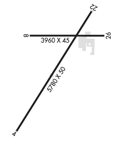
| Lat: N 3258.5 Long: W 10250.7 Elev: 3575 Var: -09 Longest Runway: 5780 | ||
| CTAF: 122.8 | ||
| ||||||||||||||||||||||||||||||||
| ||||||||||||||||||||||||||||||||
| Rwy | Rwy | |||||||
| 5780x50 | 5430' | 5780x50 | 5625' | |||||
| 3960x45 | 3781' | 3960x45 | 3434' | |||||
| Runway ID | Single Wheel | Double Wheel | Double Tandem Wheel | Dual Double Wheel |
| 04/22 | 13,000 | N/A | N/A | N/A |
| 08/26 | 13,000 | N/A | N/A | N/A |
| These numbers are Advisory and are not limits. The Airport Manager should have more accurate Weight Limits | ||||
| FltPlan does not have IFR approach charts available for KE57. |
 Airport Diagram might not be current. | |
| Facility Name: | DENVER CITY |
| City Name: | DENVER CITY |
| County: | YOAKUM |
| State abbrev: | TX |
| State Name: | TEXAS |
| Ownership: | PRIVATELY OWNED |
| Use: | OPEN TO THE PUBLIC |
| Owner's Name: | EXXON CORP, U.S.A.; PROPERTY LEASED BY CITY AND COUNTY. |
| Address: | EXXON BLDG, PO BOX 2180 |
| HOUSTON, TX 77001 | |
| Owner's Phone: | 713-656-3636 |
| Manager's Name: | STAN DAVID |
| Address: | PO BOX 1539 |
| DENVER CITY, TX 79323 | |
| Phone: | 806-592-5426 |
| FAA Region: | SOUTHWEST |
| FAA Field Office: | TEX |
| Date | Sunrise | Sunset |
|---|---|---|
| 09/24/21 Friday | 7:41 | 19:46 |
| 09/25/21 Saturday | 7:41 | 19:44 |
| 09/26/21 Sunday | 7:42 | 19:43 |
| 09/27/21 Monday | 7:43 | 19:42 |
| 09/28/21 Tuesday | 7:43 | 19:40 |
| 09/29/21 Wednesday | 7:44 | 19:39 |
| 09/30/21 Thursday | 7:45 | 19:38 |
| 10/01/21 Friday | 7:45 | 19:36 |
| 10/02/21 Saturday | 7:46 | 19:35 |
| 10/03/21 Sunday | 7:47 | 19:34 |
| 10/04/21 Monday | 7:47 | 19:32 |
| 10/05/21 Tuesday | 7:48 | 19:31 |
| 10/06/21 Wednesday | 7:49 | 19:30 |
| 10/07/21 Thursday | 7:50 | 19:28 |
| Airport Attendance Schedule | IRREGULAR |
| Airport Status | OPERATIONAL (This Status can change at any time - please check NOTAMS) |
| Airport Lighting Schedule | SS-SR |
| Airport Storage Available | Tie Downs |
| Extra Services Available | Crop Dusting, Flight Instruction |
| Wind Indicator | YES - (lighted) |
| Control Tower | NO |
| CTAF Frequency | 122.800 |
| Unicom Frequency | 122.800 |
| Rotating Beacon Color | CLEAR-GREEN (Light Land Airport) |
| Segmented Circle | YES |
| Landing Fee | NO |
| Airport Inspected | STATE - performed by STATE AERONAUTICAL PERSONNEL |
| Inspection Date | 06/20/2018 |
| Type of Fuel Available | Grade 100LL, JET A (freeze point -40C); -10FUEL AVBL SELF-SERVE WITH CREDIT CARD. |
| Airframe Repair Service | NONE |
| Power Plant Repair Service | NONE |
| Latitude | N3258.5 |
| Longitude | W10250.7 (ESTIMATED) |
| Arpt Elevation | 3575ft (ESTIMATED) |
| Magnetic Variation | 09E |
| 1 miles NW | of DENVER CITY |
| Traffic Pattern Altitude | |
| Sectional Chart | ALBUQUERQUE |
| Operations (Reported) | Yearly | Avg. Daily |
|---|---|---|
| General Aviation Transient | 500 | 1 |
| General Aviation Local | 1000 | 3 |
| Air Taxi | 0 | 0 |
| Commerical | 0 | 0 |
| Commuter | 0 | 0 |
| Military | 0 | 0 |
| Aircraft based on Field | |
|---|---|
| General Aviation Singles | 12 |
| General Aviation Multi | 0 |
| Jet Aircraft | 0 |
| General Aviation Helicopters | 0 |
| Military Aircraft | 0 |
| Gliders | 0 |
| Ultralights | 0 |
| FSS on field | NO |
| FSS tie-in | FORT WORTH |
| FSS Phone | 1-800-WX-BRIEF |
| Who issues Notams | FTW |
| Notam D service at airport | YES |
| ARTCC Name | FORT WORTH |
| Airport Certification | |
| Aircraft Rescue & Firefighting Index | None |
| Airport of Entry | No |
| Custom Landing Rights | No |
| Joint Civil/Military | No |
| Military Landing rights | No |
| ENTRANCE ROAD 20 FT HGRS & 4 FT FENCES OBSTRUCT PRIMARY SFC OF RWY 08/26. |
| 7 FT OILWELL HEAD 85 FT LEFT OF CNTRLN 602 FT SW OF RWY 22 THR OBSTRUCTS PRIMARY SFC. |
| LGTD DRILLING RIGS ON & INVOF ARPT. |
| FOR CD CTC FORT WORTH ARTCC AT 817-858-7584. |
| Runway: 04 | Runway: 22 | ||
| Mag heading: | 37° | Mag heading: | 217° |
| Rwy Slope: | -.02% Down | Rwy Slope: | .02% Up |
| Approach: | Approach: | ||
| Pattern: | Left Traffic | Pattern: | Right Traffic |
| Markings: | BASIC | Markings: | BASIC |
| Marking Condition: | FAIR | Marking Condition: | FAIR |
| Arresting Dev: | Arresting Dev: | ||
| Lat & Long: | N3258.1 W10251.2 | Lat. & Long.: | N3258.7 W10250.4 |
| Elev: | 3572.0 ft. MSL | Elev: | 3571.0 ft. MSL |
| TCH: | 64 ft. AGL | TCH: | 43 ft. AGL |
| Visual Glide Path: | 4.50 degrees | Visual Glide Path: | 4.00 degrees |
| Displaced Threshold: | 350 feet | Displaced Threshold: | 155 feet |
| Touchdown Zone: | NO | Touchdown Zone: | NO |
| Touchdown Elev.: | Touchdown Elev.: | ||
| Visual Glide Slope: | 2-Light PAPI on LEFT side of Runway; PAPI OTS. | Visual Glide Slope: | 2-Light PAPI on LEFT side of Runway; PAPI OTS. |
| RVR Equipment: | RVR Equipment: | ||
| RVV Equipment: | NO | RVV Equipment: | NO |
| Approach Lights: | Approach Lights: | ||
| REIL: | NO | REIL: | NO |
| Centerline Lights: | NO | Centerline Lights: | NO |
| Touchdown lights: | NO | Touchdown lights: | NO |
| Runway Category: | Runway with a Visual Approach | Runway Category: | Runway with a Visual Approach |
| Declared Distances: | Declared Distances: | ||
| Obstructions: | ROAD | Obstructions: | FENCE |
| Marked: | NOT Marked/Lighted | Marked: | NOT Marked/Lighted |
| Clearance slope: | APCH SLOPE 0:1 BASED ON DSPLCD THLD; +4 FT FENCE AT DSPLCD THLD 102 FT R; 20 FT PLINE AT 120 FT RIGHT OF DSPLCD THLD. | Clearance slope: | 1:1; APCH SLOPE 0:1 BASED ON DSPLCD THLD; +4 FT FENCE AT DSPLCD THLD 91 FT L. |
| Obstruction height: | 13 feet AGL | Obstruction height: | 10 feet AGL |
| Dist. from runway: | 200 feet | Dist. from runway: | 210 feet |
| Centerline offset: | Centerline offset: | 135 feet left of centerline | |
| Comments: | 4 FT FENCE AT THR 102 FT RIGHT; 13 FT ROAD 0-200 FT FM END, 4 FT FENCE 96 FT LEFT. | Comments: | 4 FT FENCE AT THLD 91 FT LEFT; DIRT ROAD 123 FT FM THLD, 6 FT SCATTERED TREES AND BRUSH 0-200 FT FM THLD ACROSS APCH. |
| Runway: 08 | Runway: 26 | ||
| Mag heading: | 80° | Mag heading: | 260° |
| Rwy Slope: | -.15% Down | Rwy Slope: | .15% Up |
| Approach: | Approach: | ||
| Pattern: | Left Traffic | Pattern: | Right Traffic |
| Markings: | BASIC | Markings: | BASIC |
| Marking Condition: | FAIR | Marking Condition: | FAIR; MARKINGS ARE NONSTD AT 45 FT IN HEIGHT |
| Arresting Dev: | Arresting Dev: | ||
| Lat & Long: | N3258.6 W10251.0 | Lat. & Long.: | N3258.6 W10250.2 |
| Elev: | 3575.0 ft. MSL | Elev: | 3569.0 ft. MSL |
| TCH: | TCH: | ||
| Visual Glide Path: | Visual Glide Path: | ||
| Displaced Threshold: | 179 feet | Displaced Threshold: | 526 feet |
| Touchdown Zone: | NO | Touchdown Zone: | NO |
| Touchdown Elev.: | Touchdown Elev.: | ||
| Visual Glide Slope: | Visual Glide Slope: | ||
| RVR Equipment: | RVR Equipment: | ||
| RVV Equipment: | NO | RVV Equipment: | NO |
| Approach Lights: | Approach Lights: | ||
| REIL: | NO | REIL: | NO |
| Centerline Lights: | NO | Centerline Lights: | NO |
| Touchdown lights: | NO | Touchdown lights: | NO |
| Runway Category: | Runway with a Visual Approach | Runway Category: | Runway with a Visual Approach |
| Declared Distances: | Declared Distances: | ||
| Obstructions: | TREES | Obstructions: | PLINE |
| Marked: | NOT Marked/Lighted | Marked: | MARKED |
| Clearance slope: | APCH SLOPE 0:1 BASED ON DSPLCD THLD; +4 FT FENCE AT DSPLCD THLD 75 FT L. | Clearance slope: | APCH SLOPE 0:1 BASED ON DSPLCD THLD; +4 FT FENCE AT DSPLCD THLD 75 FT R. |
| Obstruction height: | 6 feet AGL | Obstruction height: | 35 feet AGL |
| Dist. from runway: | 200 feet | Dist. from runway: | 200 feet |
| Centerline offset: | Centerline offset: | 52 feet right of centerline | |
| Comments: | 4 FT FENCE 75 FT LEFT AT THR, 6 FT SCATTERED TREES 0-200 FT FM THR ON BOTH SIDES OF CNTRLN. | Comments: | 35 FT PLINE 54 FT FM END 84 FT RIGHT; ROAD & 4 FT FENCE 50 FT FM END, 9 FT TREES AT THLD; 74 FT R, 4 FT FENCE 69 FT LEFT. |
Thanks for using FltPlan.com
all rights reserved © 1999-2021 by Flight Plan LLC
