
| REAGAN COUNTY BIG LAKE TX |
| |
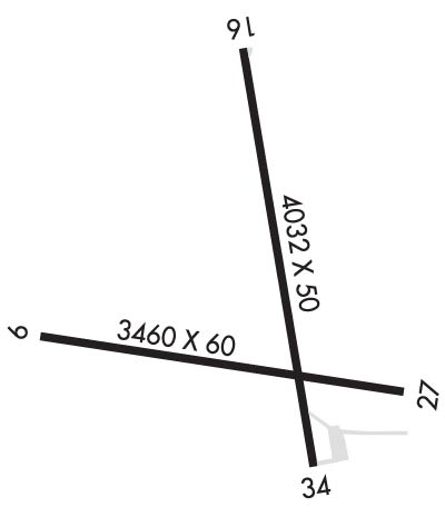
| Lat: N 3111.9 Long: W 10128.5 Elev: 2706 Var: -08 Longest Runway: 4032 | ||
| CTAF: 122.9 | ||
| ||||||
|
| Rwy | Rwy | |||||||
| 4000x60 | 4000' | 4000x60 | 4000' | |||||
| 4032x50 | 4032' | 4032x50 | 4032' | |||||
| Runway ID | Single Wheel | Double Wheel | Double Tandem Wheel | Dual Double Wheel |
| 09/27 | N/A | N/A | N/A | N/A |
| 16/34 | 14,000 | N/A | N/A | N/A |
| These numbers are Advisory and are not limits. The Airport Manager should have more accurate Weight Limits | ||||
 Airport Diagram might not be current. | |
| Facility Name: | REAGAN COUNTY |
| City Name: | BIG LAKE |
| County: | REAGAN |
| State abbrev: | TX |
| State Name: | TEXAS |
| Ownership: | PUBLICLY OWNED |
| Use: | OPEN TO THE PUBLIC |
| Owner's Name: | REAGAN COUNTY |
| Address: | COURTHOUSE |
| BIG LAKE, TX 76932 | |
| Owner's Phone: | 325-884-2665 |
| Manager's Name: | HEATH HOLT; COUNTY JUDGE. |
| Address: | P. O BOX 100 |
| BIG LAKE, TX 76932 | |
| Phone: | 325-650-1314 |
| FAA Region: | SOUTHWEST |
| FAA Field Office: | TEX |
| Date | Sunrise | Sunset |
|---|---|---|
| 09/24/21 Friday | 7:35 | 19:40 |
| 09/25/21 Saturday | 7:36 | 19:39 |
| 09/26/21 Sunday | 7:36 | 19:38 |
| 09/27/21 Monday | 7:37 | 19:36 |
| 09/28/21 Tuesday | 7:38 | 19:35 |
| 09/29/21 Wednesday | 7:38 | 19:34 |
| 09/30/21 Thursday | 7:39 | 19:32 |
| 10/01/21 Friday | 7:39 | 19:31 |
| 10/02/21 Saturday | 7:40 | 19:30 |
| 10/03/21 Sunday | 7:41 | 19:29 |
| 10/04/21 Monday | 7:41 | 19:27 |
| 10/05/21 Tuesday | 7:42 | 19:26 |
| 10/06/21 Wednesday | 7:43 | 19:25 |
| 10/07/21 Thursday | 7:43 | 19:24 |
| Airport Attendance Schedule | UNATTENDED |
| Airport Status | OPERATIONAL (This Status can change at any time - please check NOTAMS) |
| Airport Lighting Schedule | ACTVT PAPI RWY 16 & 34; MIRL RWY 16/34 - CTAF. |
| Airport Storage Available | Tie Downs, Hanger |
| Extra Services Available | NONE |
| Wind Indicator | YES - (lighted) |
| Control Tower | NO |
| CTAF Frequency | 122.900 |
| Unicom Frequency | |
| Rotating Beacon Color | CLEAR-GREEN (Light Land Airport) |
| Segmented Circle | YES |
| Landing Fee | NO |
| Airport Inspected | STATE - performed by PRIVATE CONTRACT PERSONNEL |
| Inspection Date | 05/18/2021 |
| Type of Fuel Available | Grade 100LL; -10FOR FUEL CALL 325-277-1551 |
| Airframe Repair Service | NONE |
| Power Plant Repair Service | NONE |
| Latitude | N3111.9 |
| Longitude | W10128.5 (ESTIMATED) |
| Arpt Elevation | 2705ft (SURVEYED) |
| Magnetic Variation | 08E |
| 1 miles W | of BIG LAKE |
| Traffic Pattern Altitude | |
| Sectional Chart | SAN ANTONIO |
| Operations (Reported) | Yearly | Avg. Daily |
|---|---|---|
| General Aviation Transient | 300 | 1 |
| General Aviation Local | 600 | 2 |
| Air Taxi | 0 | 0 |
| Commerical | 0 | 0 |
| Commuter | 0 | 0 |
| Military | 0 | 0 |
| Aircraft based on Field | |
|---|---|
| General Aviation Singles | 6 |
| General Aviation Multi | 1 |
| Jet Aircraft | 0 |
| General Aviation Helicopters | 3 |
| Military Aircraft | 0 |
| Gliders | 0 |
| Ultralights | 0 |
| FSS on field | NO |
| FSS tie-in | SAN ANGELO |
| FSS Phone | 1-800-WX-BRIEF |
| Who issues Notams | SJT |
| Notam D service at airport | YES |
| ARTCC Name | FORT WORTH |
| Airport Certification | |
| Aircraft Rescue & Firefighting Index | None |
| Airport of Entry | No |
| Custom Landing Rights | No |
| Joint Civil/Military | No |
| Military Landing rights | No |
| FOR CD CTC FORT WORTH ARTCC AT 817-858-7584. |
Airport Communications & Frequencies:
| |||||||
| Runway: 09 | Runway: 27 | ||
| Mag heading: | 91° | Mag heading: | 271° |
| Rwy Slope: | .05% Up | Rwy Slope: | -.05% Down |
| Approach: | Approach: | ||
| Pattern: | Left Traffic | Pattern: | Right Traffic |
| Markings: | BASIC | Markings: | BASIC |
| Marking Condition: | GOOD | Marking Condition: | GOOD |
| Arresting Dev: | Arresting Dev: | ||
| Lat & Long: | N3111.9 W10129.1 | Lat. & Long.: | N3111.7 W10128.3 |
| Elev: | 2690.0 ft. MSL | Elev: | 2692.0 ft. MSL |
| TCH: | TCH: | ||
| Visual Glide Path: | Visual Glide Path: | ||
| Displaced Threshold: | No | Displaced Threshold: | No |
| Touchdown Zone: | YES | Touchdown Zone: | YES |
| Touchdown Elev.: | 2690.0 feet | Touchdown Elev.: | 2692.0 feet |
| Visual Glide Slope: | Visual Glide Slope: | ||
| RVR Equipment: | RVR Equipment: | ||
| RVV Equipment: | NO | RVV Equipment: | NO |
| Approach Lights: | Approach Lights: | ||
| REIL: | NO | REIL: | NO |
| Centerline Lights: | NO | Centerline Lights: | NO |
| Touchdown lights: | NO | Touchdown lights: | NO |
| Runway Category: | Runway with a Visual Approach | Runway Category: | Runway with a Visual Approach |
| Declared Distances: | Declared Distances: | ||
| Obstructions: | Obstructions: | POLE | |
| Marked: | Marked: | NOT Marked/Lighted | |
| Clearance slope: | 50:1 | Clearance slope: | 23:1 |
| Obstruction height: | Obstruction height: | 61 feet AGL | |
| Dist. from runway: | Dist. from runway: | 1606 feet | |
| Centerline offset: | Centerline offset: | 58 feet left of centerline | |
| Comments: | Comments: |
| Runway: 16 | Runway: 34 | ||
| Mag heading: | 161° | Mag heading: | 341° |
| Rwy Slope: | -.13% Down | Rwy Slope: | .13% Up |
| Approach: | Approach: | ||
| Pattern: | Right Traffic | Pattern: | Left Traffic |
| Markings: | NONPRECISION INSTRUMENT | Markings: | NONPRECISION INSTRUMENT |
| Marking Condition: | GOOD | Marking Condition: | GOOD |
| Arresting Dev: | Arresting Dev: | ||
| Lat & Long: | N3112.3 W10128.4 | Lat. & Long.: | N3111.6 W10128.3 |
| Elev: | 2704.7 ft. MSL | Elev: | 2699.5 ft. MSL |
| TCH: | 30 ft. AGL | TCH: | 40 ft. AGL |
| Visual Glide Path: | 3.00 degrees | Visual Glide Path: | 3.50 degrees |
| Displaced Threshold: | No | Displaced Threshold: | No |
| Touchdown Zone: | YES | Touchdown Zone: | YES |
| Touchdown Elev.: | 2705.7 feet | Touchdown Elev.: | 2704.9 feet |
| Visual Glide Slope: | 2-Light PAPI on LEFT side of Runway | Visual Glide Slope: | 2-Light PAPI on LEFT side of Runway |
| RVR Equipment: | RVR Equipment: | ||
| RVV Equipment: | NO | RVV Equipment: | NO |
| Approach Lights: | Approach Lights: | ||
| REIL: | NO | REIL: | NO |
| Centerline Lights: | NO | Centerline Lights: | NO |
| Touchdown lights: | NO | Touchdown lights: | NO |
| Runway Category: | Runway with a Non-precision Approach | Runway Category: | Runway with a Visual Approach |
| Declared Distances: | Declared Distances: | ||
| Obstructions: | Obstructions: | POLE | |
| Marked: | Marked: | NOT Marked/Lighted | |
| Clearance slope: | 50:1 | Clearance slope: | 12:1 |
| Obstruction height: | Obstruction height: | 44 feet AGL | |
| Dist. from runway: | Dist. from runway: | 764 feet | |
| Centerline offset: | Centerline offset: | 165 feet right of centerline | |
| Comments: | Comments: |
Thanks for using FltPlan.com
all rights reserved © 1999-2021 by Flight Plan LLC
