
| BRUCE FIELD BALLINGER TX |
| |
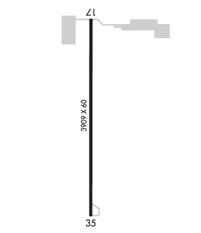
| Lat: N 3140.5 Long: W 09958.6 Elev: 1739 Var: -08 Longest Runway: 3909 | ||
| CTAF: 122.9 | ||
| ||||||||||||||||||||||||||||||||||||||||||||
| ||||||||||||||||||||||||||||||||||||||||||||
| Rwy | Rwy | |||||||
| 3909x60 | 3909' | 3909x60 | 3909' | |||||
| Runway ID | Single Wheel | Double Wheel | Double Tandem Wheel | Dual Double Wheel |
| 17/35 | 20,000 | N/A | N/A | N/A |
| These numbers are Advisory and are not limits. The Airport Manager should have more accurate Weight Limits | ||||
 Airport Diagram might not be current. | |
| Facility Name: | BRUCE FLD |
| City Name: | BALLINGER |
| County: | RUNNELS |
| State abbrev: | TX |
| State Name: | TEXAS |
| Ownership: | PUBLICLY OWNED |
| Use: | OPEN TO THE PUBLIC |
| Owner's Name: | CITY OF BALLINGER |
| Address: | PO BOX 497 |
| BALLINGER, TX 76821 | |
| Owner's Phone: | (325) 365-3511 |
| Manager's Name: | BRENT ALLEN |
| Address: | P.O. BOX 497 |
| BALLINGER, TX 76821 | |
| Phone: | (325) 365-3591 |
| FAA Region: | SOUTHWEST |
| FAA Field Office: | TEX |
| Date | Sunrise | Sunset |
|---|---|---|
| 09/24/21 Friday | 7:29 | 19:34 |
| 09/25/21 Saturday | 7:30 | 19:33 |
| 09/26/21 Sunday | 7:30 | 19:32 |
| 09/27/21 Monday | 7:31 | 19:30 |
| 09/28/21 Tuesday | 7:32 | 19:29 |
| 09/29/21 Wednesday | 7:32 | 19:28 |
| 09/30/21 Thursday | 7:33 | 19:26 |
| 10/01/21 Friday | 7:34 | 19:25 |
| 10/02/21 Saturday | 7:34 | 19:24 |
| 10/03/21 Sunday | 7:35 | 19:23 |
| 10/04/21 Monday | 7:36 | 19:21 |
| 10/05/21 Tuesday | 7:36 | 19:20 |
| 10/06/21 Wednesday | 7:37 | 19:19 |
| 10/07/21 Thursday | 7:37 | 19:18 |
| Airport Attendance Schedule | UNATTENDED |
| Airport Status | OPERATIONAL (This Status can change at any time - please check NOTAMS) |
| Airport Lighting Schedule | DUSK-DAWN. ACTVT PAPI RWY 17 - CTAF. |
| Airport Storage Available | Tie Downs |
| Extra Services Available | Crop Dusting |
| Wind Indicator | YES - (lighted) |
| Control Tower | NO |
| CTAF Frequency | 122.900 |
| Unicom Frequency | |
| Rotating Beacon Color | CLEAR-GREEN (Light Land Airport) |
| Segmented Circle | YES |
| Landing Fee | NO |
| Airport Inspected | STATE - performed by PRIVATE CONTRACT PERSONNEL |
| Inspection Date | 05/23/2021 |
| Type of Fuel Available | Grade 100LL; -10FOR FUEL CALL 325-365-3511. CASH OR CHECK ONLY. |
| Airframe Repair Service | None |
| Power Plant Repair Service | None |
| Latitude | N3140.5 |
| Longitude | W09958.6 (ESTIMATED) |
| Arpt Elevation | 1738ft (SURVEYED) |
| Magnetic Variation | 08E |
| 5 miles SW | of BALLINGER |
| Traffic Pattern Altitude | |
| Sectional Chart | SAN ANTONIO |
| Operations (Reported) | Yearly | Avg. Daily |
|---|---|---|
| General Aviation Transient | 1600 | 4 |
| General Aviation Local | 3200 | 9 |
| Air Taxi | 0 | 0 |
| Commerical | 0 | 0 |
| Commuter | 0 | 0 |
| Military | 0 | 0 |
| Aircraft based on Field | |
|---|---|
| General Aviation Singles | 16 |
| General Aviation Multi | 1 |
| Jet Aircraft | 0 |
| General Aviation Helicopters | 0 |
| Military Aircraft | 0 |
| Gliders | 0 |
| Ultralights | 0 |
| FSS on field | NO |
| FSS tie-in | SAN ANGELO |
| FSS Phone | 1-800-WX-BRIEF |
| Who issues Notams | SJT |
| Notam D service at airport | YES |
| ARTCC Name | FORT WORTH |
| Airport Certification | |
| Aircraft Rescue & Firefighting Index | None |
| Airport of Entry | No |
| Custom Landing Rights | No |
| Joint Civil/Military | No |
| Military Landing rights | YES |
| SURPLUS PROPERTY AGREEMENT UNDER REGULATION 16-WAA |
| THIS AIRPORT HAS BEEN SURVEYED BY THE NATIONAL GEODETIC SURVEY. |
| DEER ON & INVOF ARPT. |
| FOR CD CTC SAN ANGELO APCH AT 432-563-2123. WHEN APCH CLSD CTC FORT WORTH ARTCC AT 817-858-7584. |
| AIRFIELD LTG NOT MNTND. NMRS LGTS OTS. |
| RWY 17/3 5 VEGETATION GROWING THROUGH PVMNT. |
Airport Communications & Frequencies:
| |||||||||||||||
| Runway: 17 | Runway: 35 | ||
| Mag heading: | 172° | Mag heading: | 352° |
| Rwy Slope: | .08% Up | Rwy Slope: | -.08% Down |
| Approach: | Approach: | ||
| Pattern: | Left Traffic | Pattern: | Left Traffic |
| Markings: | NONPRECISION INSTRUMENT | Markings: | NONPRECISION INSTRUMENT |
| Marking Condition: | GOOD | Marking Condition: | GOOD |
| Arresting Dev: | Arresting Dev: | ||
| Lat & Long: | N3140.8 W09958.6 | Lat. & Long.: | N3140.1 W09958.6 |
| Elev: | 1735.2 ft. MSL | Elev: | 1738.4 ft. MSL |
| TCH: | 40 ft. AGL | TCH: | |
| Visual Glide Path: | 3.00 degrees | Visual Glide Path: | |
| Displaced Threshold: | No | Displaced Threshold: | No |
| Touchdown Zone: | YES | Touchdown Zone: | YES |
| Touchdown Elev.: | 1738.0 feet | Touchdown Elev.: | 1738.5 feet |
| Visual Glide Slope: | 2-Light PAPI on LEFT side of Runway | Visual Glide Slope: | |
| RVR Equipment: | RVR Equipment: | ||
| RVV Equipment: | NO | RVV Equipment: | NO |
| Approach Lights: | Approach Lights: | ||
| REIL: | NO | REIL: | NO |
| Centerline Lights: | NO | Centerline Lights: | NO |
| Touchdown lights: | NO | Touchdown lights: | NO |
| Runway Category: | Runway with a Non-precision Approach | Runway Category: | Runway with a Non-precision Approach |
| Declared Distances: | Declared Distances: | ||
| Obstructions: | ROAD | Obstructions: | |
| Marked: | NOT Marked/Lighted | Marked: | |
| Clearance slope: | 21:1 | Clearance slope: | 50:1 |
| Obstruction height: | 15 feet AGL | Obstruction height: | |
| Dist. from runway: | 520 feet | Dist. from runway: | |
| Centerline offset: | Centerline offset: | ||
| Comments: | Comments: |
Thanks for using FltPlan.com
all rights reserved © 1999-2021 by Flight Plan LLC
