
| LEA COUNTY/JAL/ JAL NM |
| |
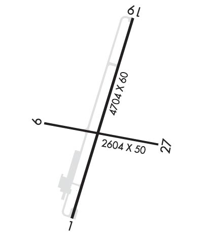
| Lat: N 3207.9 Long: W 10309.3 Elev: 3118 Var: -09 Longest Runway: 4704 | ||
| CTAF: 122.9 | ||
| ||||||||||||||||||||||||||||||||
| ||||||||||||||||||||||||||||||||
| Rwy | Rwy | |||||||
| 4704x60 | 4704' | 4704x60 | 4704' | |||||
| 2604x50 | 2564' | 2604x50 | 2559' | |||||
| Runway ID | Single Wheel | Double Wheel | Double Tandem Wheel | Dual Double Wheel |
| 01/19 | 23,000 | N/A | N/A | N/A |
| 09/27 | 12,000 | N/A | N/A | N/A |
| These numbers are Advisory and are not limits. The Airport Manager should have more accurate Weight Limits | ||||
 Airport Diagram might not be current. | |
| Facility Name: | LEA COUNTY/JAL/ |
| City Name: | JAL |
| County: | LEA |
| State abbrev: | NM |
| State Name: | NEW MEXICO |
| Ownership: | PUBLICLY OWNED |
| Use: | OPEN TO THE PUBLIC |
| Owner's Name: | LEA COUNTY |
| Address: | PO BOX 1106 |
| HOBBS, NM 88241-1106 | |
| Owner's Phone: | 575-391-2934 |
| Manager's Name: | CORY NEEDHAM; PUBLIC WORKS DIRECTOR. |
| Address: | PO BOX 1106 |
| HOBBS, NM 88241-1106 | |
| Phone: | 575-391-2934 |
| FAA Region: | SOUTHWEST |
| FAA Field Office: | LNM |
| Date | Sunrise | Sunset |
|---|---|---|
| 09/24/21 Friday | 6:42 | 18:47 |
| 09/25/21 Saturday | 6:43 | 18:46 |
| 09/26/21 Sunday | 6:43 | 18:44 |
| 09/27/21 Monday | 6:44 | 18:43 |
| 09/28/21 Tuesday | 6:44 | 18:42 |
| 09/29/21 Wednesday | 6:45 | 18:40 |
| 09/30/21 Thursday | 6:46 | 18:39 |
| 10/01/21 Friday | 6:46 | 18:38 |
| 10/02/21 Saturday | 6:47 | 18:36 |
| 10/03/21 Sunday | 6:48 | 18:35 |
| 10/04/21 Monday | 6:48 | 18:34 |
| 10/05/21 Tuesday | 6:49 | 18:33 |
| 10/06/21 Wednesday | 6:50 | 18:31 |
| 10/07/21 Thursday | 6:50 | 18:30 |
| Airport Attendance Schedule | UNATTENDED |
| Airport Status | OPERATIONAL (This Status can change at any time - please check NOTAMS) |
| Airport Lighting Schedule | MIRL RY 01/19 PRESET LOW INTST; TO INCR INTST ACTVT - CTAF. |
| Airport Storage Available | Tie Downs |
| Extra Services Available | NONE |
| Wind Indicator | YES - (lighted) |
| Control Tower | NO |
| CTAF Frequency | 122.900 |
| Unicom Frequency | |
| Rotating Beacon Color | CLEAR-GREEN (Light Land Airport) |
| Segmented Circle | YES |
| Landing Fee | NO |
| Airport Inspected | STATE - performed by PRIVATE CONTRACT PERSONNEL |
| Inspection Date | 03/21/2020 |
| Type of Fuel Available | None |
| Airframe Repair Service | NONE |
| Power Plant Repair Service | NONE |
| Latitude | N3207.9 |
| Longitude | W10309.3 (ESTIMATED) |
| Arpt Elevation | 3118ft (SURVEYED) |
| Magnetic Variation | 09E |
| 3 miles NE | of JAL |
| Traffic Pattern Altitude | |
| Sectional Chart | ALBUQUERQUE |
| Operations (Reported) | Yearly | Avg. Daily |
|---|---|---|
| General Aviation Transient | 2500 | 7 |
| General Aviation Local | 500 | 1 |
| Air Taxi | 0 | 0 |
| Commerical | 0 | 0 |
| Commuter | 0 | 0 |
| Military | 0 | 0 |
| Aircraft based on Field | |
|---|---|
| General Aviation Singles | 7 |
| General Aviation Multi | 1 |
| Jet Aircraft | 1 |
| General Aviation Helicopters | 0 |
| Military Aircraft | 0 |
| Gliders | 0 |
| Ultralights | 0 |
| FSS on field | NO |
| FSS tie-in | ALBUQUERQUE |
| FSS Phone | 1-800-WX-BRIEF |
| Who issues Notams | ABQ |
| Notam D service at airport | YES |
| ARTCC Name | FORT WORTH |
| Airport Certification | |
| Aircraft Rescue & Firefighting Index | None |
| Airport of Entry | No |
| Custom Landing Rights | No |
| Joint Civil/Military | No |
| Military Landing rights | YES |
| NATIONAL PLAN OF INTEGRATED AIRPORT SYSTEMS (NPIAS) |
| GRANT AGREEMENTS UNDER FAAP/ADAP/AIP |
| ASSURANCES PURSUANT TO TITLE VI, CIVIL RIGHTS ACT OF 1964 |
| 5 FT LINE OF SIGHT NOT AVBL BTN RYS 01/19 AND 09/27 ENDS. |
| EXTENSIVE OIL WELL DRILLING ACTIVITY ON & INVOF ARPT. |
| +20 FT PUMP JACK 990 FT FM RY 19 THLD 50 FT RIGHT OF CENTERLINE. |
| RY 09/27 +4-7 FT BRUSH 50 FT FM CNTRLN BOTH SIDES LENGTH OF RUNWAY. |
| RWY 01 - +3' STEEL POSTS 145 FT. FROM THE THRESHOLD, ON CENTERLINE, 40 FT. AND 80 FT. LEFT , 110 FT. RIGHT OF CENTERLINE OVER BURIED OIL LINE. |
| FOR CD CTC FORT WORTH ARTCC AT 817-858-7584. |
| Runway: 01 | Runway: 19 | ||
| Mag heading: | 8° | Mag heading: | 188° |
| Rwy Slope: | .15% Up | Rwy Slope: | -.15% Down |
| Approach: | Approach: | ||
| Pattern: | Left Traffic | Pattern: | Left Traffic |
| Markings: | BASIC | Markings: | BASIC |
| Marking Condition: | FAIR | Marking Condition: | FAIR |
| Arresting Dev: | Arresting Dev: | ||
| Lat & Long: | N3207.5 W10309.4 | Lat. & Long.: | N3208.3 W10309.2 |
| Elev: | 3097.0 ft. MSL | Elev: | 3104.0 ft. MSL |
| TCH: | TCH: | ||
| Visual Glide Path: | Visual Glide Path: | ||
| Displaced Threshold: | No | Displaced Threshold: | No |
| Touchdown Zone: | YES | Touchdown Zone: | YES |
| Touchdown Elev.: | 3110.0 feet | Touchdown Elev.: | 3110.0 feet |
| Visual Glide Slope: | Visual Glide Slope: | ||
| RVR Equipment: | RVR Equipment: | ||
| RVV Equipment: | NO | RVV Equipment: | NO |
| Approach Lights: | Approach Lights: | ||
| REIL: | NO | REIL: | NO |
| Centerline Lights: | NO | Centerline Lights: | NO |
| Touchdown lights: | NO | Touchdown lights: | NO |
| Runway Category: | Runway with a Visual Approach | Runway Category: | Runway with a Visual Approach |
| Declared Distances: | Declared Distances: | ||
| Obstructions: | BRUSH | Obstructions: | BRUSH |
| Marked: | NOT Marked/Lighted | Marked: | NOT Marked/Lighted |
| Clearance slope: | Clearance slope: | ||
| Obstruction height: | 3 feet AGL | Obstruction height: | 10 feet AGL |
| Dist. from runway: | 201 feet | Dist. from runway: | 201 feet |
| Centerline offset: | 120 right of centerline | Centerline offset: | 125 feet left of centerline |
| Comments: | +2-3 FT BRUSH 0-200 FT FM THR, 115-250 FT RIGHT OF CNTRLN AND 100 FT LEFT OF CNTRLN. | Comments: | +6-10 FT BRUSH 0-200 FT FM THR, 110 FT LEFT AND 130 FT RIGHT OF CNTRLN. |
| Runway: 09 | Runway: 27 | ||
| Mag heading: | 92° | Mag heading: | 272° |
| Rwy Slope: | -.81% Down | Rwy Slope: | .81% Up |
| Approach: | Approach: | ||
| Pattern: | Left Traffic | Pattern: | Left Traffic |
| Markings: | BASIC | Markings: | BASIC |
| Marking Condition: | FAIR | Marking Condition: | FAIR |
| Arresting Dev: | Arresting Dev: | ||
| Lat & Long: | N3207.9 W10309.5 | Lat. & Long.: | N3207.8 W10309.0 |
| Elev: | 3118.0 ft. MSL | Elev: | 3097.0 ft. MSL |
| TCH: | TCH: | ||
| Visual Glide Path: | Visual Glide Path: | ||
| Displaced Threshold: | 40 feet | Displaced Threshold: | 45 feet |
| Touchdown Zone: | YES | Touchdown Zone: | YES |
| Touchdown Elev.: | 3118.0 feet | Touchdown Elev.: | 3118.0 feet |
| Visual Glide Slope: | Visual Glide Slope: | ||
| RVR Equipment: | RVR Equipment: | ||
| RVV Equipment: | NO | RVV Equipment: | NO |
| Approach Lights: | Approach Lights: | ||
| REIL: | NO | REIL: | NO |
| Centerline Lights: | NO | Centerline Lights: | NO |
| Touchdown lights: | NO | Touchdown lights: | NO |
| Runway Category: | Runway with a Visual Approach | Runway Category: | Runway with a Visual Approach |
| Declared Distances: | Declared Distances: | ||
| Obstructions: | BRUSH | Obstructions: | |
| Marked: | NOT Marked/Lighted | Marked: | |
| Clearance slope: | APCH SLOPE 4:1 TO DSPLCD THR FM +10 FT ROAD 40 FT. FROM DISPLACED THRESHOLD. | Clearance slope: | 20:1; APCH SLOPE 5:1 TO DSPLCD THR FM +10 FT ROAD AT 65 FT. FROM DISPLACED THRESHOLD. |
| Obstruction height: | 4 feet AGL | Obstruction height: | |
| Dist. from runway: | 201 feet | Dist. from runway: | |
| Centerline offset: | Centerline offset: | ||
| Comments: | RY 09 +4 FT FENCE 50 FT FM THR, +10 FT ROAD 40 FT FM THR. | Comments: | +4 FT FENCE 15' FM END, +5 FT BRUSH 20 FT FM RY END, +10 FT ROAD 10 FT FM THR. |
Thanks for using FltPlan.com
all rights reserved © 1999-2021 by Flight Plan LLC
