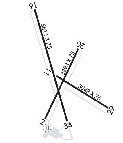
Runway Identification: 02/20Length: 3893 ft
Width: 75 ft
Surface: ASPHALT-FAIR CONDITION
Edge lights: Medium IntensityTreatment: NONE
| | Runway: 02 | | Runway: 20 |
| Mag heading: | 17° | Mag heading: | 197° |
| Rwy Slope: | .07% Up | Rwy Slope: | -.07% Down |
| Approach: | | Approach: | |
| Pattern: | Right Traffic | Pattern: | Left Traffic |
| Markings: | BASIC | Markings: | BASIC |
| Marking Condition: | GOOD | Marking Condition: | GOOD |
| Arresting Dev: | | Arresting Dev: | |
| Lat & Long: | N3219.5 W10231.9 | Lat. & Long.: | N3220.1 W10231.6 |
| Elev: | 3165.5 ft. MSL | Elev: | 3168.3 ft. MSL |
| TCH: | 26 ft. AGL | TCH: | 42 ft. AGL |
| Visual Glide Path: | 3.00 degrees | Visual Glide Path: | 3.00 degrees |
| Displaced Threshold: | 954 feet | Displaced Threshold: | No |
| Touchdown Zone: | YES | Touchdown Zone: | YES |
| Touchdown Elev.: | 3168.3 feet | Touchdown Elev.: | 3168.3 feet |
| Visual Glide Slope: | 2-Light PAPI on LEFT side of Runway | Visual Glide Slope: | 2-Light PAPI on LEFT side of Runway |
| RVR Equipment: | | RVR Equipment: | |
| RVV Equipment: | NO | RVV Equipment: | NO |
| Approach Lights: | | Approach Lights: | |
| REIL: | NO | REIL: | NO |
| Centerline Lights: | NO | Centerline Lights: | NO |
| Touchdown lights: | NO | Touchdown lights: | NO |
| Runway Category: | Runway with a Visual Approach | Runway Category: | Runway with a Visual Approach |
| Declared Distances: | | Declared Distances: | |
| Obstructions: | TREES | Obstructions: | GND |
| Marked: | NOT Marked/Lighted | Marked: | NOT Marked/Lighted |
| Clearance slope: | 1:1; RWY 02 APCH SLOPE 14:1 AT DSPLCD THR OVR 55 FT TREE, 822 FT DSTC, 205 FT L. | Clearance slope: | 31:1 |
| Obstruction height: | 55 feet AGL | Obstruction height: | 10 feet AGL |
| Dist. from runway: | 285 feet | Dist. from runway: | 514 feet |
| Centerline offset: | 138 left of centerline | Centerline offset: | 125 feet right of centerline |
| Comments: | 2 FT. POSTS/CABLE FENCE. | Comments: | |
Runway Identification: 11/29Length: 3048 ft
Width: 75 ft
Surface: ASPHALT-FAIR CONDITION
Edge lights: Treatment: NONE
| | Runway: 11 | | Runway: 29 |
| Mag heading: | 114° | Mag heading: | 294° |
| Rwy Slope: | -.27% Down | Rwy Slope: | .27% Up |
| Approach: | | Approach: | |
| Pattern: | Left Traffic | Pattern: | Right Traffic |
| Markings: | BASIC | Markings: | BASIC |
| Marking Condition: | GOOD | Marking Condition: | GOOD |
| Arresting Dev: | | Arresting Dev: | |
| Lat & Long: | N3219.9 W10231.8 | Lat. & Long.: | N3219.6 W10231.3 |
| Elev: | 3165.9 ft. MSL | Elev: | 3157.7 ft. MSL |
| TCH: | | TCH: | |
| Visual Glide Path: | | Visual Glide Path: | |
| Displaced Threshold: | No | Displaced Threshold: | No |
| Touchdown Zone: | YES | Touchdown Zone: | YES |
| Touchdown Elev.: | 3165.9 feet | Touchdown Elev.: | 3165.8 feet |
| Visual Glide Slope: | | Visual Glide Slope: | |
| RVR Equipment: | | RVR Equipment: | |
| RVV Equipment: | NO | RVV Equipment: | NO |
| Approach Lights: | | Approach Lights: | |
| REIL: | NO | REIL: | NO |
| Centerline Lights: | NO | Centerline Lights: | NO |
| Touchdown lights: | NO | Touchdown lights: | NO |
| Runway Category: | Runway with a Visual Approach | Runway Category: | Runway with a Visual Approach |
| Declared Distances: | | Declared Distances: | |
| Obstructions: | TREES | Obstructions: | POLE |
| Marked: | NOT Marked/Lighted | Marked: | NOT Marked/Lighted |
| Clearance slope: | 13:1 | Clearance slope: | 36:1 |
| Obstruction height: | 55 feet AGL | Obstruction height: | 45 feet AGL |
| Dist. from runway: | 940 feet | Dist. from runway: | 1830 feet |
| Centerline offset: | 130 right of centerline | Centerline offset: | 125 feet left of centerline |
| Comments: | | Comments: | |
Runway Identification: 16/34Length: 5816 ft
Width: 75 ft
Surface: ASPHALT
Edge lights: Medium IntensityTreatment: NONE
| | Runway: 16 | | Runway: 34 |
| Mag heading: | 155° | Mag heading: | 335° |
| Rwy Slope: | -.10% Down | Rwy Slope: | .10% Up |
| Approach: | | Approach: | |
| Pattern: | Left Traffic | Pattern: | Right Traffic |
| Markings: | NONPRECISION INSTRUMENT | Markings: | NONPRECISION INSTRUMENT |
| Marking Condition: | GOOD | Marking Condition: | GOOD |
| Arresting Dev: | | Arresting Dev: | |
| Lat & Long: | N3220.4 W10232.0 | Lat. & Long.: | N3219.5 W10231.7 |
| Elev: | 3174.0 ft. MSL | Elev: | 3167.9 ft. MSL |
| TCH: | 37 ft. AGL | TCH: | 34 ft. AGL |
| Visual Glide Path: | 3.00 degrees | Visual Glide Path: | 3.00 degrees |
| Displaced Threshold: | No | Displaced Threshold: | No |
| Touchdown Zone: | YES | Touchdown Zone: | YES |
| Touchdown Elev.: | 3174.0 feet | Touchdown Elev.: | 3167.9 feet |
| Visual Glide Slope: | 4-Light PAPI on LEFT side of Runway | Visual Glide Slope: | 4-Light PAPI on LEFT side of Runway |
| RVR Equipment: | | RVR Equipment: | |
| RVV Equipment: | NO | RVV Equipment: | NO |
| Approach Lights: | | Approach Lights: | |
| REIL: | YES | REIL: | YES |
| Centerline Lights: | NO | Centerline Lights: | NO |
| Touchdown lights: | NO | Touchdown lights: | NO |
| Runway Category: | Runway with a Non-precision Approach having visibility minimums greater than 3/4 mile | Runway Category: | Runway with a Visual Approach |
| Declared Distances: | | Declared Distances: | |
| Obstructions: | TREE | Obstructions: | TREES |
| Marked: | NOT Marked/Lighted | Marked: | NOT Marked/Lighted |
| Clearance slope: | 15:1 | Clearance slope: | 21:1 |
| Obstruction height: | 64 feet AGL | Obstruction height: | 46 feet AGL |
| Dist. from runway: | 1200 feet | Dist. from runway: | 1190 feet |
| Centerline offset: | 542 right of centerline | Centerline offset: | 126 feet right of centerline |
| Comments: | | Comments: | |
Runway Identification: H1 HELIPADLength: 25 ft
Width: 25 ft
Surface: ASPHALT-GOOD CONDITION
Edge lights:
Treatment: NONE