
| DYERSBURG RGNL DYERSBURG TN |
| |
| Lat: N 3559.9 Long: W 08924.4 Elev: 338 Var: +01 Longest Runway: 5698 | ||
| AWOS: 135.62 CTAF: 123.05 | ||
| ||||||
| ||||||
|
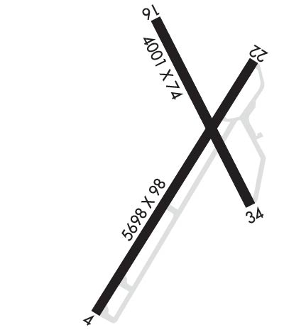
| Rwy | Rwy | |||||||
| 5698x98 | 5698' | 5698x98 | 5004' | |||||
| 4001x74 | 4001' | 4001x74 | 4001' | |||||
| Runway ID | Single Wheel | Double Wheel | Double Tandem Wheel | Dual Double Wheel |
| 04/22 | 55,000 | 80,000 | 140,000 | N/A |
| 16/34 | 50,000 | 75,000 | 135,000 | N/A |
| These numbers are Advisory and are not limits. The Airport Manager should have more accurate Weight Limits | ||||
 Airport Diagram might not be current. | |
| Facility Name: | DYERSBURG RGNL |
| City Name: | DYERSBURG |
| County: | DYER |
| State abbrev: | TN |
| State Name: | TENNESSEE |
| Ownership: | PUBLICLY OWNED |
| Use: | OPEN TO THE PUBLIC |
| Owner's Name: | CITY OF DYERSBURG |
| Address: | CITY HALL, PO BOX 1358 |
| DYERSBURG, TN 38024 | |
| Owner's Phone: | (731) 288-7600 |
| Manager's Name: | TOMMY GIBBONS |
| Address: | 315 AIRPORT ROAD |
| DYERSBURG, TN 38024 | |
| Phone: | 731-287-8181 |
| FAA Region: | SOUTHERN |
| FAA Field Office: | MEM |
| Date | Sunrise | Sunset |
|---|---|---|
| 09/24/21 Friday | 6:47 | 18:52 |
| 09/25/21 Saturday | 6:48 | 18:50 |
| 09/26/21 Sunday | 6:48 | 18:49 |
| 09/27/21 Monday | 6:49 | 18:47 |
| 09/28/21 Tuesday | 6:50 | 18:46 |
| 09/29/21 Wednesday | 6:51 | 18:44 |
| 09/30/21 Thursday | 6:52 | 18:43 |
| 10/01/21 Friday | 6:52 | 18:42 |
| 10/02/21 Saturday | 6:53 | 18:40 |
| 10/03/21 Sunday | 6:54 | 18:39 |
| 10/04/21 Monday | 6:55 | 18:37 |
| 10/05/21 Tuesday | 6:56 | 18:36 |
| 10/06/21 Wednesday | 6:57 | 18:34 |
| 10/07/21 Thursday | 6:57 | 18:33 |
| Airport Attendance Schedule | NOV-MAR 7 Days A Week 0800-1700, APR-OCT MON-FRI 0700-1900, APR-OCT SAT-SUN 0800-1700 |
| Airport Status | OPERATIONAL (This Status can change at any time - please check NOTAMS) |
| Airport Lighting Schedule | ACTVT REIL RWY 04 & 22; MIRL RWY 04/22 - CTAF. PAPI RWY 04 & 22 ON CONSLY. |
| Airport Storage Available | Tie Downs, Hanger |
| Extra Services Available | NONE |
| Wind Indicator | YES - (lighted) |
| Control Tower | NO |
| CTAF Frequency | 123.050 |
| Unicom Frequency | 123.050 |
| Rotating Beacon Color | CLEAR-GREEN (Light Land Airport) |
| Segmented Circle | YES |
| Landing Fee | NO |
| Airport Inspected | STATE - performed by STATE AERONAUTICAL PERSONNEL |
| Inspection Date | 05/08/2019 |
| Type of Fuel Available | Grade 100LL, JET A |
| Airframe Repair Service | NONE |
| Power Plant Repair Service | NONE |
| Latitude | N3559.9 |
| Longitude | W08924.4 (ESTIMATED) |
| Arpt Elevation | 337ft (SURVEYED) |
| Magnetic Variation | 01W |
| 2 miles S | of DYERSBURG |
| Traffic Pattern Altitude | |
| Sectional Chart | ST LOUIS |
| Operations (Reported) | Yearly | Avg. Daily |
|---|---|---|
| General Aviation Transient | 5000 | 14 |
| General Aviation Local | 2600 | 7 |
| Air Taxi | 80 | 0 |
| Commerical | 0 | 0 |
| Commuter | 0 | 0 |
| Military | 120 | 0 |
| Aircraft based on Field | |
|---|---|
| General Aviation Singles | 13 |
| General Aviation Multi | 5 |
| Jet Aircraft | 2 |
| General Aviation Helicopters | 0 |
| Military Aircraft | 0 |
| Gliders | 0 |
| Ultralights | 0 |
| FSS on field | NO |
| FSS tie-in | JACKSON |
| FSS Phone | 1-800-WX-BRIEF |
| Who issues Notams | DYR |
| Notam D service at airport | YES |
| ARTCC Name | MEMPHIS |
| Airport Certification | |
| Aircraft Rescue & Firefighting Index | None |
| Airport of Entry | No |
| Custom Landing Rights | No |
| Joint Civil/Military | No |
| Military Landing rights | YES |
| NATIONAL PLAN OF INTEGRATED AIRPORT SYSTEMS (NPIAS) |
| GRANT AGREEMENTS UNDER FAAP/ADAP/AIP |
| ASSURANCES PURSUANT TO TITLE VI, CIVIL RIGHTS ACT OF 1964 |
| AGREEMENT UNDER DLAND OR DCLA HAS EXPIRED. |
| FOR CD CTC MEMPHIS ARTCC AT 901-368-8453/8449. |
| RWY 16/3 4 CLSD INDEFLY. |
Airport Communications & Frequencies:
| |||||||||
| Runway: 04 | Runway: 22 | ||
| Mag heading: | 41° | Mag heading: | 222° |
| Rwy Slope: | .76% Up | Rwy Slope: | -.76% Down |
| Approach: | Approach: | ||
| Pattern: | Left Traffic | Pattern: | Left Traffic |
| Markings: | NONPRECISION INSTRUMENT | Markings: | NONPRECISION INSTRUMENT |
| Marking Condition: | GOOD | Marking Condition: | GOOD |
| Arresting Dev: | Arresting Dev: | ||
| Lat & Long: | N3559.4 W08924.8 | Lat. & Long.: | N3600.1 W08924.1 |
| Elev: | 291.5 ft. MSL | Elev: | 334.6 ft. MSL |
| TCH: | 35 ft. AGL | TCH: | 28 ft. AGL |
| Visual Glide Path: | 3.00 degrees | Visual Glide Path: | 3.00 degrees |
| Displaced Threshold: | No | Displaced Threshold: | 694 feet |
| Touchdown Zone: | YES | Touchdown Zone: | YES |
| Touchdown Elev.: | 316.1 feet | Touchdown Elev.: | 333.9 feet |
| Visual Glide Slope: | 4-Light PAPI on LEFT side of Runway | Visual Glide Slope: | 4-Light PAPI on LEFT side of Runway |
| RVR Equipment: | RVR Equipment: | ||
| RVV Equipment: | NO | RVV Equipment: | NO |
| Approach Lights: | Approach Lights: | ||
| REIL: | YES | REIL: | YES |
| Centerline Lights: | NO | Centerline Lights: | NO |
| Touchdown lights: | NO | Touchdown lights: | NO |
| Runway Category: | Runway with a Non-precision Approach having visibility minimums greater than 3/4 mile | Runway Category: | Runway with a Non-precision Approach having visibility minimums greater than 3/4 mile |
| Declared Distances: | Declared Distances: | ||
| Obstructions: | TREES | Obstructions: | TREES |
| Marked: | NOT Marked/Lighted | Marked: | NOT Marked/Lighted |
| Clearance slope: | 22:1 | Clearance slope: | 12:1 |
| Obstruction height: | 57 feet AGL | Obstruction height: | 47 feet AGL |
| Dist. from runway: | 1478 feet | Dist. from runway: | 780 feet |
| Centerline offset: | 371 left of centerline | Centerline offset: | 371 feet right of centerline |
| Comments: | Comments: |
| Runway: 16 | Runway: 34 | ||
| Mag heading: | 163° | Mag heading: | 343° |
| Rwy Slope: | -.31% Down | Rwy Slope: | .31% Up |
| Approach: | Approach: | ||
| Pattern: | Left Traffic | Pattern: | Left Traffic |
| Markings: | BASIC | Markings: | BASIC |
| Marking Condition: | FAIR | Marking Condition: | FAIR |
| Arresting Dev: | Arresting Dev: | ||
| Lat & Long: | N3600.3 W08924.4 | Lat. & Long.: | N3559.7 W08924.2 |
| Elev: | 337.7 ft. MSL | Elev: | 325.3 ft. MSL |
| TCH: | TCH: | ||
| Visual Glide Path: | Visual Glide Path: | ||
| Displaced Threshold: | No | Displaced Threshold: | No |
| Touchdown Zone: | YES | Touchdown Zone: | YES |
| Touchdown Elev.: | 337.7 feet | Touchdown Elev.: | 337.7 feet |
| Visual Glide Slope: | Visual Glide Slope: | ||
| RVR Equipment: | RVR Equipment: | ||
| RVV Equipment: | NO | RVV Equipment: | NO |
| Approach Lights: | Approach Lights: | ||
| REIL: | NO | REIL: | NO |
| Centerline Lights: | NO | Centerline Lights: | NO |
| Touchdown lights: | NO | Touchdown lights: | NO |
| Runway Category: | Runway with a Visual Approach | Runway Category: | Runway with a Visual Approach |
| Declared Distances: | Declared Distances: | ||
| Obstructions: | TREE | Obstructions: | TREE |
| Marked: | NOT Marked/Lighted | Marked: | NOT Marked/Lighted |
| Clearance slope: | 27:1 | Clearance slope: | 7:1 |
| Obstruction height: | 27 feet AGL | Obstruction height: | 78 feet AGL |
| Dist. from runway: | 947 feet | Dist. from runway: | 816 feet |
| Centerline offset: | 292 left of centerline | Centerline offset: | 355 feet left of centerline |
| Comments: | Comments: |
Thanks for using FltPlan.com
all rights reserved © 1999-2021 by Flight Plan LLC
