
| DANBURY MUNI DANBURY CT |
| |
| Lat: N 4122.3 Long: W 07328.9 Elev: 457 Var: +14 Longest Runway: 4421 | ||
| Clr Del: 128.6 TW CLSD Dept. ATIS: 127.75 Arr. ATIS: 127.75 AWOS: 127.75 Ground: 121.6 Tower: 119.4 | ||
| |||||||||||||||||||||||||||||||||||||||||||||||||||||||||||||||||||||
| |||||||||||||||||||||||||||||||||||||||||||||||||||||||||||||||||||||
| |||||||||||||||||||||||||||||||||||||||||||||||||||||||||||||||||||||
| |||||||||||||||||||||||||||||||||||||||||||||||||||||||||||||||||||||
| |||||||||||||||||||||||||||||||||||||||||||||||||||||||||||||||||||||
| |||||||||||||||||||||||||||||||||||||||||||||||||||||||||||||||||||||
| |||||||||||||||||||||||||||||||||||||||||||||||||||||||||||||||||||||
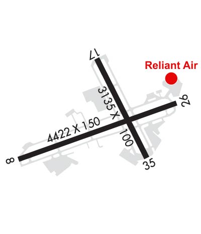
| Rwy | Rwy | |||||||
| 4421x150 | 4054' | 111.55 - 087° | 4421x150 | 3687' | ||||
| 3135x100 | 2912' | 3135x100 | 2904' | |||||
| Runway ID | Single Wheel | Double Wheel | Double Tandem Wheel | Dual Double Wheel |
| 08/26 | 38,000 | 70,000 | N/A | N/A |
| 17/35 | 50,000 | 65,000 | N/A | N/A |
| These numbers are Advisory and are not limits. The Airport Manager should have more accurate Weight Limits | ||||
 Airport Diagram might not be current. | |
| Facility Name: | DANBURY MUNI |
| City Name: | DANBURY |
| County: | FAIRFIELD |
| State abbrev: | CT |
| State Name: | CONNECTICUT |
| Ownership: | PUBLICLY OWNED |
| Use: | OPEN TO THE PUBLIC |
| Owner's Name: | CITY OF DANBURY |
| Address: | CITY HALL, 115 DEER HILL DR. |
| DANBURY, CT 06810 | |
| Owner's Phone: | 203-797-4624 |
| Manager's Name: | MICHAEL SAFRANEK |
| Address: | P.O.BOX 2299 |
| DANBURY, CT 06813 | |
| Phone: | 203-797-4624 |
| FAA Region: | NEW ENGLAND |
| FAA Field Office: | NONE |
| Date | Sunrise | Sunset |
|---|---|---|
| 06/08/26 Monday | 5:21 | 20:25 |
| 06/09/26 Tuesday | 5:20 | 20:26 |
| 06/10/26 Wednesday | 5:20 | 20:27 |
| 06/11/26 Thursday | 5:20 | 20:27 |
| 06/12/26 Friday | 5:20 | 20:28 |
| 06/13/26 Saturday | 5:20 | 20:28 |
| 06/14/26 Sunday | 5:20 | 20:29 |
| 06/15/26 Monday | 5:20 | 20:29 |
| 06/16/26 Tuesday | 5:20 | 20:29 |
| 06/17/26 Wednesday | 5:20 | 20:30 |
| 06/18/26 Thursday | 5:20 | 20:30 |
| 06/19/26 Friday | 5:20 | 20:30 |
| 06/20/26 Saturday | 5:20 | 20:31 |
| 06/21/26 Sunday | 5:21 | 20:31 |
| Airport Attendance Schedule | 7 Days A Week 0700-DUSK |
| Airport Status | OPERATIONAL (This Status can change at any time - please check NOTAMS) |
| Airport Lighting Schedule | WHEN ATCT CLSD, ACTVT REIL RWY 08 & 26; MIRL RWY 08/26 - CTAF. |
| Airport Storage Available | Tie Downs, Hanger |
| Extra Services Available | Air Freight, Avionics, Charter, Flight Instruction, Aircraft Rental, Aircraft Sales, Annual Surveying |
| Wind Indicator | YES - (lighted) |
| Control Tower | YES |
| CTAF Frequency | 119.400 |
| Unicom Frequency | 122.950 |
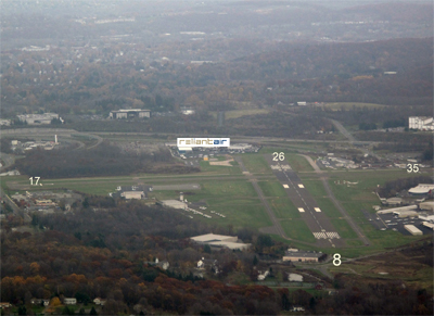
| Rotating Beacon Color | WG; ROTG BCN LCTD ONE MILE SOUTH OF ARPT ON TOP OF A HILL. |
| Segmented Circle | YES |
| Landing Fee | NO |
| Airport Inspected | STATE - performed by PRIVATE CONTRACT PERSONNEL |
| Inspection Date | 08/22/2022 |
| Type of Fuel Available | Grade 100LL, JET A (freeze point -40C) |
| Airframe Repair Service | MAJOR |
| Power Plant Repair Service | MAJOR |
| Latitude | N4122.3 |
| Longitude | W07328.9 (ESTIMATED) |
| Arpt Elevation | 456ft (SURVEYED) |
| Magnetic Variation | 14W |
| 3 miles SW | of DANBURY |
| Traffic Pattern Altitude | 1243; 1743 FT AGL TURBOPROP/JET. |
| Sectional Chart | NEW YORK |
| Operations (Reported) | Yearly | Avg. Daily |
|---|---|---|
| General Aviation Transient | 0 | 0 |
| General Aviation Local | 0 | 0 |
| Air Taxi | 0 | 0 |
| Commerical | 0 | 0 |
| Commuter | 0 | 0 |
| Military | 0 | 0 |
| Aircraft based on Field | |
|---|---|
| General Aviation Singles | 0 |
| General Aviation Multi | 0 |
| Jet Aircraft | 0 |
| General Aviation Helicopters | 0 |
| Military Aircraft | 0 |
| Gliders | 0 |
| Ultralights | 0 |
| FSS on field | NO |
| FSS tie-in | BRIDGEPORT |
| FSS Phone | 1-800-WX-BRIEF |
| Who issues Notams | DXR |
| Notam D service at airport | YES |
| ARTCC Name | NEW YORK |
| Airport Certification | |
| Aircraft Rescue & Firefighting Index | None |
| Airport of Entry | No |
| Custom Landing Rights | No |
| Joint Civil/Military | No |
| Military Landing rights | YES |
| NATIONAL PLAN OF INTEGRATED AIRPORT SYSTEMS (NPIAS) |
| GRANT AGREEMENTS UNDER FAAP/ADAP/AIP |
| ASSURANCES PURSUANT TO TITLE VI, CIVIL RIGHTS ACT OF 1964 |
| AGREEMENT UNDER DLAND OR DCLA HAS EXPIRED. |
| ACFT USING RWY 35 ARE NOT VSB FM TWR DESCENDING BLW 1300 FT ON BASE LEG TIL APCHG 1/2 MI FINAL DUE TO NATURAL TRRN. |
| PROHIBITED TO ULTRALIGHT & UNREGISTERED ACFT. |
| COND UNMNT 1630-0730 MON-FRI & WKENDS. |
| DEER & BIRDS ON & INVOF ARPT. |
| INTXN TKOFS, STOP & GO TKOFS NOT AUZD. |
| PPR FOR FRMN TKOF/LDG; CTC AMGR. |
| NOISE ABATEMENT PROCS IN EFCT, RWY 17, SR-SS. DEPG RWY 17, EXTD RWY HDG BYD LAKE WAUBEEKA COMMUNITY BFR TURNING CROSSWIND. |
| RWY 17/3 5 RWY CLSD NGTS. |
Airport Communications & Frequencies:
| ||||||||||||||||||||||
| Runway: 08 | Runway: 26 | ||
| Mag heading: | 84° | Mag heading: | 264° |
| Rwy Slope: | -.08% Down | Rwy Slope: | .08% Up |
| Approach: | LOC/DME | Approach: | |
| Pattern: | Left Traffic | Pattern: | Left Traffic |
| Markings: | NONPRECISION INSTRUMENT | Markings: | NONPRECISION INSTRUMENT |
| Marking Condition: | GOOD | Marking Condition: | GOOD |
| Arresting Dev: | Arresting Dev: | ||
| Lat & Long: | N4122.1 W07329.4 | Lat. & Long.: | N4122.4 W07328.5 |
| Elev: | 456.6 ft. MSL | Elev: | 453.1 ft. MSL |
| TCH: | TCH: | ||
| Visual Glide Path: | Visual Glide Path: | ||
| Displaced Threshold: | 367 feet | Displaced Threshold: | 734 feet |
| Touchdown Zone: | YES | Touchdown Zone: | YES |
| Touchdown Elev.: | 456.6 feet | Touchdown Elev.: | 456.4 feet |
| Visual Glide Slope: | Visual Glide Slope: | ||
| RVR Equipment: | RVR Equipment: | ||
| RVV Equipment: | NO | RVV Equipment: | NO |
| Approach Lights: | Approach Lights: | ||
| REIL: | YES | REIL: | YES |
| Centerline Lights: | NO | Centerline Lights: | NO |
| Touchdown lights: | NO | Touchdown lights: | NO |
| Runway Category: | Runway with a Non-precision Approach | Runway Category: | Runway with a Non-precision Approach |
| Declared Distances: | Declared Distances: | ||
| Obstructions: | TREES | Obstructions: | TREES |
| Marked: | NOT Marked/Lighted | Marked: | NOT Marked/Lighted |
| Clearance slope: | 2:1; APCH RATIO 12:1 BASED ON DSPLCD THR. | Clearance slope: | 3:1; APCH RATIO 11:1 TO DSPLCD THR. |
| Obstruction height: | 15 feet AGL | Obstruction height: | 88 feet AGL |
| Dist. from runway: | 230 feet | Dist. from runway: | 450 feet |
| Centerline offset: | 75 left of centerline | Centerline offset: | 100 feet right of centerline |
| Comments: | +9 FT FENCE 170 FT FM THR. | Comments: | +6 FT FENCE 75 FT FM THR. |
| Runway: 17 | Runway: 35 | ||
| Mag heading: | 167° | Mag heading: | 347° |
| Rwy Slope: | .06% Up | Rwy Slope: | -.06% Down |
| Approach: | Approach: | ||
| Pattern: | Left Traffic | Pattern: | Left Traffic |
| Markings: | BASIC | Markings: | BASIC |
| Marking Condition: | GOOD | Marking Condition: | GOOD |
| Arresting Dev: | Arresting Dev: | ||
| Lat & Long: | N4122.6 W07329.0 | Lat. & Long.: | N4122.1 W07328.7 |
| Elev: | 451.5 ft. MSL | Elev: | 453.3 ft. MSL |
| TCH: | TCH: | ||
| Visual Glide Path: | Visual Glide Path: | ||
| Displaced Threshold: | 223 feet | Displaced Threshold: | 231 feet |
| Touchdown Zone: | YES | Touchdown Zone: | YES |
| Touchdown Elev.: | 453.5 feet | Touchdown Elev.: | 453.5 feet |
| Visual Glide Slope: | Visual Glide Slope: | ||
| RVR Equipment: | RVR Equipment: | ||
| RVV Equipment: | NO | RVV Equipment: | NO |
| Approach Lights: | Approach Lights: | ||
| REIL: | NO | REIL: | NO |
| Centerline Lights: | NO | Centerline Lights: | NO |
| Touchdown lights: | NO | Touchdown lights: | NO |
| Runway Category: | Runway with a Visual Approach | Runway Category: | Runway with a Visual Approach |
| Declared Distances: | Declared Distances: | ||
| Obstructions: | POLE | Obstructions: | TREES |
| Marked: | NOT Marked/Lighted | Marked: | NOT Marked/Lighted |
| Clearance slope: | 18:1; APCH RATIO 28:1 TO DSPLCD THR. | Clearance slope: | 5:1; APCH RATIO 19:1 TO DSPLCD THR. |
| Obstruction height: | 22 feet AGL | Obstruction height: | 30 feet AGL |
| Dist. from runway: | 600 feet | Dist. from runway: | 350 feet |
| Centerline offset: | 150 left of centerline | Centerline offset: | 100 feet right of centerline |
| Comments: | 5 FT FENCE 50 FT FM THR; +15 FT ROAD 94 FT FM THR. | Comments: | +8 FT FENCE 150 FT FM THR; +17 FT ROAD 120 FT FM THR. |
Thanks for using FltPlan.com
all rights reserved © 1999-2026 by Flight Plan LLC