Runway Identification: 17L/35RLength: 3500 ft
Width: 35 ft
Surface: ASPHALT-GOOD CONDITION
Edge lights: Treatment: NONE
| | Runway: 17L | | Runway: 35R |
| Mag heading: | 168° | Mag heading: | 348° |
| Rwy Slope: | -.18% Down | Rwy Slope: | .18% Up |
| Approach: | | Approach: | |
| Pattern: | Left Traffic | Pattern: | Right Traffic |
| Markings: | BASIC | Markings: | BASIC |
| Marking Condition: | GOOD | Marking Condition: | GOOD |
| Arresting Dev: | | Arresting Dev: | |
| Lat & Long: | N3003.8 W09533.1 | Lat. & Long.: | N3003.2 W09533.1 |
| Elev: | 149.9 ft. MSL | Elev: | 143.7 ft. MSL |
| TCH: | | TCH: | |
| Visual Glide Path: | | Visual Glide Path: | |
| Displaced Threshold: | No | Displaced Threshold: | 208 feet |
| Touchdown Zone: | YES | Touchdown Zone: | YES |
| Touchdown Elev.: | 149.9 feet | Touchdown Elev.: | 148.0 feet |
| Visual Glide Slope: | | Visual Glide Slope: | |
| RVR Equipment: | | RVR Equipment: | |
| RVV Equipment: | NO | RVV Equipment: | NO |
| Approach Lights: | | Approach Lights: | |
| REIL: | NO | REIL: | NO |
| Centerline Lights: | NO | Centerline Lights: | NO |
| Touchdown lights: | NO | Touchdown lights: | NO |
| Runway Category: | Runway with a Visual Approach | Runway Category: | Runway with a Visual Approach |
| Declared Distances: | | Declared Distances: | |
| Obstructions: | | Obstructions: | TREES |
| Marked: | | Marked: | LIGHTED |
| Clearance slope: | 50:1 | Clearance slope: | 1:1; OBSTN CLNC SLOPE 7:1 AT DSPLCD THLD. |
| Obstruction height: | | Obstruction height: | 60 feet AGL |
| Dist. from runway: | | Dist. from runway: | 300 feet |
| Centerline offset: | | Centerline offset: | 110 feet left of centerline |
| Comments: | | Comments: | |
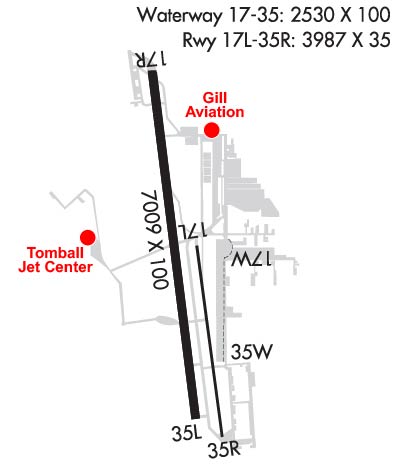
Runway Identification: 17R/35LLength: 7009 ft
Width: 100 ft
Surface: ASPHALT-GOOD CONDITION
Edge lights: High IntensityTreatment: NONE
| | Runway: 17R | | Runway: 35L |
| Mag heading: | 168° | Mag heading: | 348° |
| Rwy Slope: | -.07% Down | Rwy Slope: | .07% Up |
| Approach: | LOC/DME | Approach: | |
| Pattern: | Left Traffic | Pattern: | Left Traffic |
| Markings: | NONPRECISION INSTRUMENT | Markings: | NONPRECISION INSTRUMENT |
| Marking Condition: | GOOD | Marking Condition: | GOOD |
| Arresting Dev: | | Arresting Dev: | |
| Lat & Long: | N3004.4 W09533.3 | Lat. & Long.: | N3003.3 W09533.1 |
| Elev: | 150.5 ft. MSL | Elev: | 145.3 ft. MSL |
| TCH: | 52 ft. AGL | TCH: | 41 ft. AGL |
| Visual Glide Path: | 3.00 degrees | Visual Glide Path: | 3.00 degrees |
| Displaced Threshold: | 1007 feet | Displaced Threshold: | No |
| Touchdown Zone: | YES | Touchdown Zone: | YES |
| Touchdown Elev.: | 152.4 feet | Touchdown Elev.: | 151.7 feet |
| Visual Glide Slope: | 4-Light PAPI on RIGHT side of Runway | Visual Glide Slope: | 4-Light PAPI on LEFT side of Runway |
| RVR Equipment: | | RVR Equipment: | |
| RVV Equipment: | NO | RVV Equipment: | NO |
| Approach Lights: | | Approach Lights: | |
| REIL: | YES; REIL LCTD 126 FT BYD DSPLCD THR. | REIL: | YES |
| Centerline Lights: | NO | Centerline Lights: | NO |
| Touchdown lights: | NO | Touchdown lights: | NO |
| Runway Category: | Runway with a Non-precision Approach having visibility minimums greater than 3/4 mile | Runway Category: | Runway with a Non-precision Approach having visibility minimums greater than 3/4 mile |
| Declared Distances: | TORA:7009' TODA:7009' ASDA:7009' LDA:6002' | Declared Distances: | TORA:6700' TODA:6700' ASDA:6700' LDA:6700' |
| Obstructions: | ROAD | Obstructions: | TREES |
| Marked: | NOT Marked/Lighted | Marked: | NOT Marked/Lighted |
| Clearance slope: | APCH RATIO 26:1 AT DSPLCD THR OVR 100 FT TREES 2600 FT DSTC. | Clearance slope: | 1:1 |
| Obstruction height: | 15 feet AGL | Obstruction height: | 60 feet AGL |
| Dist. from runway: | 200 feet | Dist. from runway: | 300 feet |
| Centerline offset: | 160 left of centerline | Centerline offset: | 260 feet left of centerline |
| Comments: | 8 FT FENCE, 0 FT DSTC, 240 L, 15 FT RD, 145 FT DSTC, 238 FT L. | Comments: | |
Runway Identification: 17W/35WLength: 2530 ft
Width: 100 ft
Surface: WATER-GOOD CONDITION
Edge lights: Treatment: NONE
| | Runway: 17W | | Runway: 35W |
| Mag heading: | N/A | Mag heading: | N/A |
| Rwy Slope: | .00% | Rwy Slope: | .00% |
| Approach: | | Approach: | |
| Pattern: | Left Traffic | Pattern: | Right Traffic |
| Markings: | NONE | Markings: | NONE |
| Marking Condition: | GOOD; BUOY | Marking Condition: | GOOD; BUOY |
| Arresting Dev: | | Arresting Dev: | |
| Lat & Long: | N3003.9 W09533.1 | Lat. & Long.: | N3003.4 W09533.1 |
| Elev: | 138.0 ft. MSL | Elev: | 138.0 ft. MSL |
| TCH: | | TCH: | |
| Visual Glide Path: | | Visual Glide Path: | |
| Displaced Threshold: | No | Displaced Threshold: | No |
| Touchdown Zone: | YES | Touchdown Zone: | YES |
| Touchdown Elev.: | 138.0 feet | Touchdown Elev.: | 138.0 feet |
| Visual Glide Slope: | | Visual Glide Slope: | |
| RVR Equipment: | | RVR Equipment: | |
| RVV Equipment: | NO | RVV Equipment: | NO |
| Approach Lights: | | Approach Lights: | |
| REIL: | NO | REIL: | NO |
| Centerline Lights: | NO | Centerline Lights: | NO |
| Touchdown lights: | NO | Touchdown lights: | NO |
| Runway Category: | Runway with a Visual Approach | Runway Category: | Runway with a Visual Approach |
| Declared Distances: | | Declared Distances: | |
| Obstructions: | BERM; ALSO 25 FT HGRS, 185 FT DSTC, 135 FT L, 7:1. | Obstructions: | BERM |
| Marked: | NOT Marked/Lighted | Marked: | NOT Marked/Lighted |
| Clearance slope: | | Clearance slope: | |
| Obstruction height: | 10 feet AGL | Obstruction height: | 4 feet AGL |
| Dist. from runway: | 0 feet | Dist. from runway: | 0 feet |
| Centerline offset: | | Centerline offset: | |
| Comments: | | Comments: | |
Runway Identification: H1 HELIPADLength: 50 ft
Width: 50 ft
Surface: ASPHALT-FAIR CONDITION
Edge lights:
Treatment: NONE
Runway Identification: H2 HELIPADLength: 50 ft
Width: 50 ft
Surface: ASPHALT-FAIR CONDITION
Edge lights:
Treatment: NONE
Runway Identification: H3 HELIPADLength: 50 ft
Width: 50 ft
Surface: ASPHALT-FAIR CONDITION
Edge lights:
Treatment: NONE
Runway Identification: H4 HELIPADLength: 50 ft
Width: 50 ft
Surface: ASPHALT-FAIR CONDITION
Edge lights:
Treatment: NONE