
| PHOENIX DEER VALLEY PHOENIX AZ |
| |
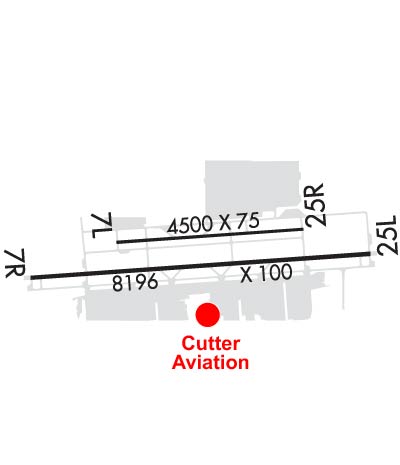
| Lat: N 3341.3 Long: W 11205.0 Elev: 1478 Var: -12 Longest Runway: 8196 | ||
| Clr Del: 123.9 Dept. ATIS: 126.5 Arr. ATIS: 126.5 Ground: 121.8 Tower: 118.4 | ||

| |||||||||||||||||||||||||||||||||||||||||||||||||||||||||||||||||||||
| |||||||||||||||||||||||||||||||||||||||||||||||||||||||||||||||||||||
| |||||||||||||||||||||||||||||||||||||||||||||||||||||||||||||||||||||
| |||||||||||||||||||||||||||||||||||||||||||||||||||||||||||||||||||||
| FBOs at nearby airports who want your business: | |||||||||||||||||
| |||||||||||||||||
| Rwy | Rwy | |||||||
| 4500x75 | 4500' | 4500x75 | 4500' | |||||
| 8196x100 | 7298' | 8196x100 | 7280' | |||||
| Runway ID | Single Wheel | Double Wheel | Double Tandem Wheel | Dual Double Wheel |
| 07L/25R | 70,000 | 117,000 | N/A | N/A |
| 07R/25L | 20,000 | 91,000 | 255,000 | N/A |
| These numbers are Advisory and are not limits. The Airport Manager should have more accurate Weight Limits | ||||
 Airport Diagram might not be current. | |
| Facility Name: | PHOENIX DEER VALLEY |
| City Name: | PHOENIX |
| County: | MARICOPA |
| State abbrev: | AZ |
| State Name: | ARIZONA |
| Ownership: | PUBLICLY OWNED |
| Use: | OPEN TO THE PUBLIC |
| Owner's Name: | CITY OF PHOENIX |
| Address: | 3400 SKY HARBOR BLVD |
| PHOENIX, AZ 85034 | |
| Owner's Phone: | 623-869-0975 |
| Manager's Name: | ED FARON |
| Address: | 702 W DEER VALLEY DR |
| PHOENIX, AZ 85027 | |
| Phone: | 623-869-0975; EMERGENCY CONTACT: 623-869-0977 (AIRPORT OPS.) |
| FAA Region: | WESTERN-PACIFIC |
| FAA Field Office: | PHX |
| Date | Sunrise | Sunset |
|---|---|---|
| 09/24/21 Friday | 6:18 | 18:22 |
| 09/25/21 Saturday | 6:18 | 18:21 |
| 09/26/21 Sunday | 6:19 | 18:20 |
| 09/27/21 Monday | 6:20 | 18:18 |
| 09/28/21 Tuesday | 6:20 | 18:17 |
| 09/29/21 Wednesday | 6:21 | 18:16 |
| 09/30/21 Thursday | 6:22 | 18:14 |
| 10/01/21 Friday | 6:23 | 18:13 |
| 10/02/21 Saturday | 6:23 | 18:12 |
| 10/03/21 Sunday | 6:24 | 18:10 |
| 10/04/21 Monday | 6:25 | 18:09 |
| 10/05/21 Tuesday | 6:25 | 18:08 |
| 10/06/21 Wednesday | 6:26 | 18:06 |
| 10/07/21 Thursday | 6:27 | 18:05 |
| Airport Attendance Schedule | CONTINUOUS; AIRPORT ADMINISTRATION HOURS: 0600-2100. |
| Airport Status | OPERATIONAL (This Status can change at any time - please check NOTAMS) |
| Airport Lighting Schedule | MIRL RWY 07R/25L & 07L/25R, PAPI RWY 07L/25R & 07R/25L & REIL RWY 07L/25R & 07R/25L ON WHEN ATCT CLOSED. |
| Airport Storage Available | Tie Downs, Hanger |
| Extra Services Available | Air Ambulance, Avionics, Charter, Flight Instruction, Aircraft Rental, Aircraft Sales |
| Wind Indicator | YES - (lighted) |
| Control Tower | YES |
| CTAF Frequency | 118.400 |
| Unicom Frequency | 122.950 |
| Rotating Beacon Color | CLEAR-GREEN (Light Land Airport) |
| Segmented Circle | YES |
| Landing Fee | NO |
| Airport Inspected | STATE - performed by PRIVATE CONTRACT PERSONNEL |
| Inspection Date | 04/14/2021 |
| Type of Fuel Available | Grade 100LL, JET A; -10FUEL AVBL 24 HR SELF SERVICE-100 LL ONLY WITH MAJOR CREDIT CARD. |
| Airframe Repair Service | MAJOR |
| Power Plant Repair Service | MAJOR |
| Latitude | N3341.3 |
| Longitude | W11205.0 (ESTIMATED) |
| Arpt Elevation | 1478ft (SURVEYED) |
| Magnetic Variation | 12E |
| 15 miles N | of PHOENIX |
| Traffic Pattern Altitude | TPA - SINGLE ENGINE (1022) MULTI ENGINE (1522). |
| Sectional Chart | PHOENIX |
| Operations (Reported) | Yearly | Avg. Daily |
|---|---|---|
| General Aviation Transient | 258263 | 708 |
| General Aviation Local | 139066 | 381 |
| Air Taxi | 4963 | 14 |
| Commerical | 10 | 0 |
| Commuter | 0 | 0 |
| Military | 142 | 0 |
| Aircraft based on Field | |
|---|---|
| General Aviation Singles | 776 |
| General Aviation Multi | 92 |
| Jet Aircraft | 19 |
| General Aviation Helicopters | 16 |
| Military Aircraft | 2 |
| Gliders | 10 |
| Ultralights | 2 |
| FSS on field | NO |
| FSS tie-in | PRESCOTT |
| FSS Phone | 1-800-WX-BRIEF |
| Who issues Notams | DVT |
| Notam D service at airport | YES |
| ARTCC Name | ALBUQUERQUE |
| Airport Certification | |
| Aircraft Rescue & Firefighting Index | None |
| Airport of Entry | No |
| Custom Landing Rights | No |
| Joint Civil/Military | No |
| Military Landing rights | YES |
| NATIONAL PLAN OF INTEGRATED AIRPORT SYSTEMS (NPIAS) |
| GRANT AGREEMENTS UNDER FAAP/ADAP/AIP |
| ASSURANCES PURSUANT TO TITLE VI, CIVIL RIGHTS ACT OF 1964 |
| LGTD HILLS NE, E, SE AND W. |
| INTENSIVE PILOT TRAINING AREA, EXERCISE EXTREME VIGILANCE WITHIN 20 NM. |
| SPECIAL AIR TRAFFIC RULE (SATR) IN EFFECT WEST OF AIRPORT CHECK SECTIONAL/TAC. |
| AEROBATIC PRACTICE AREA APPROXIMATELY 8.5 MILES NW OF DVT AIRPORT FROM SURFACE TO 6000 MSL. |
| RWY 7L-25R IS DESIGNATED TRAINING RWY. |
| TWY D1 AND D13 RUNUP PADS CLSD TO ACFT WINGSPAN MORE THAN 49 FT. |
| FOR CD WHEN ATCT CLSD, CTC PHOENIX APCH AT 602-306-2565. |
| FEE FOR ALL CHARTERS; TRAVEL CLUBS AND CERTAIN REVENUE PRODUCING ACFT. |
| BIRDS & WILDLIFE ON & INVOF ARPT. |
| HOT AIR BALLOON OPNS N, NE & NW OF ARPT. |
| RWY 07R/ 25LHAS A 140 FT STOPWAY EAST END & 154 FT STOPWAY WEST END. |
Airport Communications & Frequencies:
| |||||||||||||||||||||||||||
| Runway: 07L | Runway: 25R | ||
| Mag heading: | 74° | Mag heading: | 254° |
| Rwy Slope: | .48% Up | Rwy Slope: | -.48% Down |
| Approach: | Approach: | ||
| Pattern: | Left Traffic | Pattern: | Right Traffic |
| Markings: | NONPRECISION INSTRUMENT | Markings: | NONPRECISION INSTRUMENT |
| Marking Condition: | GOOD | Marking Condition: | GOOD |
| Arresting Dev: | Arresting Dev: | ||
| Lat & Long: | N3341.3 W11205.4 | Lat. & Long.: | N3341.4 W11204.5 |
| Elev: | 1455.1 ft. MSL | Elev: | 1476.8 ft. MSL |
| TCH: | 51 ft. AGL | TCH: | 48 ft. AGL |
| Visual Glide Path: | 3.50 degrees | Visual Glide Path: | 4.00 degrees |
| Displaced Threshold: | No | Displaced Threshold: | No |
| Touchdown Zone: | YES | Touchdown Zone: | YES |
| Touchdown Elev.: | 1469.7 feet | Touchdown Elev.: | 1476.9 feet |
| Visual Glide Slope: | 2-Light PAPI on LEFT side of Runway | Visual Glide Slope: | 2-Light PAPI on LEFT side of Runway |
| RVR Equipment: | RVR Equipment: | ||
| RVV Equipment: | NO | RVV Equipment: | NO |
| Approach Lights: | Approach Lights: | ||
| REIL: | YES | REIL: | YES |
| Centerline Lights: | NO | Centerline Lights: | NO |
| Touchdown lights: | NO | Touchdown lights: | NO |
| Runway Category: | Runway with a Visual Approach | Runway Category: | Runway with a Visual Approach |
| Declared Distances: | Declared Distances: | ||
| Obstructions: | Obstructions: | HILL | |
| Marked: | Marked: | LIGHTED | |
| Clearance slope: | 20:1 | Clearance slope: | 19:1 |
| Obstruction height: | Obstruction height: | 180 feet AGL | |
| Dist. from runway: | Dist. from runway: | 3732 feet | |
| Centerline offset: | Centerline offset: | 122 feet left of centerline | |
| Comments: | Comments: |
| Runway: 07R | Runway: 25L | ||
| Mag heading: | 74° | Mag heading: | 254° |
| Rwy Slope: | .47% Up | Rwy Slope: | -.47% Down |
| Approach: | Approach: | ||
| Pattern: | Right Traffic | Pattern: | Left Traffic |
| Markings: | NONPRECISION INSTRUMENT | Markings: | NONPRECISION INSTRUMENT |
| Marking Condition: | GOOD | Marking Condition: | GOOD |
| Arresting Dev: | Arresting Dev: | ||
| Lat & Long: | N3341.2 W11205.8 | Lat. & Long.: | N3341.3 W11204.2 |
| Elev: | 1439.9 ft. MSL | Elev: | 1478.1 ft. MSL |
| TCH: | 42 ft. AGL | TCH: | 38 ft. AGL |
| Visual Glide Path: | 3.00 degrees | Visual Glide Path: | 3.00 degrees |
| Displaced Threshold: | 898 feet | Displaced Threshold: | 916 feet |
| Touchdown Zone: | YES | Touchdown Zone: | YES |
| Touchdown Elev.: | 1460.2 feet | Touchdown Elev.: | 1475.3 feet |
| Visual Glide Slope: | 2-Light PAPI on LEFT side of Runway | Visual Glide Slope: | 2-Light PAPI on LEFT side of Runway |
| RVR Equipment: | RVR Equipment: | ||
| RVV Equipment: | NO | RVV Equipment: | NO |
| Approach Lights: | Approach Lights: | ||
| REIL: | YES | REIL: | YES |
| Centerline Lights: | NO | Centerline Lights: | NO |
| Touchdown lights: | NO | Touchdown lights: | NO |
| Runway Category: | Runway with a Non-precision Approach having visibility minimums greater than 3/4 mile | Runway Category: | Runway with a Non-precision Approach having visibility minimums greater than 3/4 mile |
| Declared Distances: | TORA:8196' TODA:8196' ASDA:8196' LDA:7299' | Declared Distances: | TORA:8196' TODA:8196' ASDA:8196' LDA:7281' |
| Obstructions: | SIGN | Obstructions: | HILL |
| Marked: | NOT Marked/Lighted | Marked: | NOT Marked/Lighted |
| Clearance slope: | 27:1; APCH SLOPE 50:1 AT DSPLCD THLD. | Clearance slope: | 30:1; APCH SLOPE 50:1 AT DSPLCD THLD. |
| Obstruction height: | 38 feet AGL | Obstruction height: | 76 feet AGL |
| Dist. from runway: | 1257 feet | Dist. from runway: | 2527 feet |
| Centerline offset: | 359 right of centerline | Centerline offset: | 565 feet left of centerline |
| Comments: | Comments: |
Thanks for using FltPlan.com
all rights reserved © 1999-2021 by Flight Plan LLC