
| EAKER FIELD DURANT OK |
| |
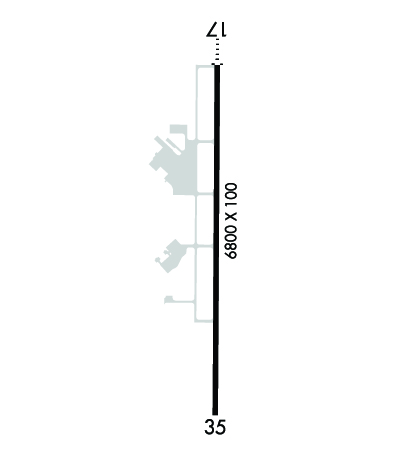
| Lat: N 3356.4 Long: W 09623.7 Elev: 699 Var: -05 Longest Runway: 6800 | ||
| AWOS: 124.17 CTAF: 122.8 | ||
| ||||||||||||||||||||||||||||||||||||||||||||
| ||||||||||||||||||||||||||||||||||||||||||||
| ||||||||||||||||||||||||||||||||||||||||||||
| Rwy | Rwy | |||||||
| 6800x100 | 6800' | 6800x100 | 6800' | |||||
| Runway ID | Single Wheel | Double Wheel | Double Tandem Wheel | Dual Double Wheel |
| 17/35 | 35,000 | 50,000 | N/A | N/A |
| These numbers are Advisory and are not limits. The Airport Manager should have more accurate Weight Limits | ||||
 Airport Diagram might not be current. | |
| Facility Name: | DURANT RGNL - EAKER FLD |
| City Name: | DURANT |
| County: | BRYAN |
| State abbrev: | OK |
| State Name: | OKLAHOMA |
| Ownership: | PUBLICLY OWNED |
| Use: | OPEN TO THE PUBLIC |
| Owner's Name: | CITY OF DURANT |
| Address: | 301 W EVERGREEN |
| DURANT, OK 74701 | |
| Owner's Phone: | (580) 920-0574 |
| Manager's Name: | JOHN WYATT |
| Address: | 10 WALDRON DR |
| DURANT, OK 74701 | |
| Phone: | 580-920-0574; AFTER HRS CALL 580-579-5024. |
| FAA Region: | SOUTHWEST |
| FAA Field Office: | AOK |
| Date | Sunrise | Sunset |
|---|---|---|
| 09/24/21 Friday | 7:15 | 19:20 |
| 09/25/21 Saturday | 7:16 | 19:18 |
| 09/26/21 Sunday | 7:16 | 19:17 |
| 09/27/21 Monday | 7:17 | 19:16 |
| 09/28/21 Tuesday | 7:18 | 19:14 |
| 09/29/21 Wednesday | 7:18 | 19:13 |
| 09/30/21 Thursday | 7:19 | 19:11 |
| 10/01/21 Friday | 7:20 | 19:10 |
| 10/02/21 Saturday | 7:21 | 19:09 |
| 10/03/21 Sunday | 7:21 | 19:07 |
| 10/04/21 Monday | 7:22 | 19:06 |
| 10/05/21 Tuesday | 7:23 | 19:05 |
| 10/06/21 Wednesday | 7:24 | 19:03 |
| 10/07/21 Thursday | 7:24 | 19:02 |
| Airport Attendance Schedule | MON-FRI 0800-1700, SAT-SUN 0900-1700 |
| Airport Status | OPERATIONAL (This Status can change at any time - please check NOTAMS) |
| Airport Lighting Schedule | ACTVT ODALS RWY 17; MIRL RWY 17/35; TWY LGTS - CTAF. PAPI RWY 17 & 35 OPR CONSLY. |
| Airport Storage Available | Tie Downs |
| Extra Services Available | Flight Instruction, Aircraft Rental, Aircraft Sales |
| Wind Indicator | YES - (lighted) |
| Control Tower | NO |
| CTAF Frequency | 122.800 |
| Unicom Frequency | 122.800 |
| Rotating Beacon Color | CLEAR-GREEN (Light Land Airport) |
| Segmented Circle | YES |
| Landing Fee | NO |
| Airport Inspected | STATE - performed by STATE AERONAUTICAL PERSONNEL |
| Inspection Date | 07/18/2018 |
| Type of Fuel Available | Grade 100LL, JET A (freeze point -40C); -10FOR FUEL AFT HRS CALL 580-579-5024. |
| Airframe Repair Service | MAJOR |
| Power Plant Repair Service | MAJOR |
| Latitude | N3356.4 |
| Longitude | W09623.7 (ESTIMATED) |
| Arpt Elevation | 699ft (SURVEYED) |
| Magnetic Variation | 05E |
| 3 miles SW | of DURANT |
| Traffic Pattern Altitude | |
| Sectional Chart | DALLAS-FT WORTH |
| Operations (Reported) | Yearly | Avg. Daily |
|---|---|---|
| General Aviation Transient | 6500 | 18 |
| General Aviation Local | 48500 | 133 |
| Air Taxi | 0 | 0 |
| Commerical | 0 | 0 |
| Commuter | 0 | 0 |
| Military | 30 | 0 |
| Aircraft based on Field | |
|---|---|
| General Aviation Singles | 44 |
| General Aviation Multi | 6 |
| Jet Aircraft | 2 |
| General Aviation Helicopters | 0 |
| Military Aircraft | 0 |
| Gliders | 0 |
| Ultralights | 0 |
| FSS on field | NO |
| FSS tie-in | MC ALESTER |
| FSS Phone | 1-800-WX-BRIEF |
| Who issues Notams | DUA |
| Notam D service at airport | YES |
| ARTCC Name | FORT WORTH |
| Airport Certification | |
| Aircraft Rescue & Firefighting Index | None |
| Airport of Entry | No |
| Custom Landing Rights | No |
| Joint Civil/Military | No |
| Military Landing rights | YES |
| NATIONAL PLAN OF INTEGRATED AIRPORT SYSTEMS (NPIAS) |
| GRANT AGREEMENTS UNDER FAAP/ADAP/AIP |
| SURPLUS PROPERTY AGREEMENT UNDER REGULATION 16-WAA |
| ASSURANCES PURSUANT TO TITLE VI, CIVIL RIGHTS ACT OF 1964 |
| AGREEMENT UNDER DLAND OR DCLA HAS EXPIRED. |
| 372 FT TWR 2.5 MILES N OF ARPT. |
| EXTSV STUDENT TRNG INVOF ARPT & OVR LAKE TEXOMA. |
| FOR CD CTC FORT WORTH ARTCC AT 817-858-7584. |
| AFT HRS CALL 580-579-5024. |
Airport Communications & Frequencies:
| |||||||||
| Runway: 17 | Runway: 35 | ||
| Mag heading: | 175° | Mag heading: | 355° |
| Rwy Slope: | -.08% Down | Rwy Slope: | .08% Up |
| Approach: | Approach: | ||
| Pattern: | Left Traffic | Pattern: | Left Traffic |
| Markings: | NONPRECISION INSTRUMENT | Markings: | NONPRECISION INSTRUMENT |
| Marking Condition: | GOOD | Marking Condition: | GOOD |
| Arresting Dev: | Arresting Dev: | ||
| Lat & Long: | N3356.9 W09623.7 | Lat. & Long.: | N3355.8 W09623.7 |
| Elev: | 699.1 ft. MSL | Elev: | 693.7 ft. MSL |
| TCH: | 43 ft. AGL | TCH: | 42 ft. AGL |
| Visual Glide Path: | 3.00 degrees | Visual Glide Path: | 3.00 degrees |
| Displaced Threshold: | No | Displaced Threshold: | No |
| Touchdown Zone: | YES | Touchdown Zone: | YES |
| Touchdown Elev.: | 699.1 feet | Touchdown Elev.: | 693.7 feet |
| Visual Glide Slope: | 4-Light PAPI on LEFT side of Runway | Visual Glide Slope: | 4-Light PAPI on LEFT side of Runway |
| RVR Equipment: | RVR Equipment: | ||
| RVV Equipment: | NO | RVV Equipment: | NO |
| Approach Lights: | ODALS - omnidirectional approach lighting system | Approach Lights: | |
| REIL: | NO | REIL: | NO |
| Centerline Lights: | NO | Centerline Lights: | NO |
| Touchdown lights: | NO | Touchdown lights: | NO |
| Runway Category: | D | Runway Category: | D |
| Declared Distances: | Declared Distances: | ||
| Obstructions: | TREES | Obstructions: | |
| Marked: | NOT Marked/Lighted | Marked: | |
| Clearance slope: | 28:1 | Clearance slope: | 34:1 |
| Obstruction height: | 35 feet AGL | Obstruction height: | |
| Dist. from runway: | 1210 feet | Dist. from runway: | |
| Centerline offset: | 140 right of centerline | Centerline offset: | |
| Comments: | Comments: |
Thanks for using FltPlan.com
all rights reserved © 1999-2021 by Flight Plan LLC
