| DENTON MUNI DENTON TX |
| |
| Lat: N 3312.1 Long: W 09711.9 Elev: 643 Var: -04 Longest Runway: 7002 | ||
| Clr Del: 123.95 Dept. ATIS: 119.32 Arr. ATIS: 119.32 AWOS: 119.32 Ground: 123.95 Tower: 119.95 | ||
| |||||||||||||||||||||||||||||||||||||||||||||||||||||||||||||||||||||
| |||||||||||||||||||||||||||||||||||||||||||||||||||||||||||||||||||||
| |||||||||||||||||||||||||||||||||||||||||||||||||||||||||||||||||||||
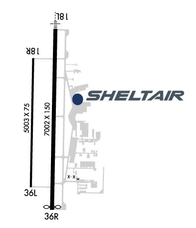
| Rwy | Rwy | |||||||
| 7002x150 | 7002' | 109.10 - 177° | 7002x150 | 6902' | ||||
| 5003x75 | 5003' | 5003x75 | 5003' | |||||
| Runway ID | Single Wheel | Double Wheel | Double Tandem Wheel | Dual Double Wheel |
| 18L/36R | 70,000 | 100,000 | N/A | N/A |
| 18R/36L | 30,000 | N/A | N/A | N/A |
| These numbers are Advisory and are not limits. The Airport Manager should have more accurate Weight Limits | ||||
 Airport Diagram might not be current. | |
| Facility Name: | DENTON ENTERPRISE |
| City Name: | DENTON |
| County: | DENTON |
| State abbrev: | TX |
| State Name: | TEXAS |
| Ownership: | PUBLICLY OWNED |
| Use: | OPEN TO THE PUBLIC |
| Owner's Name: | CITY OF DENTON |
| Address: | 601 EAST HICKORY STREET |
| DENTON, TX 76201 | |
| Owner's Phone: | 940-349-7736 |
| Manager's Name: | RYAN ADAMS |
| Address: | 5000 AIRPORT RD |
| DENTON, TX 76207-0207 | |
| Phone: | 940-349-7744; RYAN.ADAMS@CITYOFDENTON.COM |
| FAA Region: | SOUTHWEST |
| FAA Field Office: | TEX |
| Date | Sunrise | Sunset |
|---|---|---|
| 06/07/26 Sunday | 6:19 | 20:36 |
| 06/08/26 Monday | 6:19 | 20:37 |
| 06/09/26 Tuesday | 6:19 | 20:37 |
| 06/10/26 Wednesday | 6:19 | 20:37 |
| 06/11/26 Thursday | 6:19 | 20:38 |
| 06/12/26 Friday | 6:19 | 20:38 |
| 06/13/26 Saturday | 6:19 | 20:39 |
| 06/14/26 Sunday | 6:19 | 20:39 |
| 06/15/26 Monday | 6:19 | 20:39 |
| 06/16/26 Tuesday | 6:19 | 20:40 |
| 06/17/26 Wednesday | 6:19 | 20:40 |
| 06/18/26 Thursday | 6:19 | 20:40 |
| 06/19/26 Friday | 6:20 | 20:41 |
| 06/20/26 Saturday | 6:20 | 20:41 |
| Airport Attendance Schedule | 7 Days A Week 0600-2200 |
| Airport Status | OPERATIONAL (This Status can change at any time - please check NOTAMS) |
| Airport Lighting Schedule | DUSK-DAWN WHEN ATCT CLSD, MIRL RWY 18L/36R & 18R/36L PRESET TO LOW INTST; TO INCR INTST & ACTVT MALSR RWY 18L - CTAF. |
| Airport Storage Available | Tie Downs, Hanger |
| Extra Services Available | Air Freight, Avionics, Charter, Flight Instruction, Aircraft Rental, Aircraft Sales |
| Wind Indicator | YES - (lighted) |
| Control Tower | YES |
| CTAF Frequency | 119.950 |
| Unicom Frequency | |
| Rotating Beacon Color | WG |
| Segmented Circle | YES |
| Landing Fee | NO |
| Airport Inspected | STATE - performed by PRIVATE CONTRACT PERSONNEL |
| Inspection Date | 05/15/2025 |
| Type of Fuel Available | Grade 100LL, JET A (freeze point -40C) |
| Airframe Repair Service | MAJOR |
| Power Plant Repair Service | MAJOR |
| Latitude | N3312.1 |
| Longitude | W09711.9 (ESTIMATED) |
| Arpt Elevation | 642ft (SURVEYED) |
| Magnetic Variation | 04E |
| 3 miles W | of DENTON |
| Traffic Pattern Altitude | 800 |
| Sectional Chart | DALLAS-FT WORTH |
| Operations (Reported) | Yearly | Avg. Daily |
|---|---|---|
| General Aviation Transient | 0 | 0 |
| General Aviation Local | 0 | 0 |
| Air Taxi | 0 | 0 |
| Commerical | 0 | 0 |
| Commuter | 0 | 0 |
| Military | 0 | 0 |
| Aircraft based on Field | |
|---|---|
| General Aviation Singles | 0 |
| General Aviation Multi | 0 |
| Jet Aircraft | 0 |
| General Aviation Helicopters | 0 |
| Military Aircraft | 0 |
| Gliders | 0 |
| Ultralights | 0 |
| FSS on field | NO |
| FSS tie-in | FORT WORTH |
| FSS Phone | 1-800-WX-BRIEF |
| Who issues Notams | DTO |
| Notam D service at airport | YES |
| ARTCC Name | FORT WORTH |
| Airport Certification | |
| Aircraft Rescue & Firefighting Index | None |
| Airport of Entry | No |
| Custom Landing Rights | No |
| Joint Civil/Military | No |
| Military Landing rights | YES |
| NATIONAL PLAN OF INTEGRATED AIRPORT SYSTEMS (NPIAS) |
| GRANT AGREEMENTS UNDER FAAP/ADAP/AIP |
| ASSURANCES PURSUANT TO TITLE VI, CIVIL RIGHTS ACT OF 1964 |
| AGREEMENT UNDER DLAND OR DCLA HAS EXPIRED. |
| RWY 18L DESIGNATED AS A CALM WIND RWY. |
| ARPT CLSD TO ULTRALIGHTS AND GLIDERS. |
| MOWING OPNS ON ARPT MAY-SEP. |
| FOR CD WHEN ATCT IS CLSD CTC LONE STAR APCH AT 972-615-2799. |
Airport Communications & Frequencies:
| ||||||||||||||||||||||||||
| Runway: 18L | Runway: 36R | ||
| Mag heading: | 177° | Mag heading: | 357° |
| Rwy Slope: | -.18% Down | Rwy Slope: | .18% Up |
| Approach: | ILS | Approach: | |
| Pattern: | Left Traffic | Pattern: | Left Traffic |
| Markings: | PRECISION INSTRUMENT | Markings: | PRECISION INSTRUMENT |
| Marking Condition: | GOOD | Marking Condition: | GOOD |
| Arresting Dev: | Arresting Dev: | ||
| Lat & Long: | N3312.7 W09711.9 | Lat. & Long.: | N3311.5 W09711.9 |
| Elev: | 639.3 ft. MSL | Elev: | 627.0 ft. MSL |
| TCH: | 54 ft. AGL | TCH: | 50 ft. AGL |
| Visual Glide Path: | 3.00 degrees | Visual Glide Path: | 3.00 degrees |
| Displaced Threshold: | No | Displaced Threshold: | 100 feet |
| Touchdown Zone: | YES | Touchdown Zone: | YES |
| Touchdown Elev.: | 641.4 feet | Touchdown Elev.: | 638.9 feet |
| Visual Glide Slope: | 4-Light PAPI on LEFT side of Runway | Visual Glide Slope: | 4-Light PAPI on LEFT side of Runway |
| RVR Equipment: | RVR Equipment: | ||
| RVV Equipment: | NO | RVV Equipment: | NO |
| Approach Lights: | MALSR - 1,400 foot medium intensity approach lighting system with runway alignment indicator lights | Approach Lights: | |
| REIL: | NO | REIL: | NO |
| Centerline Lights: | NO | Centerline Lights: | NO |
| Touchdown lights: | NO | Touchdown lights: | NO |
| Runway Category: | Precision Instrument Runway | Runway Category: | D |
| Declared Distances: | TORA:7002' TODA:7002' ASDA:6502' LDA:6502' | Declared Distances: | TORA:7002' TODA:7002' ASDA:6602' LDA:6502' |
| Obstructions: | TREES; 15 FT LOCALIZER ANT, 500 FT DSTC, OBSTN CLNC 20:1, 40:1 TO DTHR. | Obstructions: | TREES |
| Marked: | NOT Marked/Lighted | Marked: | NOT Marked/Lighted |
| Clearance slope: | 26:1 | Clearance slope: | 34:1; OBSTN CLNC 49:1 TO DTHR OVR 20 FT TREES, 980 DSTC, 40:1 OVR LOC ANT, 600 FT DSTC. |
| Obstruction height: | 20 feet AGL | Obstruction height: | 20 feet AGL |
| Dist. from runway: | 720 feet | Dist. from runway: | 890 feet |
| Centerline offset: | 185 right of centerline | Centerline offset: | 250 feet left of centerline |
| Comments: | Comments: |
| Runway: 18R | Runway: 36L | ||
| Mag heading: | 177° | Mag heading: | 357° |
| Rwy Slope: | -.31% Down | Rwy Slope: | .31% Up |
| Approach: | Approach: | ||
| Pattern: | Left Traffic | Pattern: | Left Traffic |
| Markings: | NONPRECISION INSTRUMENT | Markings: | NONPRECISION INSTRUMENT |
| Marking Condition: | GOOD | Marking Condition: | GOOD |
| Arresting Dev: | Arresting Dev: | ||
| Lat & Long: | N3312.5 W09712.0 | Lat. & Long.: | N3311.7 W09712.1 |
| Elev: | 642.8 ft. MSL | Elev: | 627.4 ft. MSL |
| TCH: | 42 ft. AGL | TCH: | 42 ft. AGL |
| Visual Glide Path: | 3.00 degrees | Visual Glide Path: | 3.00 degrees |
| Displaced Threshold: | No | Displaced Threshold: | No |
| Touchdown Zone: | YES | Touchdown Zone: | YES |
| Touchdown Elev.: | 642.8 feet | Touchdown Elev.: | 641.4 feet |
| Visual Glide Slope: | 4-Light PAPI on LEFT side of Runway | Visual Glide Slope: | 4-Light PAPI on LEFT side of Runway |
| RVR Equipment: | RVR Equipment: | ||
| RVV Equipment: | NO | RVV Equipment: | NO |
| Approach Lights: | Approach Lights: | ||
| REIL: | NO | REIL: | NO |
| Centerline Lights: | NO | Centerline Lights: | NO |
| Touchdown lights: | NO | Touchdown lights: | NO |
| Runway Category: | Runway with a Visual Approach | Runway Category: | Runway with a Visual Approach |
| Declared Distances: | Declared Distances: |
Thanks for using FltPlan.com
all rights reserved © 1999-2026 by Flight Plan LLC