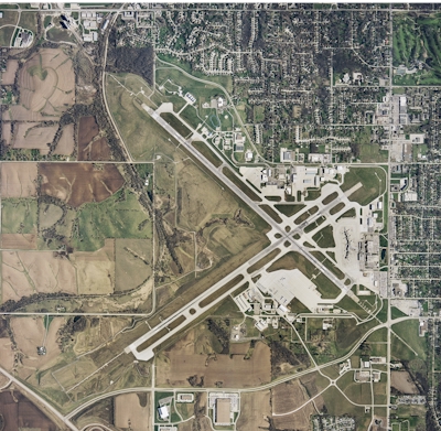
| DES MOINES INTL DES MOINES IA |
| |
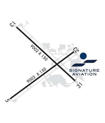
| Lat: N 4132.0 Long: W 09339.8 Elev: 958 Var: -01 Longest Runway: 9004 | ||
| Clr Del: 134.15 Dept. ATIS: 119.55 Arr. ATIS: 119.55 Ground: 121.9 Tower: 118.3 | ||
| |||||||||||||||||||||||||||||||||||||||||||||||||||||||||||||||||||||
| |||||||||||||||||||||||||||||||||||||||||||||||||||||||||||||||||||||
| |||||||||||||||||||||||||||||||||||||||||||||||||||||||||||||||||||||
| |||||||||||||||||||||||||||||||||||||||||||||||||||||||||||||||||||||
| |||||||||||||||||||||||||||||||||||||||||||||||||||||||||||||||||||||
| Rwy | Rwy | |||||||
| 9004x150 | 9004' | 111.50 - 052° | 9004x150 | 9004' | ||||
| 9001x150 | 9001' | 111.90 - 131° | 9001x150 | 9001' | 110.30 - 311° | |||
| Runway ID | Single Wheel | Double Wheel | Double Tandem Wheel | Dual Double Wheel |
| 05/23 | 100,000 | 190,000 | 360,000 | 850,000 |
| 13/31 | 100,000 | 200,000 | 360,000 | 850,000 |
| These numbers are Advisory and are not limits. The Airport Manager should have more accurate Weight Limits | ||||
 Airport Diagram might not be current. | |
| Facility Name: | DES MOINES INTL |
| City Name: | DES MOINES |
| County: | POLK |
| State abbrev: | IA |
| State Name: | IOWA |
| Ownership: | PUBLICLY OWNED |
| Use: | OPEN TO THE PUBLIC |
| Owner's Name: | DES MOINES AIRPORT AUTHORITY |
| Address: | 5800 FLEUR DRIVE, SUITE 207, ROOM 201 |
| DES MOINES, IA 50321 | |
| Owner's Phone: | 515-256-5100 |
| Manager's Name: | MR. BRIAN MULCAHY; EXEC DIR |
| Address: | 5800 FLEUR DRIVE, SUITE 207 |
| DES MOINES, IA 50321-2854 | |
| Phone: | 515-256-5100 |
| FAA Region: | CENTRAL |
| FAA Field Office: | NONE |
| Date | Sunrise | Sunset |
|---|---|---|
| 06/08/26 Monday | 5:41 | 20:47 |
| 06/09/26 Tuesday | 5:41 | 20:47 |
| 06/10/26 Wednesday | 5:40 | 20:48 |
| 06/11/26 Thursday | 5:40 | 20:48 |
| 06/12/26 Friday | 5:40 | 20:49 |
| 06/13/26 Saturday | 5:40 | 20:49 |
| 06/14/26 Sunday | 5:40 | 20:50 |
| 06/15/26 Monday | 5:40 | 20:50 |
| 06/16/26 Tuesday | 5:40 | 20:51 |
| 06/17/26 Wednesday | 5:40 | 20:51 |
| 06/18/26 Thursday | 5:40 | 20:51 |
| 06/19/26 Friday | 5:40 | 20:52 |
| 06/20/26 Saturday | 5:41 | 20:52 |
| 06/21/26 Sunday | 5:41 | 20:52 |
| Airport Attendance Schedule | CONTINUOUS |
| Airport Status | OPERATIONAL (This Status can change at any time - please check NOTAMS) |
| Airport Lighting Schedule | |
| Airport Storage Available | Tie Downs, Hanger |
| Extra Services Available | Air Freight, Air Ambulance, Avionics, Cargo Handling, Charter, Aircraft Sales, Annual Surveying |
| Wind Indicator | YES - (lighted) |
| Control Tower | YES |
| CTAF Frequency | |
| Unicom Frequency | 122.950 |
| Rotating Beacon Color | WG |
| Segmented Circle | NO |
| Landing Fee | NO |
| Airport Inspected | FEDERAL - performed by FAA AIRPORTS FIELD PERSONNEL |
| Inspection Date | 07/16/2025 |
| Type of Fuel Available | Grade 100LL, JET A (freeze point -40C) |
| Airframe Repair Service | MAJOR |
| Power Plant Repair Service | MAJOR |
| Latitude | N4132.0 |
| Longitude | W09339.8 (ESTIMATED) |
| Arpt Elevation | 957ft (SURVEYED) |
| Magnetic Variation | 01E |
| 3 miles SW | of DES MOINES |
| Traffic Pattern Altitude | |
| Sectional Chart | OMAHA |
| Operations (Reported) | Yearly | Avg. Daily |
|---|---|---|
| General Aviation Transient | 0 | 0 |
| General Aviation Local | 0 | 0 |
| Air Taxi | 0 | 0 |
| Commerical | 0 | 0 |
| Commuter | 0 | 0 |
| Military | 0 | 0 |
| Aircraft based on Field | |
|---|---|
| General Aviation Singles | 0 |
| General Aviation Multi | 0 |
| Jet Aircraft | 0 |
| General Aviation Helicopters | 0 |
| Military Aircraft | 0 |
| Gliders | 0 |
| Ultralights | 0 |
| FSS on field | NO |
| FSS tie-in | FORT DODGE |
| FSS Phone | 1-800-WX-BRIEF |
| Who issues Notams | DSM |
| Notam D service at airport | YES |
| ARTCC Name | MINNEAPOLIS |
| Airport Certification | AIRPORT RECEIVING SCHEDULED AIR CARRIER SERVICE FROM CARRIERS CERTIFICATED BY THE CIVIL AERONAUTICS BOARD |
| Aircraft Rescue & Firefighting Index | AIRPORT HAS A CERTIFICATE UNDER CFR PART 139 |
| Airport of Entry | No |
| Custom Landing Rights | YES; FLIGHT NOTIFICATION SERVICE (ADCUS) AVBL MON-FRI 0830-1700. FOR SAT; SUN; HOLS & NIGHT CUSTOMS SVC MAKE APPOINTMENTS MON-FRI 0830-1700. AT LEAST 3 HR ADVANCE NOTICE RQRD. |
| Joint Civil/Military | No |
| Military Landing rights | YES |
| NATIONAL PLAN OF INTEGRATED AIRPORT SYSTEMS (NPIAS) |
| GRANT AGREEMENTS UNDER FAAP/ADAP/AIP |
| ASSURANCES PURSUANT TO TITLE VI, CIVIL RIGHTS ACT OF 1964 |
| AGREEMENT UNDER DLAND OR DCLA HAS EXPIRED. |
| CONTR FUEL - 515-256-5330. |
| BIRDS ON & INVOF ARPT. |
| INFORMAL NOISE ABATEMENT PROCEDURES IN EFFECT. EXPECT ATC TO ASSIGN PREFERRED RY. |
| IANG SOUTH RAMP PCN 78 R/B/W/T. IANG WEST RAMP PCN 87 R/B/W/T. |
| MAX ACFT WT SOUTH GA APRN 170,000 LBS ALL OTHER FBO APRN 80,000 LBS. |
| RWY 05 APCH END HAS LTD VIS FROM THE TWR. TWR CANNOT EASILY ID IF AN ACFT IS OVER THE HOLD SHORT LINE AT TWY P7. RWY 05 ARRIVALS - USE CTN AND ENSURE YOU ARE CORRECTLY LINED UP WITH RWY 05 AND NOT TWY P. |
| CROSS BLEED ENGINE STARTS ON AIR CARRIER RAMP PROHIBITED. |
| USE CAUTION WHEN LNDG OVER RAISED LIGHTS IN THE OVERRUNS AND RWY THLDS AT DSM. |
| ARNG RAMP AVBL FOR MIL AND MIL-CONTRACTED ACFT FOR OFFL BUS ONLY WITH LTD SUPPORT. PPR; CTC DSN 261-8360/8361, C515-261-8360/8361. FBO WILL PROVIDE CONTRACT FUEL. MIL CREWS CAN CTC HAWKI ON 252.9 |
| A321 AIRCRAFT LTD TO 190,000 LBS ON RWY 5-23 AND TWY P. A321 EXCEEDING 190,000 LBS WO ARPT AUTH WAIVER REQ ATCT PRVD 13-31. |
| UPDTD: SKED A321 ACFT OVER 200,000 LBS RQR AN OVERWEIGHT ACFT PMT; CTC ARPT AUTH 515-256-5000 |
| MODERN AVIATION FBO LCTD AT NORTH GA APRON. |
| TERMINAL APRON TAXILANE ADG III AC ONLY, ADG IV AC AT GATE A4 ONLY. |
| TRML APRON TAXILANE ADG III (ACFT WINGSPAN LESS THAN 118 FT) ONLY, ADG IV (ACFT WINGSPAN LESS THAN 172 FT) ACFT AT GATE A4 ONLY. |
| TERMINAL APRON DE-ICE SPOT N2 AND ASSOCIATED TAXILANE LIMITED TO ADGII UNLESS COORDINATED WITH IDS 129.875. |
| NO TAXI BETWEEN GATES A5A AND A5B. |
| NO TAXI TO TRML GATES A2/A4 FROM TXY D1 WHEN AN AIRCRAFT IS PARKED AT REMOTE SPOT R6 - REQUEST TXY E. |
| ENTER TERMINAL DE-ICE PAD QUEUE FROM TAXILANE N, DO NOT ENTER PAD FROM TAXILANE N4. |
| TWY P E OF TWY D WINGTIP CLEARANCE LIMITED TO 121.5 FT, CAUTION ADVISED FOR ADG V AND LARGER AIRCRAFT. |
| RWY 05/2 3 PCR VALUE: 696/R/D/W/T |
| RWY 13/3 1 PCR VALUE: 696/R/D/W/T |
Airport Communications & Frequencies:
| |||||||||||||||||||||||||||||||||||||||||||||||||||||||||
| Runway: 05 | Runway: 23 | ||
| Mag heading: | 53° | Mag heading: | 233° |
| Rwy Slope: | .24% Up | Rwy Slope: | -.24% Down |
| Approach: | ILS/DME | Approach: | |
| Pattern: | Left Traffic | Pattern: | Left Traffic |
| Markings: | NONPRECISION INSTRUMENT | Markings: | NONPRECISION INSTRUMENT |
| Marking Condition: | GOOD | Marking Condition: | GOOD |
| Arresting Dev: | Arresting Dev: | ||
| Lat & Long: | N4131.4 W09340.6 | Lat. & Long.: | N4132.3 W09339.0 |
| Elev: | 915.5 ft. MSL | Elev: | 937.0 ft. MSL |
| TCH: | 55 ft. AGL | TCH: | 60 ft. AGL |
| Visual Glide Path: | 3.00 degrees | Visual Glide Path: | 3.00 degrees |
| Displaced Threshold: | No | Displaced Threshold: | No |
| Touchdown Zone: | YES | Touchdown Zone: | YES |
| Touchdown Elev.: | 931.2 feet | Touchdown Elev.: | 939.6 feet |
| Visual Glide Slope: | 4-Light PAPI on LEFT side of Runway | Visual Glide Slope: | 4-Light PAPI on LEFT side of Runway; PAPI UNUSBL BYD 9 DEGS RIGHT OF CNTRLN. |
| RVR Equipment: | TOUCHDOWN | RVR Equipment: | ROLLOUT |
| RVV Equipment: | NO | RVV Equipment: | NO |
| Approach Lights: | MALSR - 1,400 foot medium intensity approach lighting system with runway alignment indicator lights | Approach Lights: | |
| REIL: | YES | REIL: | YES |
| Centerline Lights: | NO | Centerline Lights: | NO |
| Touchdown lights: | NO | Touchdown lights: | NO |
| Runway Category: | Precision Instrument Runway | Runway Category: | Runway with a Non-precision Approach having visibility minimums greater than 3/4 mile |
| Declared Distances: | Declared Distances: | ||
| Obstructions: | Obstructions: | POLE | |
| Marked: | Marked: | LIGHTED | |
| Clearance slope: | 50:1 | Clearance slope: | 34:1 |
| Obstruction height: | Obstruction height: | 67 feet AGL | |
| Dist. from runway: | Dist. from runway: | 2322 feet | |
| Centerline offset: | Centerline offset: | 375 feet left of centerline | |
| Comments: | Comments: |
| Runway: 13 | Runway: 31 | ||
| Mag heading: | 131° | Mag heading: | 311° |
| Rwy Slope: | .50% Up | Rwy Slope: | -.50% Down |
| Approach: | ILS/DME | Approach: | ILS/DME |
| Pattern: | Left Traffic | Pattern: | Right Traffic |
| Markings: | PRECISION INSTRUMENT | Markings: | PRECISION INSTRUMENT |
| Marking Condition: | GOOD | Marking Condition: | GOOD |
| Arresting Dev: | Arresting Dev: | ||
| Lat & Long: | N4132.7 W09340.5 | Lat. & Long.: | N4131.7 W09339.0 |
| Elev: | 912.6 ft. MSL | Elev: | 957.8 ft. MSL |
| TCH: | 54 ft. AGL | TCH: | 52 ft. AGL |
| Visual Glide Path: | 3.00 degrees | Visual Glide Path: | 3.00 degrees |
| Displaced Threshold: | No | Displaced Threshold: | No |
| Touchdown Zone: | YES | Touchdown Zone: | YES |
| Touchdown Elev.: | 923.5 feet | Touchdown Elev.: | 957.8 feet |
| Visual Glide Slope: | 4-Light PAPI on RIGHT side of Runway | Visual Glide Slope: | 4-Light PAPI on LEFT side of Runway |
| RVR Equipment: | TOUCHDOWN-MIDFIELD-ROLLOUT | RVR Equipment: | TOUCHDOWN-MIDFIELD-ROLLOUT |
| RVV Equipment: | NO | RVV Equipment: | NO |
| Approach Lights: | MALSR - 1,400 foot medium intensity approach lighting system with runway alignment indicator lights | Approach Lights: | ALSF2 - standard 2,400 foot high intensity approach lighting system with sequenced flashers, Category II or III |
| REIL: | NO | REIL: | NO |
| Centerline Lights: | YES | Centerline Lights: | YES |
| Touchdown lights: | NO | Touchdown lights: | YES |
| Runway Category: | Precision Instrument Runway | Runway Category: | Precision Instrument Runway |
| Declared Distances: | TORA:9001' TODA:9001' ASDA:9001' LDA:9001' | Declared Distances: | TORA:9001' TODA:9001' ASDA:9001' LDA:9001' |
Thanks for using FltPlan.com
all rights reserved © 1999-2026 by Flight Plan LLC