
| BEAUREGARD RGNL DE RIDDER LA |
| |
| Lat: N 3049.9 Long: W 09320.4 Elev: 202 Var: -04 Longest Runway: 5494 | ||
| AWOS: 118.22 CTAF: 122.8 | ||
| ||||||||||||||||||||||||||||||||||||||||||||
| ||||||||||||||||||||||||||||||||||||||||||||
| ||||||||||||||||||||||||||||||||||||||||||||
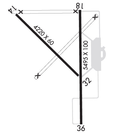
| Rwy | Rwy | |||||||
| 4218x60 | 3764' | 4218x60 | 4218' | |||||
| 5494x100 | 5494' | 5494x100 | 5494' | 111.10 - 355° | ||||
| Runway ID | Single Wheel | Double Wheel | Double Tandem Wheel | Dual Double Wheel |
| 14/32 | N/A | N/A | N/A | N/A |
| 18/36 | 60,000 | N/A | N/A | N/A |
| These numbers are Advisory and are not limits. The Airport Manager should have more accurate Weight Limits | ||||
 Airport Diagram might not be current. | |
| Facility Name: | BEAUREGARD RGNL |
| City Name: | DE RIDDER |
| County: | BEAUREGARD |
| State abbrev: | LA |
| State Name: | LOUISIANA |
| Ownership: | PUBLICLY OWNED |
| Use: | OPEN TO THE PUBLIC |
| Owner's Name: | BEAUREGARD PARISH |
| Address: | 1220 1ST AVE |
| DERIDDER, LA 70634 | |
| Owner's Phone: | 337-463-8250 |
| Manager's Name: | SAM LACK |
| Address: | 1220 1ST AVE |
| DERIDDER, LA 70634 | |
| Phone: | 337-463-8250 |
| FAA Region: | SOUTHWEST |
| FAA Field Office: | LNM |
| Date | Sunrise | Sunset |
|---|---|---|
| 06/08/26 Monday | 6:10 | 20:15 |
| 06/09/26 Tuesday | 6:10 | 20:16 |
| 06/10/26 Wednesday | 6:10 | 20:16 |
| 06/11/26 Thursday | 6:10 | 20:16 |
| 06/12/26 Friday | 6:10 | 20:17 |
| 06/13/26 Saturday | 6:10 | 20:17 |
| 06/14/26 Sunday | 6:10 | 20:18 |
| 06/15/26 Monday | 6:10 | 20:18 |
| 06/16/26 Tuesday | 6:10 | 20:18 |
| 06/17/26 Wednesday | 6:10 | 20:19 |
| 06/18/26 Thursday | 6:10 | 20:19 |
| 06/19/26 Friday | 6:10 | 20:19 |
| 06/20/26 Saturday | 6:10 | 20:19 |
| 06/21/26 Sunday | 6:11 | 20:20 |
| Airport Attendance Schedule | MON-FRI 0800-1700; FOR ATTENDANT OTHER TIMES CALL 337-401-2967. |
| Airport Status | OPERATIONAL (This Status can change at any time - please check NOTAMS) |
| Airport Lighting Schedule | REIL RWY 18 AND MIRL RWY 18/36 PRESET LOW INTST DUSK-DAWN; TO INCR INTST ACTVT - CTAF. |
| Airport Storage Available | Tie Downs, Hanger |
| Extra Services Available | Crop Dusting, Flight Instruction, Parachute Jumping, Aircraft Rental |
| Wind Indicator | YES - (lighted) |
| Control Tower | NO |
| CTAF Frequency | 122.800 |
| Unicom Frequency | 122.800 |
| Rotating Beacon Color | WG |
| Segmented Circle | NO |
| Landing Fee | NO |
| Airport Inspected | STATE - performed by STATE AERONAUTICAL PERSONNEL |
| Inspection Date | 10/10/2023 |
| Type of Fuel Available | Grade 100LL, JET A (freeze point -40C); -10100LL AVBL 24 HRS SELF SERVICE WITH CREDIT CARD. FOR JET A AFT HRS & HOLS CALL 337-401-2967. |
| Airframe Repair Service | MINOR |
| Power Plant Repair Service | MINOR |
| Latitude | N3049.9 |
| Longitude | W09320.4 (ESTIMATED) |
| Arpt Elevation | 201ft (SURVEYED) |
| Magnetic Variation | 04E |
| 3 miles SW | of DE RIDDER |
| Traffic Pattern Altitude | 1000 |
| Sectional Chart | HOUSTON |
| Operations (Reported) | Yearly | Avg. Daily |
|---|---|---|
| General Aviation Transient | 0 | 0 |
| General Aviation Local | 0 | 0 |
| Air Taxi | 0 | 0 |
| Commerical | 0 | 0 |
| Commuter | 0 | 0 |
| Military | 0 | 0 |
| Aircraft based on Field | |
|---|---|
| General Aviation Singles | 0 |
| General Aviation Multi | 0 |
| Jet Aircraft | 0 |
| General Aviation Helicopters | 0 |
| Military Aircraft | 0 |
| Gliders | 0 |
| Ultralights | 0 |
| FSS on field | NO |
| FSS tie-in | DE RIDDER |
| FSS Phone | 1-800-WX-BRIEF |
| Who issues Notams | DRI |
| Notam D service at airport | YES |
| ARTCC Name | HOUSTON |
| Airport Certification | |
| Aircraft Rescue & Firefighting Index | None |
| Airport of Entry | No |
| Custom Landing Rights | No |
| Joint Civil/Military | No |
| Military Landing rights | YES |
| NATIONAL PLAN OF INTEGRATED AIRPORT SYSTEMS (NPIAS) |
| GRANT AGREEMENTS UNDER FAAP/ADAP/AIP |
| SURPLUS PROPERTY AGREEMENT UNDER PUBLIC LAW 289 |
| ASSURANCES PURSUANT TO TITLE VI, CIVIL RIGHTS ACT OF 1964 |
| FOR CD IF UNA TO CTC ON FSS FREQ, CTC MAKS APCH AT 726-780-0456. |
| CTC APRT MGR FOR DSGND RAMP SPACE FOR PUB USE. |
| COMMUNICATIONS: MAKS APP VOIP 726-780-0456 |
Airport Communications & Frequencies:
| ||||||||||||||
| Runway: 14 | Runway: 32 | ||
| Mag heading: | 130° | Mag heading: | 310° |
| Rwy Slope: | .03% Up | Rwy Slope: | -.03% Down |
| Approach: | Approach: | ||
| Pattern: | Left Traffic | Pattern: | Left Traffic |
| Markings: | BASIC | Markings: | BASIC |
| Marking Condition: | FAIR | Marking Condition: | FAIR |
| Arresting Dev: | Arresting Dev: | ||
| Lat & Long: | N3050.2 W09320.9 | Lat. & Long.: | N3049.8 W09320.3 |
| Elev: | 191.5 ft. MSL | Elev: | 192.8 ft. MSL |
| TCH: | TCH: | ||
| Visual Glide Path: | Visual Glide Path: | ||
| Displaced Threshold: | 454 feet | Displaced Threshold: | No |
| Touchdown Zone: | YES | Touchdown Zone: | YES |
| Touchdown Elev.: | 194.1 feet | Touchdown Elev.: | 194.0 feet |
| Visual Glide Slope: | Visual Glide Slope: | ||
| RVR Equipment: | RVR Equipment: | ||
| RVV Equipment: | NO | RVV Equipment: | NO |
| Approach Lights: | Approach Lights: | ||
| REIL: | NO | REIL: | NO |
| Centerline Lights: | NO | Centerline Lights: | NO |
| Touchdown lights: | NO | Touchdown lights: | NO |
| Runway Category: | Runway with a Visual Approach | Runway Category: | Runway with a Visual Approach |
| Declared Distances: | Declared Distances: | ||
| Obstructions: | TREES | Obstructions: | TREES |
| Marked: | NOT Marked/Lighted | Marked: | NOT Marked/Lighted |
| Clearance slope: | 15:1; APCH SLP 20:1 TO DSPLCD THR. | Clearance slope: | 22:1 |
| Obstruction height: | 81 feet AGL | Obstruction height: | 65 feet AGL |
| Dist. from runway: | 1426 feet | Dist. from runway: | 1635 feet |
| Centerline offset: | 163 right of centerline | Centerline offset: | 114 feet left of centerline |
| Comments: | Comments: |
| Runway: 18 | Runway: 36 | ||
| Mag heading: | 175° | Mag heading: | 355° |
| Rwy Slope: | -.08% Down | Rwy Slope: | .08% Up |
| Approach: | Approach: | LOCALIZER | |
| Pattern: | Left Traffic | Pattern: | Left Traffic |
| Markings: | NONPRECISION INSTRUMENT | Markings: | NONPRECISION INSTRUMENT |
| Marking Condition: | POOR; RUNWAY 18 MARKINGS FADED | Marking Condition: | POOR; RUNWAY 36 MARKINGS FADED |
| Arresting Dev: | Arresting Dev: | ||
| Lat & Long: | N3050.3 W09320.3 | Lat. & Long.: | N3049.4 W09320.3 |
| Elev: | 201.1 ft. MSL | Elev: | 196.7 ft. MSL |
| TCH: | 50 ft. AGL | TCH: | 50 ft. AGL |
| Visual Glide Path: | 3.00 degrees | Visual Glide Path: | 3.00 degrees |
| Displaced Threshold: | No | Displaced Threshold: | No |
| Touchdown Zone: | YES | Touchdown Zone: | YES |
| Touchdown Elev.: | 201.8 feet | Touchdown Elev.: | 196.9 feet |
| Visual Glide Slope: | 4-Light PAPI on RIGHT side of Runway | Visual Glide Slope: | 4-Light PAPI on LEFT side of Runway |
| RVR Equipment: | RVR Equipment: | ||
| RVV Equipment: | NO | RVV Equipment: | NO |
| Approach Lights: | Approach Lights: | ODALS - omnidirectional approach lighting system | |
| REIL: | YES | REIL: | NO |
| Centerline Lights: | NO | Centerline Lights: | NO |
| Touchdown lights: | NO | Touchdown lights: | NO |
| Runway Category: | Runway with a Non-precision Approach having visibility minimums greater than 3/4 mile | Runway Category: | Runway with a Non-precision Approach having visibility minimums greater than 3/4 mile |
| Declared Distances: | Declared Distances: | ||
| Obstructions: | TREES | Obstructions: | TREES |
| Marked: | NOT Marked/Lighted | Marked: | NOT Marked/Lighted |
| Clearance slope: | 23:1 | Clearance slope: | 26:1 |
| Obstruction height: | 95 feet AGL | Obstruction height: | 74 feet AGL |
| Dist. from runway: | 2437 feet | Dist. from runway: | 2169 feet |
| Centerline offset: | Centerline offset: | 226 feet right of centerline | |
| Comments: | Comments: |
Thanks for using FltPlan.com
all rights reserved © 1999-2026 by Flight Plan LLC
