
| DUPLIN CO KENANSVILLE NC |
| |
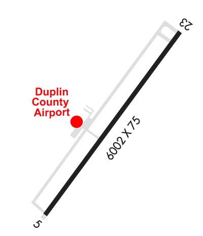
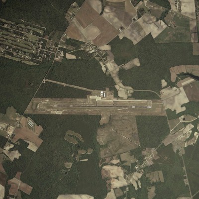
| Lat: N 3500.0 Long: W 07758.9 Elev: 137 Var: +09 Longest Runway: 6003 | ||
| AWOS: 120.67 CTAF: 123.0 | ||
| |||||||||||||||||||||||||||||||||||||||||||||||||||||||||||||||||||||
| |||||||||||||||||||||||||||||||||||||||||||||||||||||||||||||||||||||
| |||||||||||||||||||||||||||||||||||||||||||||||||||||||||||||||||||||
| Rwy | Rwy | |||||||
| 6003x100 | 6003' | 6003x100 | 6003' | 110.10 - 223° | ||||
| Runway ID | Single Wheel | Double Wheel | Double Tandem Wheel | Dual Double Wheel |
| 05/23 | 50,000 | 75,000 | N/A | N/A |
| These numbers are Advisory and are not limits. The Airport Manager should have more accurate Weight Limits | ||||
 Airport Diagram might not be current. | |
| Facility Name: | DUPLIN COUNTY |
| City Name: | KENANSVILLE |
| County: | DUPLIN |
| State abbrev: | NC |
| State Name: | NORTH CAROLINA |
| Ownership: | PUBLICLY OWNED |
| Use: | OPEN TO THE PUBLIC |
| Owner's Name: | DUPLIN COUNTY |
| Address: | 260 AIRPORT ROAD |
| KENANSVILLE, NC 28349 | |
| Owner's Phone: | 910-296-2188 |
| Manager's Name: | GEORGE FUTRELLE |
| Address: | 260 AIRPORT ROAD |
| KENANSVILLE, NC 28349 | |
| Phone: | 910-296-2188 |
| FAA Region: | SOUTHERN |
| FAA Field Office: | MEM |
| Date | Sunrise | Sunset |
|---|---|---|
| 09/24/21 Friday | 7:01 | 19:06 |
| 09/25/21 Saturday | 7:02 | 19:05 |
| 09/26/21 Sunday | 7:03 | 19:03 |
| 09/27/21 Monday | 7:03 | 19:02 |
| 09/28/21 Tuesday | 7:04 | 19:00 |
| 09/29/21 Wednesday | 7:05 | 18:59 |
| 09/30/21 Thursday | 7:06 | 18:58 |
| 10/01/21 Friday | 7:06 | 18:56 |
| 10/02/21 Saturday | 7:07 | 18:55 |
| 10/03/21 Sunday | 7:08 | 18:53 |
| 10/04/21 Monday | 7:09 | 18:52 |
| 10/05/21 Tuesday | 7:10 | 18:51 |
| 10/06/21 Wednesday | 7:10 | 18:49 |
| 10/07/21 Thursday | 7:11 | 18:48 |
| Airport Attendance Schedule | APR-OCT MON-FRI 0700-1900, APR-OCT SUN 1300-1900, NOV-MAR SAT 0800-1800, NOV-MAR MON-FRI 0700-1800, NOV-MAR SUN 1300-1800, APR-OCT SAT 0800-1900; UNATTENDED THANKSGIVING AND CHRISTMAS. |
| Airport Status | OPERATIONAL (This Status can change at any time - please check NOTAMS) |
| Airport Lighting Schedule | ACTVT REIL RWY 05 & 23 - CTAF. MIRL RWY 05/23 ON UNTIL MIDNIGHT. AFTER MIDNIGHT, ACTVT MIRL RWY 05/23 - CTAF. |
| Airport Storage Available | Tie Downs |
| Extra Services Available | NONE |
| Wind Indicator | YES - (lighted) |
| Control Tower | NO |
| CTAF Frequency | 123.000 |
| Unicom Frequency | 123.000 |
| Rotating Beacon Color | CLEAR-GREEN (Light Land Airport) |
| Segmented Circle | YES |
| Landing Fee | NO |
| Airport Inspected | STATE - performed by STATE AERONAUTICAL PERSONNEL |
| Inspection Date | 07/03/2020 |
| Type of Fuel Available | Grade 100LL, JET A-1 (icing inhibitor, freeze point -50C); -10FUEL 24 HR CREDIT CARD SVC AVBL. |
| Airframe Repair Service | MAJOR |
| Power Plant Repair Service | MAJOR |
| Latitude | N3500.0 |
| Longitude | W07758.9 (ESTIMATED) |
| Arpt Elevation | 136ft (SURVEYED) |
| Magnetic Variation | 09W |
| 2 miles NW | of KENANSVILLE |
| Traffic Pattern Altitude | |
| Sectional Chart | CHARLOTTE |
| Operations (Reported) | Yearly | Avg. Daily |
|---|---|---|
| General Aviation Transient | 9000 | 25 |
| General Aviation Local | 5500 | 15 |
| Air Taxi | 0 | 0 |
| Commerical | 0 | 0 |
| Commuter | 0 | 0 |
| Military | 3000 | 8 |
| Aircraft based on Field | |
|---|---|
| General Aviation Singles | 19 |
| General Aviation Multi | 10 |
| Jet Aircraft | 2 |
| General Aviation Helicopters | 1 |
| Military Aircraft | 0 |
| Gliders | 1 |
| Ultralights | 0 |
| FSS on field | NO |
| FSS tie-in | RALEIGH |
| FSS Phone | 1-800-WX-BRIEF |
| Who issues Notams | DPL |
| Notam D service at airport | YES |
| ARTCC Name | WASHINGTON |
| Airport Certification | |
| Aircraft Rescue & Firefighting Index | None |
| Airport of Entry | No |
| Custom Landing Rights | No |
| Joint Civil/Military | No |
| Military Landing rights | YES |
| NATIONAL PLAN OF INTEGRATED AIRPORT SYSTEMS (NPIAS) |
| GRANT AGREEMENTS UNDER FAAP/ADAP/AIP |
| ASSURANCES PURSUANT TO TITLE VI, CIVIL RIGHTS ACT OF 1964 |
| DEER/DOGS/BIRDS ON & INVOF ARPT. |
| MIL ACFT LAND FORWARD OF NUMBERS AND LIMIT DELAY ON RY TO AVOID DAMAGE TO RY SURFACES. |
| NOISE ABATEMENT PROCEDURES IN EFFECT, CALL AMGR 910-296-2188. |
| DUPLIN CO ARPT CLSD TO TOUCH & GO/PRACTICE APPROACHES 2100-0600 LCL DLY. (ALL OTHER TIMES T&G/PRACTICE APPROACHES LIMITED TO 30 MINUTES EACH). |
| ARPT CLSD TO MIL ACFT EXCEPT 1 HR PPR. |
| CD CTC SEYMOUR JOHNSON APCH AT 919-722-4186. |
Airport Communications & Frequencies:
| |||||||||||||||||
| Runway: 05 | Runway: 23 | ||
| Mag heading: | 45° | Mag heading: | 225° |
| Rwy Slope: | .03% Up | Rwy Slope: | -.03% Down |
| Approach: | Approach: | LOCALIZER | |
| Pattern: | Left Traffic | Pattern: | Left Traffic |
| Markings: | NONPRECISION INSTRUMENT | Markings: | NONPRECISION INSTRUMENT |
| Marking Condition: | GOOD | Marking Condition: | GOOD |
| Arresting Dev: | Arresting Dev: | ||
| Lat & Long: | N3459.6 W07759.3 | Lat. & Long.: | N3500.4 W07758.5 |
| Elev: | 134.6 ft. MSL | Elev: | 136.3 ft. MSL |
| TCH: | 28 ft. AGL | TCH: | 46 ft. AGL |
| Visual Glide Path: | 3.00 degrees | Visual Glide Path: | 3.00 degrees |
| Displaced Threshold: | No | Displaced Threshold: | No |
| Touchdown Zone: | YES | Touchdown Zone: | YES |
| Touchdown Elev.: | 135.0 feet | Touchdown Elev.: | 136.6 feet |
| Visual Glide Slope: | 4-Light PAPI on LEFT side of Runway | Visual Glide Slope: | 4-Light PAPI on LEFT side of Runway |
| RVR Equipment: | RVR Equipment: | ||
| RVV Equipment: | NO | RVV Equipment: | NO |
| Approach Lights: | Approach Lights: | ||
| REIL: | YES | REIL: | YES |
| Centerline Lights: | NO | Centerline Lights: | NO |
| Touchdown lights: | NO | Touchdown lights: | NO |
| Runway Category: | Runway with a Non-precision Approach having visibility minimums greater than 3/4 mile | Runway Category: | Runway with a Non-precision Approach having visibility minimums greater than 3/4 mile |
| Declared Distances: | Declared Distances: | ||
| Obstructions: | TREES | Obstructions: | TREES |
| Marked: | NOT Marked/Lighted | Marked: | NOT Marked/Lighted |
| Clearance slope: | 48:1 | Clearance slope: | 29:1 |
| Obstruction height: | 37 feet AGL | Obstruction height: | 50 feet AGL |
| Dist. from runway: | 1978 feet | Dist. from runway: | 1687 feet |
| Centerline offset: | 292 left of centerline | Centerline offset: | 201 feet left of centerline |
| Comments: | Comments: |
Thanks for using FltPlan.com
all rights reserved © 1999-2021 by Flight Plan LLC


