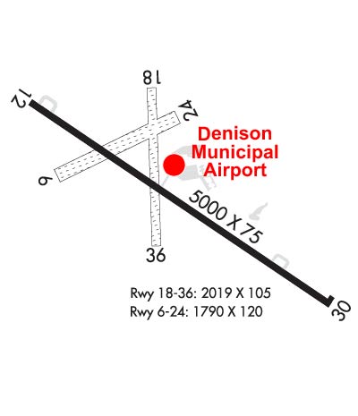
| DENISON MUNI DENISON IA |
| |
| Lat: N 4159.2 Long: W 09522.8 Elev: 1274 Var: -04 Longest Runway: 5000 | ||
| AWOS: 119.95 CTAF: 122.8 | ||
| ||||||||||||||||||||||||||||||||||||||||||||||||||||||||||||||||||||
| ||||||||||||||||||||||||||||||||||||||||||||||||||||||||||||||||||||
| ||||||||||||||||||||||||||||||||||||||||||||||||||||||||||||||||||||
| Rwy | Rwy | |||||||
| 5000x75 | 5000' | 5000x75 | 5000' | |||||
| 2019x105 | 2019' | 2019x105 | 2019' | |||||
| Runway ID | Single Wheel | Double Wheel | Double Tandem Wheel | Dual Double Wheel |
| 12/30 | 28,000 | 48,000 | N/A | N/A |
| 18/36 | N/A | N/A | N/A | N/A |
| These numbers are Advisory and are not limits. The Airport Manager should have more accurate Weight Limits | ||||
 Airport Diagram might not be current. | |
| Facility Name: | DENISON MUNI |
| City Name: | DENISON |
| County: | CRAWFORD |
| State abbrev: | IA |
| State Name: | IOWA |
| Ownership: | PUBLICLY OWNED |
| Use: | OPEN TO THE PUBLIC |
| Owner's Name: | CITY OF DENISON |
| Address: | 111 NORTH MAIN |
| DENISON, IA 51442 | |
| Owner's Phone: | 712-263-3143 |
| Manager's Name: | RYAN LEED |
| Address: | 2582 AIRPORT ST |
| DENISON, IA 51442 | |
| Phone: | 712-263-6424 |
| FAA Region: | CENTRAL |
| FAA Field Office: | NONE |
| Date | Sunrise | Sunset |
|---|---|---|
| 09/24/21 Friday | 7:11 | 19:16 |
| 09/25/21 Saturday | 7:12 | 19:14 |
| 09/26/21 Sunday | 7:13 | 19:12 |
| 09/27/21 Monday | 7:14 | 19:10 |
| 09/28/21 Tuesday | 7:15 | 19:09 |
| 09/29/21 Wednesday | 7:16 | 19:07 |
| 09/30/21 Thursday | 7:17 | 19:05 |
| 10/01/21 Friday | 7:18 | 19:03 |
| 10/02/21 Saturday | 7:19 | 19:02 |
| 10/03/21 Sunday | 7:20 | 19:00 |
| 10/04/21 Monday | 7:21 | 18:58 |
| 10/05/21 Tuesday | 7:23 | 18:57 |
| 10/06/21 Wednesday | 7:24 | 18:55 |
| 10/07/21 Thursday | 7:25 | 18:53 |
| Airport Attendance Schedule | MON - FRI 0800-1700; AFTER 1700 CALL 712-210-1900 |
| Airport Status | OPERATIONAL (This Status can change at any time - please check NOTAMS) |
| Airport Lighting Schedule | MIRL RWY 12/30 PRESET ON LOW INTST; TO INCR INTST AND ACTVT PAPI RWYS 12 AND 30 AND REIL RWYS 12 AND 30 - CTAF. |
| Airport Storage Available | Tie Downs, Hanger |
| Extra Services Available | NONE |
| Wind Indicator | YES - (lighted) |
| Control Tower | NO |
| CTAF Frequency | 122.800 |
| Unicom Frequency | 122.800 |
| Rotating Beacon Color | CLEAR-GREEN (Light Land Airport) |
| Segmented Circle | NO |
| Landing Fee | NO |
| Airport Inspected | STATE - performed by STATE AERONAUTICAL PERSONNEL |
| Inspection Date | 10/18/2018 |
| Type of Fuel Available | Grade 100LL, JET A (freeze point -40C); -10FOR FUEL CALL AMGR 712-263-6424 OR (CELL) 712-210-1900. |
| Airframe Repair Service | NONE |
| Power Plant Repair Service | NONE |
| Latitude | N4159.2 |
| Longitude | W09522.8 (ESTIMATED) |
| Arpt Elevation | 1274ft (SURVEYED) |
| Magnetic Variation | 04E |
| 2 miles SW | of DENISON |
| Traffic Pattern Altitude | |
| Sectional Chart | OMAHA |
| Operations (Reported) | Yearly | Avg. Daily |
|---|---|---|
| General Aviation Transient | 4400 | 12 |
| General Aviation Local | 3551 | 10 |
| Air Taxi | 191 | 1 |
| Commerical | 0 | 0 |
| Commuter | 0 | 0 |
| Military | 25 | 0 |
| Aircraft based on Field | |
|---|---|
| General Aviation Singles | 8 |
| General Aviation Multi | 1 |
| Jet Aircraft | 0 |
| General Aviation Helicopters | 0 |
| Military Aircraft | 0 |
| Gliders | 0 |
| Ultralights | 0 |
| FSS on field | NO |
| FSS tie-in | FORT DODGE |
| FSS Phone | 1-800-WX-BRIEF |
| Who issues Notams | DNS |
| Notam D service at airport | YES |
| ARTCC Name | MINNEAPOLIS |
| Airport Certification | |
| Aircraft Rescue & Firefighting Index | None |
| Airport of Entry | No |
| Custom Landing Rights | No |
| Joint Civil/Military | No |
| Military Landing rights | YES |
| NATIONAL PLAN OF INTEGRATED AIRPORT SYSTEMS (NPIAS) |
| GRANT AGREEMENTS UNDER FAAP/ADAP/AIP |
| ASSURANCES PURSUANT TO TITLE VI, CIVIL RIGHTS ACT OF 1964 |
| RY 30 IS CALM WIND RY. |
| CAUTION FOR WILDLIFE IN VICINITY |
| FOR CD IF UNA TO CTC ON FSS FREQ, CTC MINNEAPOLIS ARTCC AT 651-463-5588. |
| RWY 18/3 6 CLSD NOV-APR. |
Airport Communications & Frequencies:
| |||||||||
| Runway: 12 | Runway: 30 | ||
| Mag heading: | 120° | Mag heading: | 300° |
| Rwy Slope: | -.32% Down | Rwy Slope: | .32% Up |
| Approach: | Approach: | ||
| Pattern: | Left Traffic | Pattern: | Left Traffic |
| Markings: | NONPRECISION INSTRUMENT | Markings: | NONPRECISION INSTRUMENT |
| Marking Condition: | GOOD | Marking Condition: | GOOD |
| Arresting Dev: | Arresting Dev: | ||
| Lat & Long: | N4159.4 W09523.2 | Lat. & Long.: | N4158.9 W09522.3 |
| Elev: | 1273.9 ft. MSL | Elev: | 1258.0 ft. MSL |
| TCH: | 27 ft. AGL | TCH: | 35 ft. AGL |
| Visual Glide Path: | 3.00 degrees | Visual Glide Path: | 3.00 degrees |
| Displaced Threshold: | No | Displaced Threshold: | No |
| Touchdown Zone: | YES | Touchdown Zone: | YES |
| Touchdown Elev.: | 1274.0 feet | Touchdown Elev.: | 1266.0 feet |
| Visual Glide Slope: | 2-Light PAPI on LEFT side of Runway | Visual Glide Slope: | 2-Light PAPI on LEFT side of Runway |
| RVR Equipment: | RVR Equipment: | ||
| RVV Equipment: | NO | RVV Equipment: | NO |
| Approach Lights: | Approach Lights: | ||
| REIL: | YES | REIL: | YES |
| Centerline Lights: | NO | Centerline Lights: | NO |
| Touchdown lights: | NO | Touchdown lights: | NO |
| Runway Category: | Runway with a Non-precision Approach having visibility minimums greater than 3/4 mile | Runway Category: | Runway with a Non-precision Approach having visibility minimums greater than 3/4 mile |
| Declared Distances: | Declared Distances: | ||
| Obstructions: | Obstructions: | GND | |
| Marked: | Marked: | NOT Marked/Lighted | |
| Clearance slope: | 50:1 | Clearance slope: | 9:1 |
| Obstruction height: | Obstruction height: | 21 feet AGL | |
| Dist. from runway: | Dist. from runway: | 399 feet | |
| Centerline offset: | Centerline offset: | 244 feet right of centerline | |
| Comments: | Comments: | 21' TREE, 105' FM RWY END, 164' RIGHT ON APCH. |
| Runway: 18 | Runway: 36 | ||
| Mag heading: | 174° | Mag heading: | 354° |
| Rwy Slope: | -.86% Down | Rwy Slope: | .86% Up |
| Approach: | Approach: | ||
| Pattern: | Left Traffic | Pattern: | Left Traffic |
| Markings: | Markings: | ||
| Marking Condition: | 18/36 THRS & SIDES MARKED WITH YELLOW CONES. | Marking Condition: | |
| Arresting Dev: | Arresting Dev: | ||
| Lat & Long: | N4159.4 W09522.9 | Lat. & Long.: | N4159.1 W09522.8 |
| Elev: | 1273.7 ft. MSL | Elev: | 1256.4 ft. MSL |
| TCH: | TCH: | ||
| Visual Glide Path: | Visual Glide Path: | ||
| Displaced Threshold: | No | Displaced Threshold: | No |
| Touchdown Zone: | YES | Touchdown Zone: | YES |
| Touchdown Elev.: | 1273.7 feet | Touchdown Elev.: | 1273.7 feet |
| Visual Glide Slope: | Visual Glide Slope: | ||
| RVR Equipment: | RVR Equipment: | ||
| RVV Equipment: | NO | RVV Equipment: | NO |
| Approach Lights: | Approach Lights: | ||
| REIL: | NO | REIL: | NO |
| Centerline Lights: | NO | Centerline Lights: | NO |
| Touchdown lights: | NO | Touchdown lights: | NO |
| Runway Category: | Runway with a Visual Approach | Runway Category: | Runway with a Visual Approach |
| Declared Distances: | Declared Distances: |
Thanks for using FltPlan.com
all rights reserved © 1999-2021 by Flight Plan LLC